The dry stretch of weather in Iowa looks set to continue for the next couple of weeks, offering both challenges and opportunities depending on your perspective. While those hoping for some rain may be disappointed, farmers across the state are benefiting from the favorable conditions for harvesting corn and soybeans. The lack of rain has allowed fields to dry out, making it easier for farmers to bring in their crops without interruption.
High-pressure systems and blocking ridges have dominated, creating a stagnant weather pattern that is keeping moisture at bay and leaving much of the Midwest parched. As we enter early October, it appears this trend is here to stay.

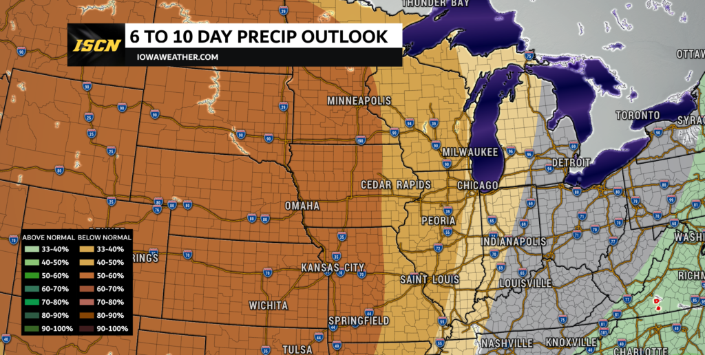
According to the latest 6 to 10-day precipitation outlook from the Climate Prediction Center, there is a 50% to 60% probability for below-normal precipitation across a large portion of Iowa during the period from October 5th through the 9th. This suggests that the ongoing dry conditions will continue for at least the next week.

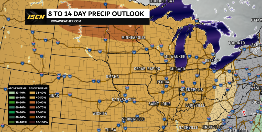
In addition, the 8 to 14-day precipitation outlook, covering October 7th through 13th, indicates a 40% to 50% chance of below-normal precipitation. Essentially, for the next two weeks, we can expect little to no significant rainfall across the region, which will maintain the dry conditions we’ve been experiencing lately.
This pattern of wash, rinse, and repeat is largely being driven by a blocking ridge straddling the central United States, limiting the movement of any substantial weather systems through the area. The weather map this morning shows high pressure extending from southern Canada all the way to the Gulf Coast, keeping our region sunny and dry. Aloft, there is a notable lack of moisture over the entire region, with dew points below zero at the H850 level stretching from Canada down through the Northern Plains, Iowa, and beyond.
The upcoming week will continue with mild temperatures and no significant rainfall expected. A weak cold front will sweep through Iowa late Monday, but it will bring nothing more than a few clouds. Temperatures on Monday will reach the mid to upper 80s, and while a brief cooldown is expected behind the front on Tuesday, highs will still be comfortable in the mid 60s to around 70. The pattern will quickly warm back up, with highs reaching the upper 70s to low 80s by Wednesday.
As high pressure moves in again later this week, temperatures will remain mild, with highs generally in the 70s to low 80s. Several weak systems will pass through, bringing with them little more than a few clouds and occasional breezy conditions. The overall pattern remains dry, with no meaningful rainfall expected through at least mid-October.

For farmers, this ongoing dry weather has been a blessing for the harvest season. The dry conditions have allowed them to access their fields without worrying about mud or soggy ground, and many have been able to make good progress in harvesting corn and soybeans. With relative humidity levels dropping as low as 25% at times, especially in the northwest, it’s essential to stay mindful of elevated fire weather conditions, especially with the ongoing farm operations. Saturday, in particular, may be a day of concern due to potential gusty winds and very low humidity levels.
For now, it seems Iowa is locked in a cycle of dry weather, with little relief in sight. While this is a favorable development for farmers harvesting their crops, it’s also important to stay tuned to future updates and take any necessary precautions, especially regarding outdoor burning and other fire safety concerns during this extended dry spell.