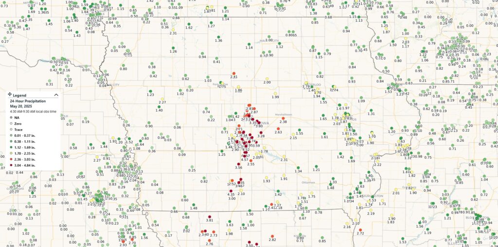
A round of strong thunderstorms moved across Iowa Monday afternoon into early Tuesday morning, delivering widespread heavy rainfall and large hail across much of central and southern Iowa. The storms were driven by a surge of moisture and instability, leading to impressive rainfall totals and several reports of hail over an inch in diameter.

Rainfall Totals
Some of the heaviest rainfall occurred in the Des Moines metro and surrounding areas, where slow-moving storms led to localized downpours. Here’s a breakdown of reported rainfall amounts across the state:
- Des Moines: 2.73″ to 4.52″
- Norwalk: 4.45″
- Waukee: 2.62″ to 3.7″
- Ames: 2.16″ to 3.26″
- Madrid: 2.71″
- Indianola: 2.55″
- Osceola: 2.6″ to 3.46″
- Pella: 2.31″
- Marshalltown: 2.38″
- Eagle Grove: 2.41″
- Iowa Falls: 2.00″
- Fort Dodge: 1.5″ to 1.75″
- Webster City: 1.86″
- Cedar Rapids: 1.87″
- Marion: 1.58″
- Iowa City: 1.64″ to 1.90″
- Davenport: 1.73″ to 2.34″
- Burlington: 1.53″
- Fairfield: 1.48″
- Keokuk: 2.10″
- Oskaloosa: 1.34″
- Mason City: 1.00″
- Cedar Falls: 1.79″
- Waterloo: 1.40″
- Estherville: 1.62″
- Sac City: 1.02″
Hail Reports
In addition to torrential rain, large hail was reported in several communities. Osceola and Knoxville were among the hardest hit, with hailstones reportedly reaching up to the size of golf balls in some locations.
Looking Ahead
While the rainfall helped to ease dry conditions in parts of Iowa, it also led to some localized flash flooding due to the intensity and duration of the storms. More rounds of rain may be possible over the weekend, so stay tuned to the Iowa Storm Chasing Network for the latest updates and alerts.