Severe Storms Rip Through Northern Iowa Overnight, Leaving Behind Damage and Power Outages

Posted: July 28, 2025 | By Iowa Storm Chasing Network
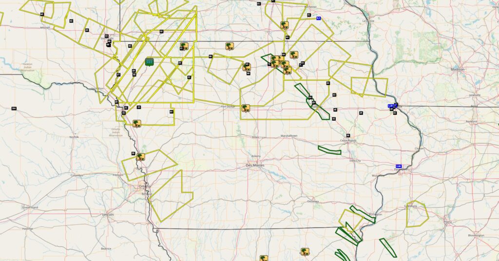
A powerful line of thunderstorms swept across northern Iowa late Sunday night, July 27th, and into the early morning hours of Monday, July 28th, bringing damaging winds and widespread reports of tree and property damage. The storms developed in northwest Iowa and marched southeast through the night, packing wind gusts over 70 mph in some areas and triggering emergency responses across several counties.
Significant Damage Reports
The first signs of damage emerged around 10:45 PM Sunday in Spirit Lake, where a trained spotter reported tree limbs up to 3 inches in diameter snapped, along with a downed tree. As the storms intensified and pushed southeast, communities along the path began to experience similar impacts:
- Forest City (10:57 PM): Public reports indicated downed limbs and corn stalks flattened by strong winds.
- Ledyard (11:26 PM): Several tree limbs were reported down via social media.
- Britt (11:19 PM): A large tree was reported split and blown down.
- 5 Miles North of Mason City (11:30 PM): A trained weather spotter noted numerous large branches down, some at least 3 inches thick.
- Rock Falls & Plymouth (11:26 PM): Large limbs were reported down with a tree landing on a vehicle in Rock Falls, per the Emergency Manager.
- Mason City (11:19 PM): Extensive damage was noted across town, including trees and branches down, trees on vehicles, power poles on fire, and widespread power outages.
- Osage (11:53 PM): Multiple trees were reported down via 911 call center.
- Nora Springs (11:49 PM) & Rockford (11:58 PM): Emergency managers confirmed trees down in both towns.
As the storms moved farther southeast:
- Webster City (12:26 AM): Tree limbs up to 3–4 inches thick were reported down.
- Hornick (1:40 AM): The Woodbury County Emergency Manager reported 4-inch limbs down.
- Boone (1:08 AM): An NWS employee reported several large branches down north of the city.
- Mondamin (3:21 AM): A particularly severe report came in as law enforcement confirmed a roof had been blown off a home.
Notable Wind Gusts
Wind gusts associated with the storms frequently exceeded 60 mph, with some of the strongest readings including:
- Clear Lake (2 ENE): 71 MPH
- Kanawha (5 NNE): 66 MPH
- Ringsted (3 WSW): 66 MPH
- Graton (3 SE): 64 MPH
- Sumner: 64 MPH
- Janesville: 64 MPH
- Britt (4 N): 62 MPH
- Lester (4 E): 62 MPH
- Sioux Center (2 S): 60 MPH
- Waterloo: 59 MPH
- Maurice (2 NE): 58 MPH
- Charles City (5 N): 57 MPH
- Spencer (3 WNW): 55 MPH
- Colwell (2 WNW): 54 MPH
- Oelwein (3 W): 53 MPH
- Dubuque: 52 MPH
- Wahpeton (1 NNE): 51 MPH
- Webb: 51 MPH
- Hiawatha: 50 MPH
- Delhi (4 WSW): 49 MPH
- Independence: 48 MPH
Widespread Impacts
This widespread severe weather event serves as a reminder of the destructive power of summer thunderstorms, particularly when they strike during the overnight hours. From wind gusts over 70 mph to damage reports spanning more than a dozen counties, the impacts were felt far and wide. The Iowa Storm Chasing Network encourages all Iowans to stay weather aware, especially during the peak of severe weather season, and to have multiple ways to receive alerts—day or night.