Posted Friday, August 8, 2025 | Iowa Storm Chasing Network
Overview: Active and Unsettled Weather Pattern
A potent storm system will bring a mix of severe thunderstorms and flash flooding concerns to Iowa this weekend. Multiple rounds of thunderstorms are expected to develop from early Saturday through late Sunday night, with damaging winds, isolated tornadoes, and very heavy rainfall all possible. A stalled frontal boundary combined with deep Gulf moisture and upper-level support will set the stage for a prolonged period of storm activity, especially across central and eastern Iowa.

Timing Breakdown
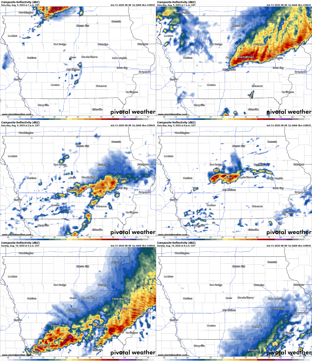
Saturday Morning: Storms may already be ongoing across northern Iowa into Michigan around sunrise. These early storms may weaken some, but isolated clusters could linger into the late morning hours.
Saturday Afternoon: As the atmosphere destabilizes, redevelopment of storms is possible—particularly across eastern Iowa into western Wisconsin. If storms are able to form during this window, damaging wind gusts will be the primary concern. However, uncertainty remains due to potential capping and lingering cloud cover.
Saturday Evening into Overnight: A more organized round of thunderstorms is expected to develop across Iowa as a low-level jet strengthens and interacts with a stalled front. These storms may evolve into small bowing segments capable of producing damaging winds. The bigger concern, however, is the potential for slow-moving and training thunderstorms that could lead to flash flooding during the overnight hours.
Sunday into Monday: The frontal boundary is expected to remain nearly stationary, allowing for additional rounds of rainfall, especially across southern and eastern Iowa. Rain may continue into early next week, with additional waves of precipitation likely through Tuesday.
Severe Weather Threats
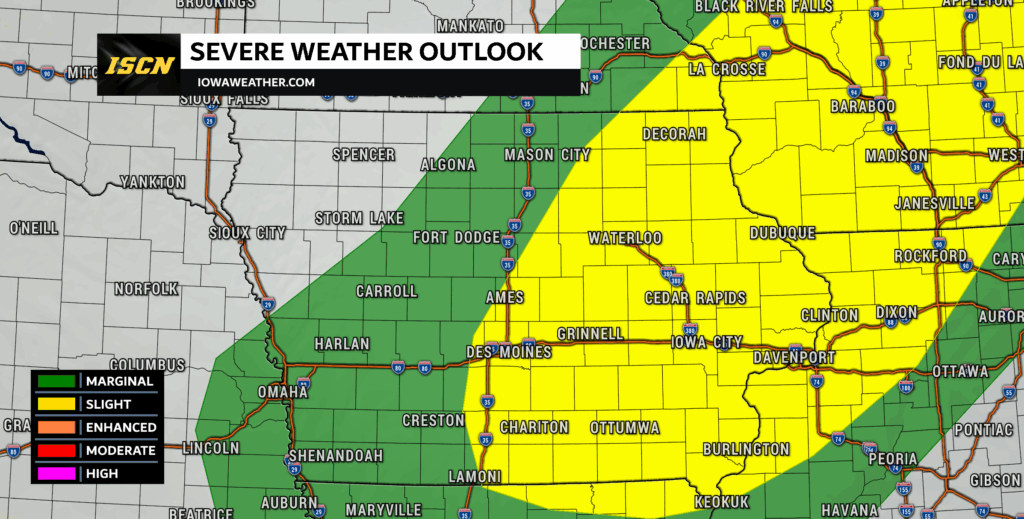
The primary severe threat will be damaging straight-line winds, especially with any organized clusters or bowing segments that form Saturday afternoon and evening. Wind gusts of 60 to 70 mph will be possible. The Storm Prediction Center (SPC) has placed parts of eastern Iowa in a Slight Risk (Level 2 out of 5) for severe weather, with a broader Marginal Risk (Level 1 out of 5) covering central Iowa. There is also a 2% tornado risk from northeast to southwest Iowa. While the tornado potential remains low, it is not zero.

Heavy Rainfall and Flash Flooding Concerns
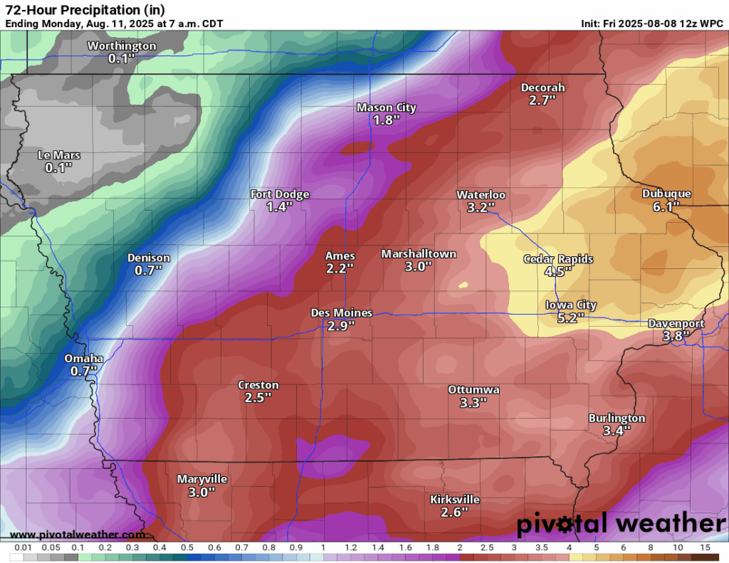
Perhaps the more significant threat this weekend is flash flooding. With a frontal boundary expected to stall across Iowa and a deeply moist atmosphere in place, storms will be capable of producing very heavy rainfall in a short amount of time. Precipitable Water (PWAT) values between 2.0 and 2.3 inches—among the highest levels for this time of year—combined with warm cloud depths over 4 km will lead to efficient rainfall rates. The Weather Prediction Center (WPC) is highlighting a Slight Risk (Level 2 out of 4) for flash flooding both Saturday and Sunday across the southeastern half of the state, particularly in central and eastern Iowa. Rainfall rates of 1 to 3 inches per hour are possible, with total accumulations of 3 to 6 inches not out of the question in some areas. Localized higher amounts may occur where storms repeatedly pass over the same locations.
Stay Weather-Aware
Forecast confidence remains low regarding exact storm placement and intensity due to uncertainties in capping and early-day convection. However, the ingredients are in place for both severe weather and significant rainfall impacts. With multiple rounds of storms likely, those in flood-prone or low-lying areas should be especially cautious. Be sure to monitor river levels and avoid driving through flooded roadways.
We encourage all Iowans to stay updated by following the Iowa Storm Chasing Network on Facebook and downloading the ISCN Weather App. With real-time radar, push alerts, and live chaser updates, you’ll have the tools you need to stay ahead of the storm.