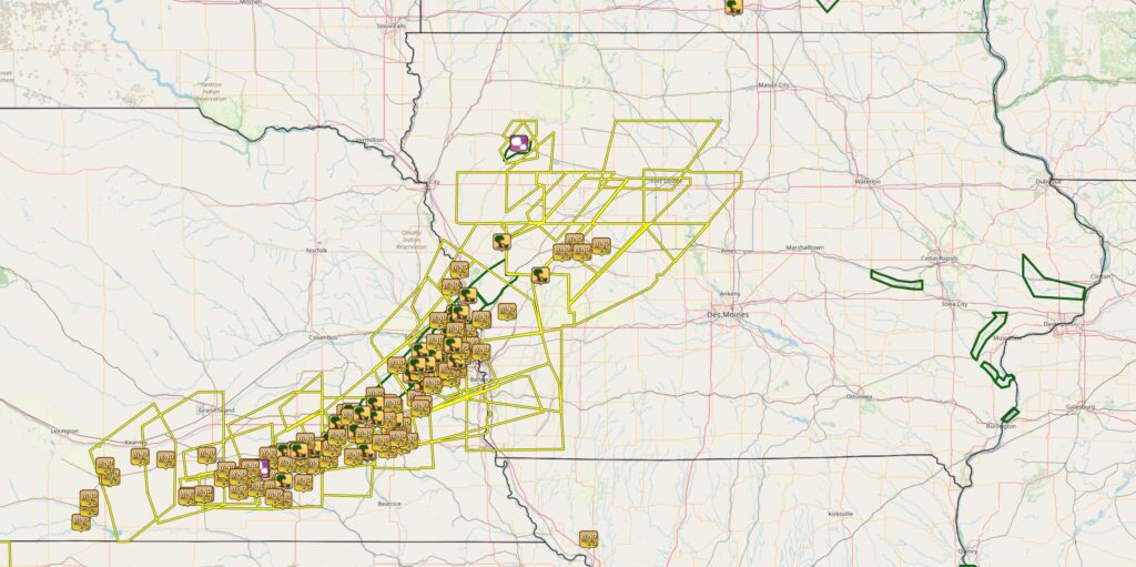
Damaging Thunderstorms Sweep from Central Nebraska into Western Iowa Early Saturday

August 9, 2025 – A powerful complex of thunderstorms tracked from central Nebraska into western Iowa early Saturday morning, producing destructive winds, torrential rainfall, and flooding in several communities. The storms originated near Kearney, Nebraska, just before 2 a.m., and quickly intensified as they raced northeast.
The first damaging wind reports came in from central Nebraska shortly before 2 a.m., with the line reaching the Lincoln metro area around 5 a.m. and later impacting Omaha and surrounding communities before weakening in western Iowa between 7 and 9 a.m.
Peak Wind Gusts
The National Weather Service received numerous reports of severe wind gusts, many exceeding 80 mph. Among the strongest measured:
- 3 miles SSE of Fairmont, NE – 91 mph at 4:12 a.m.
- 2 miles NE of Exeter, NE – 86 mph at 4:26 a.m.
- Friend, NE – 84 mph at 4:25 a.m.
- 4 miles ESE of Raymond, NE – 84 mph at 5:22 a.m.
- 1 mile SSE of Blair, NE – 86 mph at 6:24 a.m.
- 3 miles NE of Boys Town, NE – 83 mph at 6:04 a.m.
- 2 miles S of Milford, NE – 80 mph at 4:45 a.m.
- 4 miles N of Gretna, NE – 80 mph at 5:54 a.m.
- 3 miles SSW of Blencoe, IA – 73 mph at 6:45 a.m.
- Halbur, IA – 70 mph at 7:38 a.m.
Damage Reports
The wind left a trail of destruction across dozens of communities:
- Ithaca, NE – Barn destroyed.
- Mead, NE – Porch roof torn off.
- Leshara, NE – Home with broken windows.
- Bennington, NE – Shed destroyed.
- Washington, NE – Power lines down and significant tree damage.
- Kennard, NE – Siding ripped off garage.
- Blair, NE – Roof collapse, camper blown over, numerous reports of severe structural and tree damage.
- Mondamin, IA – Large tree uprooted.
- Arcadia, IA – Damage to sheds and outbuildings.
- Swan Lake State Park (Carroll, IA) – Large trees down.
Flooding Impacts
Heavy rainfall accompanied the damaging winds, causing flooding in multiple locations. In Blair, Nebraska there was a report of 6 to 10 inches of moving water rushing through an apartment complex parking lot, along with reports of backyards submerged under 3 to 5 feet of water. Flooding was also observed along Cauble Creek.
Timeline of Key Reports
- ~1:55 a.m. CDT: First wind damage reports in central Nebraska.
- 4:12 – 4:53 a.m.: Numerous 80–91 mph gusts in Fairmont, Exeter, Friend, and Seward areas.
- 5:00 – 5:30 a.m.: 80–84 mph gusts impact Lincoln metro and surrounding communities.
- 6:00 – 6:30 a.m.: Severe winds batter Omaha metro and into Blair.
- 7:00 – 7:45 a.m.: Storms enter western Iowa with winds of 70–73 mph before weakening.
Saturday morning’s storms were a vivid reminder of how quickly severe weather can develop and the widespread impacts it can have across the Plains. With winds topping 90 mph, the event caused significant tree and structural damage, widespread power outages, and localized flooding from torrential rain.