Strong Storms Batter Northern and Eastern Iowa Friday

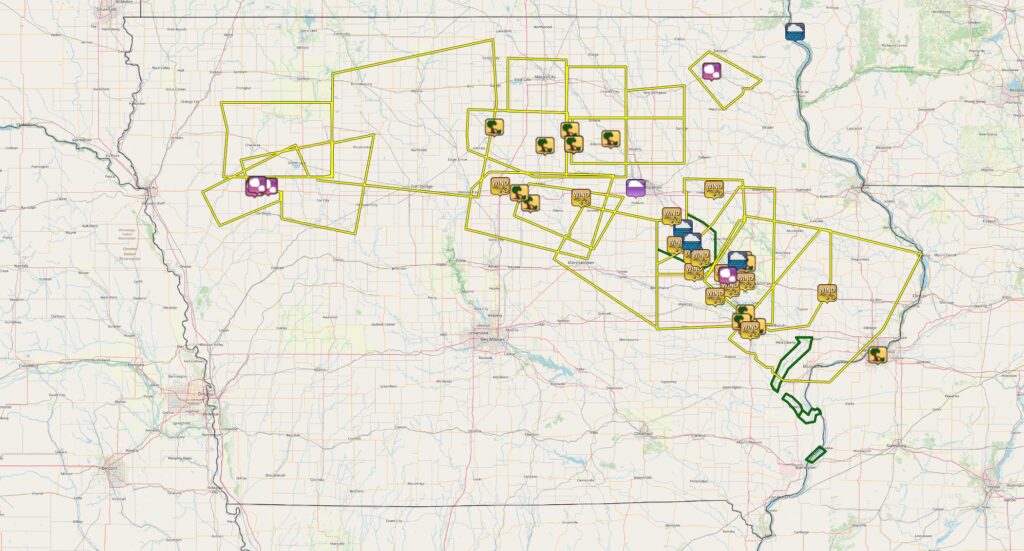
A potent severe weather event swept across northern and eastern Iowa on Friday, August 15, bringing large hail, damaging winds, and even a lightning-caused fire. The storm originated near sunrise in central Nebraska, developing around 6 a.m. and prompting severe thunderstorm warnings by 7:26 a.m. in northeast Nebraska. Early reports from that region included hail ranging from 0.5 inches to 1.25 inches in diameter. The final Nebraska warning was issued at 9:41 a.m. before the storm weakened briefly as it entered northwest Iowa around 10 a.m. By 11:30 a.m., however, the storm had restrengthened, triggering a new round of warnings.
Hail Hits First in Northwest Iowa
In the midday hours, hail was the primary hazard. Holstein reported 1.5-inch hail at 12:12 p.m. and 1-inch hail at 1:20 p.m., while Galva logged 0.88-inch hail at 12:31 p.m. As the storm grew and organized into a line by the 2 p.m. hour, the threat shifted toward damaging straight-line winds.
Winds Increase Along the I-35 Corridor
Belmond saw trees down at 2:05 p.m., and a personal weather station near Williams clocked a 56-mph wind gust. Hampton reported trees and power lines down around 2:30 p.m., while Alden saw 6- to 8-inch branches down, flattened bean crops, and pea-sized hail. Near Buckeye around 4 p.m., trees were down at a campground, a camper was blown off its blocks, a large limb fell on a truck, and a metal shed sustained door damage.
Cedar Valley and I-380 Corridor See Peak Gusts
Additional wind damage followed across the region. Wellsburg recorded a 56-mph gust at 4:07 p.m., while Aredale and Dumont each reported trees down around 2:40 p.m. Clarksville saw a tree down in town at 3:05 p.m. In Cedar Falls at 4:45 p.m., the fire department responded to a lightning strike that created a hole in a roof and left smoldering material in the attic. Wind speeds increased further into the Cedar Valley and I-380 corridor, with La Porte City and East Amana both reporting 72-mph gusts. Garrison reached 60 mph, Vinton 59 mph, Newhall 58 mph, and Shellsburg 64 mph. Marion recorded a 70-mph gust along with large branches down and dime-sized hail, while the Eastern Iowa Airport in Cedar Rapids saw a 71-mph gust. Fairfax recorded 60 mph, and Ely topped out at 65 mph.
Significant Impacts in Johnson County
In Johnson County, Iowa City measured a 69-mph gust and reported numerous tree branches down up to six inches in diameter. University Heights saw a tree about 1.5 feet in diameter fall on Melrose Avenue at Mormon Trek. North Liberty reported trees 2 to 2.5 feet in diameter down around 6:06 p.m., while Coralville had large limbs blocking roadways.
Final Impacts to the East
Farther east, Lowden measured a 60-mph gust at 6:17 p.m., and in Moline, Illinois, a large tree was photographed down on power lines at 7:05 p.m.
A Long-Lived, Multi-Hazard Event
The storm’s evolution showcased a classic summertime transition: starting with hail in northwest Iowa before morphing into a fast-moving line that delivered destructive winds from the I-35 corridor through Cedar Rapids, Iowa City, and into the Quad Cities. Peak measured gusts reached 72 mph in multiple locations, and damage reports were widespread. From downed trees and crop damage to structural impacts and a lightning-related fire, August 15 was a reminder of how quickly severe weather can escalate and how long-lived thunderstorm systems can leave a swath of hazards across the state.