Several areas of Iowa are dealing with showers and thunderstorms Monday morning as an area of precipitation continues moving east and southeast across the region. The activity is scattered, meaning not everyone will receive meaningful rainfall, but enough showers are present that calling the morning dry would be misleading. Some thunderstorms may also produce brief heavier downpours before weakening as they move farther into Iowa. The primary source of moisture feeding the morning activity remains displaced to the west and northwest, while considerably drier air is waiting farther east. That should eventually work against the showers and cause coverage and intensity to decrease as Monday progresses.
Some locations may experience intermittent rain into late morning or early afternoon, while nearby communities remain completely dry. Even where rain continues, widespread severe weather is not expected with Monday morning’s activity. Lightning and brief heavier rainfall are possible with the stronger thunderstorms, so anyone with outdoor activities should continue monitoring the weather radar until the showers move through. Conditions should remain generally quiet Monday night before the next system approaches Tuesday.
Tuesday Cold Front Brings Another Chance for Thunderstorms
A cold front moving southeast through the Upper Midwest will bring Iowa’s next chance for thunderstorms Tuesday. Storms may initially develop near northern Iowa during the morning, but the better opportunity for stronger storms should come later in the afternoon and evening as the atmosphere becomes more unstable. Warm temperatures and increasing humidity will provide fuel for thunderstorms ahead of the front, especially across northwest Iowa. At the same time, winds several thousand feet above the ground will be strong enough to help any sustained thunderstorms become organized. The biggest question is whether enough storms can actually break through a layer of warmer air aloft that may act like a lid on the atmosphere. Because of that uncertainty, Tuesday could range from only isolated thunderstorms in Iowa to a somewhat more active afternoon if that cap weakens.
The strongest large-scale forcing with this system is expected to pass north of Iowa through Minnesota and Wisconsin. That lowers confidence in widespread thunderstorms across the state and is one reason rain chances have generally trended downward. Moisture availability is another concern because thunderstorms farther west across Nebraska could intercept some of the richer Gulf moisture before it reaches Iowa. If that occurs, central Iowa may remain relatively dry even as the front moves through. Northwest Iowa has a better chance of being closer to the deeper moisture and stronger instability during the afternoon. Forecast confidence is moderate regarding the overall pattern but lower on exactly where individual storms will develop.
Isolated Severe Storms Possible Tuesday
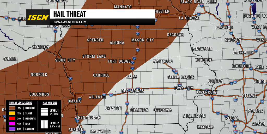
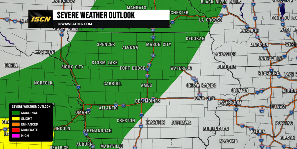
Portions of northwest and central Iowa are in a Marginal Risk, Level 1 of 5, for severe thunderstorms Tuesday. This means isolated severe storms are possible, but a widespread or particularly significant severe weather event is not currently expected. Any storm that can become established may encounter roughly 30 to 35 knots of deep-layer wind shear, which is enough to support an organized strong storm. Damaging wind gusts and large hail are the primary severe weather threats based on the current forecast. The tornado threat appears low with the information currently available, although any thunderstorm that becomes severe should still be monitored closely. Residents should continue checking weather radar and weather alerts Tuesday because the exact placement of storms may not become clear until the atmosphere begins to destabilize.
Quiet Weather Returns Wednesday and Thursday
A surface area of high pressure will move across the region behind Tuesday’s cold front, bringing quieter weather back to much of Iowa Wednesday. Any lingering showers associated with Tuesday’s system should end early, especially across western and central Iowa. Eastern Iowa may hold onto a chance for showers or thunderstorms into Wednesday morning as the upper-level disturbance moves toward the Great Lakes. Some instability and moderate wind shear could support an isolated stronger storm in eastern Iowa, although coverage and the overall severe threat look limited. Most of the state should then experience dry weather for a substantial portion of Wednesday and Thursday. Confidence is fairly high in a calmer midweek period once the cold front clears the region.
High temperatures should generally remain in the lower to middle 80s Wednesday and Thursday, which is close to normal for late August. Humidity may briefly decrease behind the front before beginning to climb again later in the week. The upper-level pattern will still feature a large ridge of hot air centered well southwest of Iowa rather than directly over the state. That should prevent significant heat from reaching most of Iowa during the middle of the week. Wednesday currently looks like one of the best days for outdoor plans, especially across western and central Iowa. Eastern Iowa may need to allow extra time for early showers before improving later in the day.
Thunderstorm Chances Increase Again Late Week and This Weekend
The weather pattern becomes more active again from Friday into the weekend as the upper-level winds flatten and begin carrying multiple disturbances through the Midwest. Rain and thunderstorm chances may return to western Iowa as early as Thursday night or Friday before expanding across more of the state. Friday currently appears to have one of the better opportunities for precipitation, especially across western portions of the region. Additional rounds of thunderstorms are possible Saturday, Sunday, and perhaps into early next week. The exact timing of each disturbance remains uncertain because weather models disagree on how quickly individual waves will move through the pattern. This means there should still be plenty of dry hours during the weekend even though rain chances may appear in the forecast on several consecutive days.
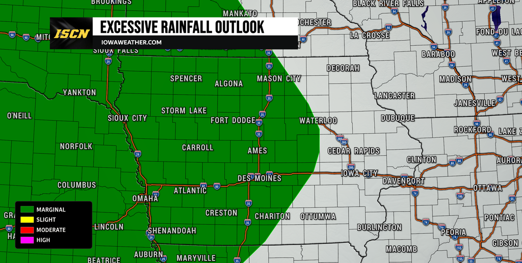
Moisture flowing north from the Gulf could become more substantial by Friday. A strengthening low-level jet of roughly 30 to 45 knots may transport that moisture into the northern Plains and Upper Midwest, creating the potential for locally heavy rainfall somewhere in the region. Current guidance suggests an excessive rainfall risk could eventually develop across portions of the Upper Midwest or northern Plains Friday, but it is too early to determine whether the greatest threat will extend into Iowa. The location of the warm front and the track of individual thunderstorm complexes will be critical. If storms repeatedly move across the same area, localized heavy rainfall could become a concern. Confidence is increasing that the pattern will become wetter and more active, but confidence remains low on exact rainfall amounts or which Iowa communities will receive the most rain.
Temperatures Gradually Climb Toward the Weekend
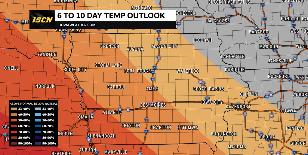
Seasonable temperatures will dominate much of the work week, with afternoon highs generally ranging from the upper 70s to middle 80s. Monday will be coolest in areas where morning clouds linger the longest, while Tuesday should turn warmer ahead of the approaching cold front. Temperatures settle back into the lower and middle 80s Wednesday and Thursday before gradually climbing again late in the week. By Sunday and Monday, portions of Iowa could reach the middle or upper 80s, with some hotter readings possible nearby in the central Plains. Increasing humidity may make it feel warmer as deeper Gulf moisture returns.
Long-range weather guidance does favor warmer-than-normal conditions becoming more established around the beginning of September. Areas immediately west of Iowa may have a greater chance of reaching the 90s as the Plains warm under the broader upper-level ridge. How far east that hotter air reaches will depend on the position of the ridge and the frequency of thunderstorms moving through Iowa. Repeated storm systems could keep temperatures somewhat lower, while longer dry periods would allow more heat to build. This remains a lower-confidence part of the forecast because it extends beyond the more predictable short-term weather pattern.
IowaWeather.com will continue tracking Tuesday’s severe weather potential, weekend rain chances, changing temperatures, and any adjustments to the local weather forecast. Check back for updated forecasts, live weather radar information, and the latest severe weather alerts as new data becomes available.