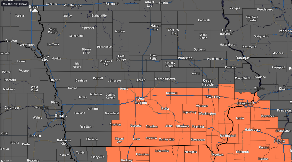
Summer is not ready to give up on Iowa just yet. A stretch of increasingly hot and humid weather will settle across much of the state this week, with southern Iowa facing the greatest heat concerns as afternoon heat index values climb to around 100 degrees. Temperatures will generally reach the upper 80s and 90s, while high humidity will make it feel several degrees hotter. The combination of hot afternoons and warm nights will make this a prolonged heat event rather than just a single uncomfortable day. Some parts of southern Iowa are already under a Heat Advisory through Wednesday afternoon.
Thunderstorm chances will also remain in the Iowa weather forecast, but rain will not be widespread or continuous. A weak front wavering across the state will provide occasional opportunities for storms, especially across northern Iowa and near the Iowa-Minnesota border. Most locations could go long stretches without rain, and many areas may remain completely dry on Monday and much of Tuesday. The more organized opportunity for thunderstorms arrives Tuesday night, when a disturbance moving through the Upper Midwest could help storms develop near the frontal boundary. A few storms could become strong or severe, although where that boundary ultimately sets up will have a major influence on which parts of Iowa are affected.
Heat and Humidity Build Across Iowa
Heat will be the most widespread weather concern across Iowa through at least the middle of the week. Southern Iowa is expected to see highs mainly in the lower to middle 90s Monday through Wednesday, with dew points high enough to push the heat index to around 100 degrees during the afternoon and early evening. Eastern and southeastern Iowa will also experience heat index values generally in the middle 90s to around 100, particularly south of Interstate 80. Northern Iowa will still be warm, but a nearby frontal boundary should keep temperatures somewhat lower and may occasionally bring less humid air into the region. Confidence is high that southern Iowa will experience several consecutive days of above-normal temperatures.
The duration of the heat is also important because nighttime temperatures will provide limited relief in some areas. Overnight lows could remain in the 70s, with portions of eastern and southwestern Iowa potentially struggling to fall much below the middle 70s later this week. When temperatures remain warm overnight, homes without effective air conditioning have less opportunity to cool down before the next hot afternoon begins. Anyone working outside, attending practices, spending time at fairs or outdoor events, or participating in school activities should plan for frequent water and cooling breaks. The heat index is a measure of how hot the combination of temperature and humidity feels to the human body, and it can become dangerous with extended exposure even when the actual temperature remains below 100 degrees.
Will It Rain in Iowa Today?
Most of Iowa will not see widespread rain Monday, and many communities are likely to remain dry throughout the day. A weak front will settle southward into the state and eventually become nearly stationary, stretching somewhere from southwest Iowa through central Iowa and toward the northeast. Moisture and atmospheric instability will be available near this boundary, meaning an isolated thunderstorm could develop during the afternoon or evening. However, warm air several thousand feet above the ground will act like a cap on the atmosphere and make storm development difficult. There is also little large-scale lift available to force thunderstorms to form.
Because of those limiting factors, the chance of rain today remains low in most locations. Northwestern Iowa could see a few sprinkles or light showers during the morning, but rainfall amounts should be minor. Isolated thunderstorms are also possible farther east and northeast during the afternoon, especially near and north of Highway 30, but coverage should remain limited. If one of these storms manages to become established, enough instability will be present for gusty winds or hail, particularly across northern and northeastern Iowa. The severe weather threat is therefore conditional, meaning the atmosphere could support a stronger storm but there may not be enough forcing to actually produce many thunderstorms.
Tuesday Brings a Better Chance for Strong Storms
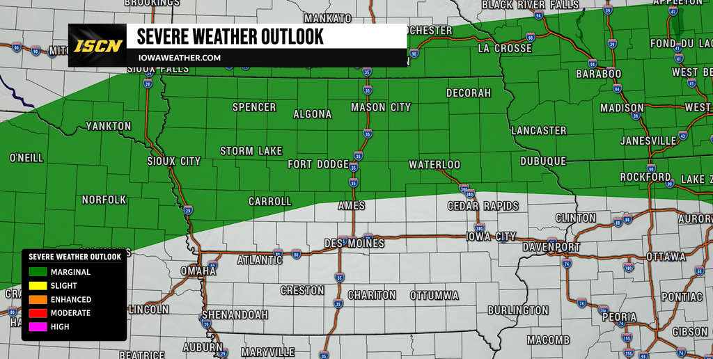
Tuesday will start mainly dry across much of Iowa after any early morning storms in the northwest fade or move away. The stalled front is expected to begin lifting northward as a warm front, allowing hot and humid air to spread farther north during the day. At the same time, a stronger disturbance will move from the Rockies into the Northern Plains and Upper Midwest. That system should provide more support for thunderstorms by Tuesday evening and Tuesday night than Iowa will have Monday. The highest storm chances appear to be across northern Iowa, although exactly how far north the warm front moves remains uncertain.
The atmosphere near the front could become quite unstable, with forecast guidance indicating enough energy and wind shear to support organized thunderstorms if storms develop. That would create a risk for damaging wind and hail, especially from eastern Nebraska into portions of northern and western Iowa before storms track eastward. The overall severe weather risk remains limited because thunderstorm coverage may remain scattered, and some forecast models keep the strongest activity north of Iowa altogether. This is an important distinction: Tuesday has a more favorable environment for severe weather, but it does not currently look like a widespread Iowa severe weather outbreak. Residents across northwest and northern Iowa should pay closer attention to forecast updates Tuesday as the eventual position of the front becomes clearer.
When Will Thunderstorms Arrive?
The most likely window for more organized thunderstorms appears to be Tuesday evening into Tuesday night. Storms may first develop farther west over Nebraska during the late afternoon and evening before spreading east toward the Missouri River and northern Iowa. Additional thunderstorms could form along the warm front overnight as stronger winds just above the surface transport moisture into the region. This setup favors clusters of thunderstorms rather than one solid line crossing the entire state. Northern Iowa currently has the better chance of receiving measurable rain, while southern Iowa may see very little rainfall.
Storm timing remains somewhat uncertain because even small changes in the location of the warm front could shift the main thunderstorm corridor by dozens of miles. Some forecast guidance places the boundary well into northern Iowa, while other solutions keep it closer to Highway 20 or even farther south toward Interstate 80. If the front remains farther south, more of Iowa could experience storms Tuesday night. If it moves north more quickly, the heaviest and strongest storms could favor Minnesota and far northern Iowa instead. Forecast confidence is therefore moderate that storms will occur somewhere in the region Tuesday night but lower regarding exactly which Iowa communities receive the most rain.
Heat Index Near 100 Through Midweek
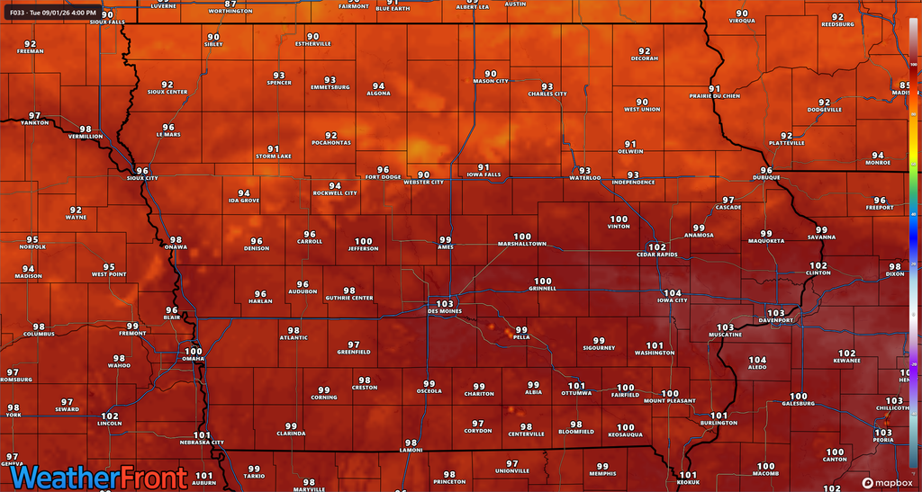
Tuesday and Wednesday are likely to be among the hottest days of the week for much of Iowa. High temperatures will commonly reach the 90s across central and southern Iowa, while humidity pushes the heat index into the upper 90s and locally around or above 100 degrees. Southwest Iowa, south-central Iowa and southeast Iowa should experience the most persistent heat because these areas are more likely to stay south of the frontal boundary. Eastern Iowa south of Interstate 80 will also be vulnerable to several afternoons of uncomfortable and potentially dangerous heat. Cloud cover or thunderstorms could briefly lower temperatures farther north.
People searching for the heat index today or the temperature forecast this week should keep in mind that humidity will be almost as important as the actual air temperature. Dew points in the upper 60s and lower 70s will make it difficult for sweat to evaporate efficiently, which reduces the body’s ability to cool itself. Outdoor workers and athletes should take extra precautions during the hottest part of the afternoon, especially between roughly midday and early evening. Children, older adults and people without reliable air conditioning can also be more vulnerable during a multi-day heat wave. The lack of significant overnight cooling could gradually increase heat stress as the week continues.
Warm Weather Continues Late This Week
The overall weather pattern is not expected to change quickly after Wednesday. A large ridge of high pressure in the upper atmosphere will remain positioned near the central and eastern United States, keeping Iowa on the northern edge of the hottest air. Weak disturbances traveling around the edge of that ridge could continue to produce occasional rain and thunderstorm chances across northern Iowa Wednesday and Thursday. Those chances currently appear scattered rather than widespread, meaning the week is unlikely to feature prolonged periods of rain. Southern Iowa has the greatest chance of remaining both hotter and drier.
Temperatures should stay above normal for much of the state through the end of the workweek. There are indications that the upper-level ridge could strengthen again over the Plains toward next weekend, which could push the main storm track farther north and reduce Iowa’s rain chances. If that occurs, more widespread 90-degree temperatures may continue or return across the state. Exactly how humid conditions become later in the week is less certain because surface wind direction and frontal placement will determine how much moisture remains over Iowa. Confidence is higher in continued warmth than in the exact temperature, humidity and rainfall forecast for next weekend.
Stay with IowaWeather.com for the latest Iowa weather forecast, severe weather updates and changes to storm timing throughout the week.