Tuesday will be an active weather day across Iowa as a cold front moves through a hot and increasingly humid air mass. Thunderstorms are already affecting portions of northern and western Iowa this morning, but a more organized round of storms is expected to develop later this afternoon and continue into tonight. Central and eastern Iowa will have the greatest potential for severe weather and locally heavy rainfall.
Before the storms arrive, temperatures will surge into the 90s across much of central and southern Iowa. Combined with higher humidity, the heat index could approach or briefly exceed 100 degrees in some areas. The cold front will eventually bring relief, with temperatures falling back closer to normal beginning Wednesday and continuing through much of the remainder of the week.
Thunderstorms Increase Across Iowa Today
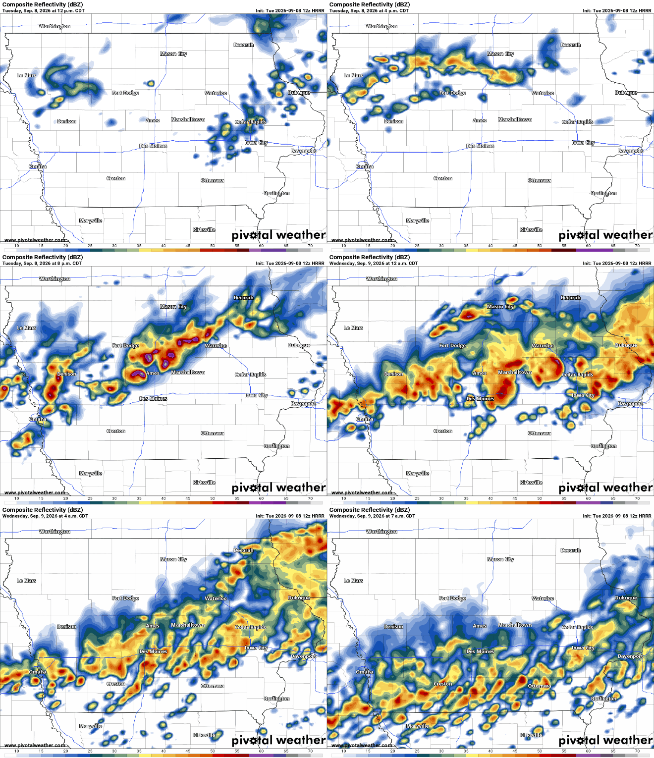
Several areas of thunderstorms are already moving through northern and western Iowa this morning as warm, humid air flows northward across the region. Some of these storms could produce frequent lightning, brief strong wind gusts and locally heavy rain, especially across northwest and northeast Iowa. The morning activity should become less organized later in the morning or around midday as the atmospheric setup temporarily becomes less favorable for storms. That break will be important because sunshine behind the morning clouds could allow the atmosphere across central and southern Iowa to become much more unstable. A cold front moving southeast through the state will then provide the trigger for another round of thunderstorms during the afternoon and evening. Confidence is high that thunderstorms will affect a large portion of Iowa today, although the exact placement of the heaviest storms will depend partly on how quickly the atmosphere recovers from this morning’s activity.
For anyone checking the weather today, rain will not necessarily last throughout the entire day at any one location. Instead, Iowa will likely see multiple rounds of showers and thunderstorms with breaks in between. Storm development should increase during the mid to late afternoon across central Iowa before expanding southeastward during the evening. Western Iowa should gradually dry out behind the front tonight, while storms may continue longer across central, southern and eastern Iowa. Some rain could linger into Wednesday morning across southeastern Iowa before the system finally exits. Residents should keep an eye on weather radar and changing conditions, especially during the late afternoon and evening.
Severe Weather Possible This Afternoon and Evening
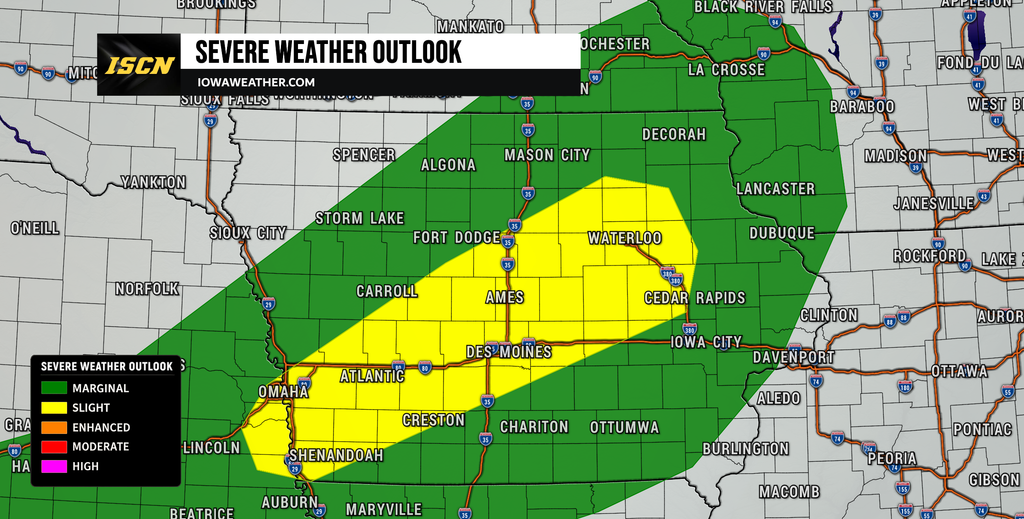
A few thunderstorms could become severe as they develop along the cold front this afternoon and evening, with the greatest concern across portions of central Iowa. The atmosphere could contain roughly 2,000 to 3,000 joules per kilogram of instability where enough sunshine occurs, providing storms with plenty of energy to strengthen quickly. Wind patterns higher in the atmosphere should provide enough organization for some stronger storms, although the setup favors storms eventually merging into lines or clusters rather than remaining isolated for long periods. Damaging wind gusts are the primary severe weather hazard, particularly as storms encounter the hot and well-mixed air ahead of the front. Large hail is also possible with the stronger thunderstorms, especially early in the development process before storms grow together. Confidence in at least scattered strong storms is moderate, while confidence in exactly which communities experience severe weather remains lower.
The most favorable window for severe thunderstorms should begin during the mid to late afternoon and continue through much of the evening. Portions of western Iowa could see stronger storms first before the focus shifts into central and eventually eastern Iowa. Storms developing near the front could intensify rapidly, so conditions may change quickly even where skies remain quiet earlier in the day. The strongest wind gusts could potentially reach severe levels of 60 mph or higher, while hail around quarter size or larger cannot be ruled out in the most intense storms. Not every thunderstorm will become severe, and widespread destructive weather is not expected based on the current forecast. Still, anyone with outdoor activities planned this afternoon or evening should have a way to receive weather alerts if a warning is issued.
Heavy Rain and Flash Flooding Could Become a Concern
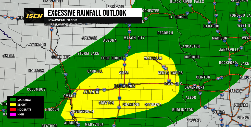
Heavy rainfall may become just as important as the severe weather threat tonight, particularly across central and eastern Iowa. Atmospheric moisture will increase dramatically ahead of the front, with moisture levels near the upper end of what is normally observed in Iowa during early September. That means thunderstorms will be capable of producing very heavy rain over relatively short periods. Most areas affected by storms should receive roughly 0.5″ to 1.5″ of rain, but a corridor of 2″ to 4″ could develop where thunderstorms repeatedly move across the same locations. Isolated totals above 4 inches cannot be ruled out if several intense storms train over one area, although those amounts should not be widespread. Confidence is moderate that pockets of heavy rainfall will occur, but the exact placement of the highest totals remains uncertain.
Central and eastern Iowa appear to have the greatest risk for repeated thunderstorms tonight, with particular concern extending into portions of eastern Iowa west of Highway 218. The cold front will continue moving, which should prevent a widespread major flooding event, but its movement could temporarily slow enough for storms to follow similar paths. Urban areas, poor-drainage locations and roads that commonly collect water will be the most vulnerable to short-term flooding. Eastern Iowa has experienced relatively dry soil conditions recently, which should help absorb some rainfall at first, but intense rain rates can still overwhelm drainage systems. Travelers tonight should never attempt to drive through flooded roads because water depth can be difficult to determine after dark. Anyone checking the rain forecast should understand that rainfall amounts could vary considerably over relatively short distances.
Heat and Humidity Build Before the Cold Front
Before the thunderstorms arrive, Tuesday afternoon will feel more like midsummer across central and southern Iowa. High temperatures should climb into the low and middle 90s in many locations south of northern Iowa, while southwest Iowa could reach the middle to upper 90s. Dew points rising into the upper 60s and 70s will make the air feel considerably more humid than the actual temperature suggests. The heat index today could reach around 100 degrees across central and southern Iowa, with a few locations briefly approaching 105 degrees. The hottest conditions should generally occur along and south of Interstate 80 before clouds and thunderstorms increase later in the day. Confidence in the heat is high, although the exact peak temperature will depend on how quickly morning clouds clear.
Areas near the Missouri River in southwest Iowa could experience some of the highest apparent temperatures, with heat index readings potentially reaching the 104 to 108 degree range. Farther north, morning thunderstorms and cloud cover should limit heating, keeping many locations in the 80s. Anyone working or exercising outdoors should take additional breaks and drink plenty of water during the afternoon. The combination of heat and humidity will also help provide fuel for thunderstorms once the cold front arrives. Temperatures will fall quickly in areas where storms develop, followed by a more comfortable air mass behind the front. This will be the final day of significant heat for much of Iowa before a noticeable pattern change.
Cooler and Less Humid Weather Arrives Wednesday
The cold front responsible for today’s storms will also bring a significant improvement in temperatures and humidity. Highs Wednesday should generally settle into the upper 70s and lower 80s across much of Iowa, although eastern and southeastern sections may remain cloudy or rainy during the first half of the day. Northwest winds behind the front will gradually pull drier air into the state, making conditions feel much more comfortable than Tuesday. Most of western and central Iowa should be dry by Wednesday morning, with remaining rain shifting out of eastern Iowa by later in the day. Wednesday night should also feel cooler, with overnight temperatures falling into the 50s in many locations. Confidence in the cooler and quieter Wednesday weather forecast is high.
Thursday should offer another largely quiet day as high pressure settles across the Upper Midwest. Temperatures around 80 degrees will be common, which is much closer to normal for early September than the recent stretch of hotter weather. Humidity should remain relatively low, and mostly sunny to partly cloudy skies are expected across much of the state. These conditions should make Thursday one of the more comfortable days of the week for outdoor activities and travel. The dry period will not last indefinitely, however, as another weather disturbance approaches Iowa toward Friday and Saturday. For residents looking at weather tomorrow, Wednesday will mark a clear transition away from Tuesday’s heat, humidity and thunderstorms.
Rain Chances Return Heading Into the Weekend
Another round of showers and thunderstorms could reach Iowa late Friday into Saturday as a fast-moving disturbance crosses the region. Temperatures may briefly climb again ahead of that system Friday, especially across western Iowa where some areas could return to the upper 80s or possibly warmer. Moisture will increase ahead of the approaching cold front, allowing another band of showers and thunderstorms to develop. Current guidance supports a meaningful chance for rain, but this system appears faster-moving than Tuesday’s front, which may limit rainfall totals. There is not enough confidence yet to determine whether severe weather will become a concern with the Friday night or Saturday storms. Forecast details should become clearer as higher-resolution weather models move into range over the next few days.
Another weather system may follow during the second half of the weekend or early next week, keeping Iowa in a more active pattern. Forecast guidance agrees fairly well that cooler air should eventually spread across the region behind these systems, but there is greater disagreement on the exact timing of each front and round of rain. Some northern portions of the region could struggle to reach 70 degrees by Sunday or early next week if the cooler solutions verify. Other areas may remain in the 70s to low 80s depending on the speed and track of the systems. This makes the broader cooling trend more certain than the day-to-day precipitation timing. Anyone making weekend plans should continue checking the weather forecast for the week as the timing becomes better defined.
Stay with IowaWeather.com for the latest Iowa weather updates, interactive radar, severe weather information and changes to the forecast as thunderstorms develop across the state today and tonight.