The Great Iowa Flood of 1958: The Night More Than a Foot of Rain Fell in Western Iowa
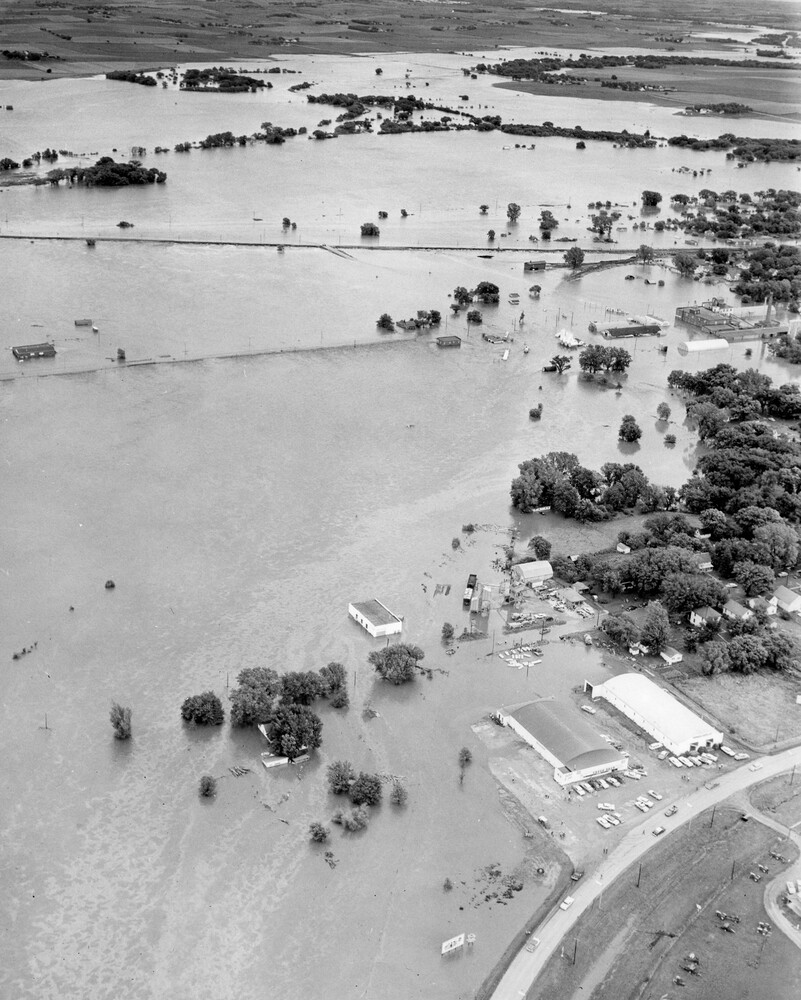
During the early morning hours of July 2, 1958, one of the deadliest flash floods in Iowa history swept through western Iowa.
An extraordinary thunderstorm dumped more than a foot of rain near Audubon in less than 24 hours. Creeks and rivers rapidly escaped their banks, floodwaters swept through communities while many residents were sleeping, and parts of the East Nishnabotna River basin were devastated.
The communities of Audubon, Hamlin, Exira, Brayton, Atlantic and Red Oak were among those hit by the flooding. Exira suffered some of the worst destruction.
By the time the water receded, at least 18 people had been killed, millions of dollars in damage had occurred, and the flood had become one of Iowa’s most significant weather disasters of the 20th century. Historical sources differ slightly on the final death toll, with some federal records reporting 19 fatalities.
An Extraordinary Rainstorm Develops Over Western Iowa
The disaster began with thunderstorms during the night of July 1 into July 2, 1958. These weren’t ordinary summer thunderstorms. An intense thunderstorm complex developed over the headwaters of the East Nishnabotna River basin and produced tremendous rainfall in a relatively short period.
At Audubon, an official observer recorded 12.53 inches of rain during the 24 hours ending July 2. According to historical U.S. Geological Survey records, it was the second-highest official 24-hour rainfall total recorded in Iowa between 1844 and 1981.
For perspective, the USGS noted that 12.53 inches was nearly twice the amount associated at the time with a 100-year, 24-hour rainfall event in the Audubon area. An unofficial observation in the Audubon area was even higher, measuring 13.23 inches. In other words, parts of western Iowa received roughly an entire season’s worth of rainfall in a matter of hours.
Why Did the Flood Become So Dangerous?
The enormous rainfall totals were only part of the story. Much of the rain fell across relatively small streams and tributaries feeding into larger waterways, including the East Nishnabotna River.
As torrential rain continued, runoff poured into creeks and streams faster than the water could be carried downstream. Small waterways rapidly transformed into violent torrents. This is what makes flash flooding especially dangerous.
Unlike flooding along a major river that may take days to develop, a flash flood can develop in minutes or hours. Water levels can rise dramatically before people downstream fully understand what is happening. That was particularly dangerous in 1958.
There were no smartphones, Wireless Emergency Alerts, modern weather radar networks or automated flash flood warnings capable of instantly reaching thousands of people. And this flood struck during the night. Many residents were asleep as the water began rising.
A Wall of Water Moves Down the East Nishnabotna Basin
As runoff entered the East Nishnabotna River and its tributaries, water levels rose with extraordinary speed. The U.S. Geological Survey later described the July 2–7 flooding in southwestern Iowa as record-breaking. Peak stages and streamflows on numerous smaller waterways reached or exceeded previously known floods.
Communities along the East Nishnabotna River were suddenly in the path of the rising water. Audubon, Hamlin, Exira, Brayton, Atlantic and Red Oak were particularly hard hit.
Flooding also affected portions of the Raccoon River basin, including Guthrie Center, while flooding eventually reached parts of the Des Moines area. But some of the most tragic scenes unfolded around Exira.
Exira Becomes the Center of the Disaster
Exira sits near the East Nishnabotna River and Troublesome Creek, placing portions of the community directly in the path of the rapidly rising water. As conditions deteriorated, local residents attempted to warn their neighbors.
Historical accounts describe Exira night watchman Claude Greene sounding the town’s fire alarm as the flood approached. Firefighters and other residents went door-to-door in low-lying neighborhoods trying to wake people and get them to safety.
For some, there simply wasn’t enough time. Water rushed through homes, moved vehicles and destroyed structures. Roads and bridges disappeared beneath the flood. The U.S. Army Corps of Engineers later reported flood depths generally ranging from 5 to 8 feet across inundated portions of western Iowa, with depths of up to 11 feet reported around Exira. The Corps reported that 15 people drowned in the Exira area alone.
At Least 18 People Lost Their Lives
The sudden rise of the water made the 1958 flood particularly deadly. The U.S. Geological Survey’s official summary of floods in 1958 reported 18 deaths and numerous injuries from the southwestern Iowa flooding. Other historical records place the toll at 19. The U.S. Army Corps of Engineers, for example, reported 19 fatalities associated with the Nishnabotna River basin disaster.
Regardless of the slight discrepancy between historical records, the flood remains one of Iowa’s deadliest modern flash-flood disasters. It was not simply the depth of the water that made the flood dangerous. Fast-moving floodwater carries tremendous force. Cars, trees, sections of buildings and other debris can be swept downstream, turning the water into an even greater hazard. In 1958, people had little time to react before that water reached their homes.
Flooding Extended Far Beyond Exira
Although Exira experienced some of the greatest loss of life, the disaster covered a much larger area. Flooding spread across portions of southwestern and west-central Iowa as the storm’s runoff worked its way through the river system. The Raccoon River basin also experienced significant flooding.
At Redfield, the South Raccoon River reached a discharge of approximately 35,000 cubic feet per second, exceeding the previous maximum recorded at that location. Transportation infrastructure was hit particularly hard across the region. Bridges were damaged or completely washed away, road fills were destroyed and utilities were disrupted. Agriculture also suffered enormous losses.
The flood arrived in early July, when Iowa’s growing season was well underway. Crops were submerged or destroyed, while farms lost livestock, fences, stored grain, equipment and other property.
Tens of Thousands of Acres Were Underwater
The scale of the flooding was enormous. The U.S. Army Corps of Engineers estimated that more than 65,000 acres were inundated during the disaster. Its initial estimate placed direct flood damage at approximately $5.7 million, along with roughly another $5 million in erosion and soil losses.
The U.S. Geological Survey later cited an overall damage estimate of approximately $15 million. Adjusted for inflation, those losses would represent well over $100 million today. But the financial numbers cannot capture the true cost.
Families lost homes. Farmers lost crops and livestock. Communities lost roads and bridges. And families across western Iowa lost loved ones.
One of Iowa’s Most Extreme Rainfall Events
The meteorological side of the 1958 flood is just as remarkable more than six decades later. The 12.53 inches measured at Audubon demonstrates what can happen when thunderstorms repeatedly produce torrential rain over the same watershed.
Meteorologists today often refer to this process as training thunderstorms. Imagine railroad cars moving along the same section of track. One thunderstorm moves over a location, followed by another and then another. Each storm may produce extremely heavy rainfall, and the totals quickly add up.
When rainfall rates exceed the ground’s ability to absorb water, runoff increases dramatically. Put enough water into a small watershed quickly enough, and a normally quiet creek can become a destructive flood in a remarkably short period. The 1958 disaster is an extreme Iowa example of that process.
Forecasting Flash Floods Was Very Different in 1958
It is also important to consider the technology available at the time. Weather forecasting in 1958 was dramatically different from forecasting today.
Meteorologists did not have access to today’s network of Doppler weather radars, high-resolution computer forecast models, satellites, automated rain gauges and real-time river monitoring systems. The first successful U.S. weather satellite, TIROS-1, wouldn’t even be launched until 1960.
Today, meteorologists can watch thunderstorms develop and estimate rainfall almost continuously using radar. Computer models can identify environments favorable for excessive rainfall before storms develop. River gauges automatically report water levels, and warnings can be distributed to smartphones within seconds.
None of those systems could provide the same level of protection in 1958.
For residents sleeping downstream from a torrential nighttime thunderstorm, local sirens, telephone calls, radio broadcasts and neighbors knocking on doors could be the only warning that a flood was approaching.
Could a Flood Like 1958 Happen Again in Iowa?
Yes. Iowa’s rivers, terrain and climate mean that flash flooding will always be a weather hazard. Modern forecasting and warning systems have greatly improved our ability to recognize the threat, but technology cannot prevent extreme rainfall from occurring.
Iowa has experienced several major floods since 1958, including the Great Flood of 1993, the historic eastern Iowa flooding of 2008 and the devastating northwest Iowa floods of 2024. Each event was meteorologically different, but they reinforce the same lesson: water can become one of the most dangerous forces in Iowa weather.
Flash flooding can be particularly deceptive because the weather where you are standing doesn’t always tell you what is happening upstream. A tremendous amount of rain may have fallen miles away. That water can then travel downstream and cause a creek or river to rise rapidly even after the heaviest rain has ended.
The Legacy of the 1958 Iowa Flood
For communities such as Exira and Audubon, July 2, 1958, became much more than another entry in Iowa’s weather records. It became part of the community’s history.
Exira today has a memorial honoring those who died in the flood, while the Exira Museum maintains historical materials, including newspaper clippings and video connected with the 1958 Nishnabotna River disaster. More than six decades later, the event also provides an important lesson about Iowa weather.
Extreme weather doesn’t always arrive as a tornado or blizzard. Sometimes the greatest threat is water. A thunderstorm capable of producing several inches of rain in a few hours can transform a creek that residents have lived beside for decades into something almost unrecognizable.
That is exactly what happened in western Iowa during the early morning hours of July 2, 1958. More than a foot of rain fell. Rivers and creeks surged out of their banks. Entire communities found themselves surrounded by water. And before the sun had fully risen over western Iowa, one of the state’s deadliest weather disasters had already unfolded.
The Great Flood of 1958 remains a sobering reminder of just how quickly Iowa’s weather can turn dangerous—and why flash flood warnings should always be taken seriously.