Iowa is heading into a much wetter stretch of weather after a cold front moves through the state this Saturday. A few showers and isolated thunderstorms may linger or redevelop today, but much of the state will get a break before rain becomes more widespread Sunday. Temperatures will also turn noticeably cooler, especially across northern and western Iowa, as cooler and drier air settles in behind the front. The bigger change arrives late tonight into Sunday as moisture begins surging back north toward the state.
Sunday will mark the beginning of an active pattern that could bring multiple rounds of rain and thunderstorms to Iowa through at least the middle of next week. Heavy rainfall will become an increasing concern Sunday night, followed by a conditional severe weather threat Monday afternoon and evening. The flooding concern may then grow Tuesday and Wednesday as a nearly stationary frontal boundary allows thunderstorms to repeatedly move across some of the same areas. Exactly where that boundary stalls will ultimately determine which communities receive the highest rainfall totals.
Cooler and Quieter Weather for Much of Saturday
The weather today will generally become quieter across Iowa after morning showers and thunderstorms move southeast and weaken. A cold front crossing the state is bringing cooler and noticeably less humid air into northern and western Iowa, with dew points falling into the 40s and 50s behind the front. High temperatures should range from the lower 70s across northwest Iowa to around 80 or the lower 80s toward southeast Iowa, making for a large temperature difference from one side of the state to the other. A few additional showers or isolated thunderstorms could develop later today, particularly across southern Iowa, but widespread storms are not expected. Any stronger storm that does form would be isolated, and atmospheric capping should greatly limit the overall severe weather threat. Most Iowa residents should therefore find Saturday afternoon much quieter than the weather pattern expected to develop beginning Sunday.
There remains some uncertainty over whether another small cluster of thunderstorms develops from southeastern Nebraska into southwest or southern Iowa during the afternoon. Strong wind shear is present aloft, which could help organize a storm if one manages to develop, but instability will be limited and warm air several thousand feet above the ground should make thunderstorm development difficult. Southern Iowa has the relatively better chance of seeing one of these isolated storms, including areas near and south of Highway 34. The tornado threat with any Saturday storms is extremely low because the storms would tend to be elevated rather than rooted near the ground. For most of the state, the local weather forecast calls for a cool, relatively comfortable afternoon following the morning frontal passage.
Widespread Rain Develops Across Iowa Sunday
The weather for Sunday changes significantly as moisture begins spreading north into Iowa ahead of developing low pressure over the Plains. Rain should expand across much of the state during the day, with some embedded thunderstorms possible as warmer and more humid air begins riding over the cooler air near the ground. Many areas will spend at least part of Sunday under clouds and rain, and temperatures will struggle compared with recent days. Highs may remain in the 60s across northern Iowa, with mainly upper 60s and lower 70s farther south. This will make Sunday feel distinctly cooler and more fall-like across parts of the state. Severe weather is not the primary concern during the daytime Sunday, but the atmosphere will become increasingly favorable for locally heavy rainfall.
Atmospheric moisture will be unusually high for mid-September, which means thunderstorms and even areas of steadier rain will be capable of producing rainfall efficiently. Moisture values are forecast to climb into the upper end of what is typically observed this time of year, especially by Sunday night. The first areas to watch for heavier rain will likely include southwest Iowa and the Missouri River Valley as stronger moisture transport develops from the south. Rainfall amounts of 1 to 2 inches are possible in parts of eastern Nebraska, southwest Iowa, northeast Kansas, and northwest Missouri through early Monday, with locally higher totals where thunderstorms repeatedly develop. The precise location of those heavier bands remains uncertain and could shift as the warm front moves north. The rain forecast becomes more concerning because Sunday is only the beginning of several opportunities for heavy rainfall.
Heavy Rain Potential Increases Sunday Night
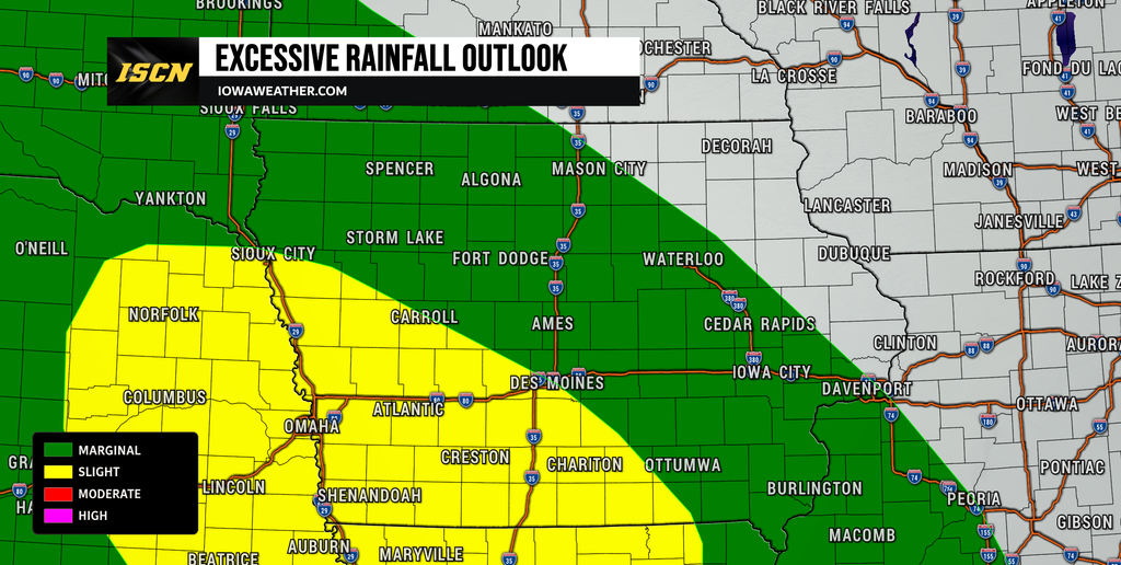
Sunday night may bring the first period when rainfall rates become heavy enough to cause localized flooding concerns. A strengthening low-level jet, which is a ribbon of fast-moving air a few thousand feet above the ground, will transport warm and moisture-rich air northward into Iowa. That flow will intersect a frontal boundary draped across the region, providing a focus for repeated showers and thunderstorms. Even thunderstorms without significant wind or hail could produce very heavy rain because of the unusually deep moisture available in the atmosphere. Southwest and western Iowa initially appear to have an enhanced chance of seeing heavier rainfall, although the axis could shift farther north or south depending on where the boundary sets up. Confidence is high that rain becomes widespread, but confidence is lower regarding the exact communities that receive the highest totals.
Travel could become more difficult Sunday night where heavier thunderstorms develop, especially along stretches of Interstate 80, Interstate 29, and other highways in western and central Iowa. Ponding water may develop on roads where rainfall rates become high, and visibility could fall quickly beneath heavier thunderstorms. Smaller streams and urban drainage systems will also need to be monitored if storms repeatedly cross the same locations. This does not mean widespread flooding is guaranteed Sunday night, but it will begin a period in which the ground could become increasingly saturated. Residents should pay closer attention to live weather radar and local weather updates as the placement of the heaviest rain becomes clearer. The cumulative rainfall over several days will ultimately be more important than any single round of storms.
Severe Weather Risk Develops Monday
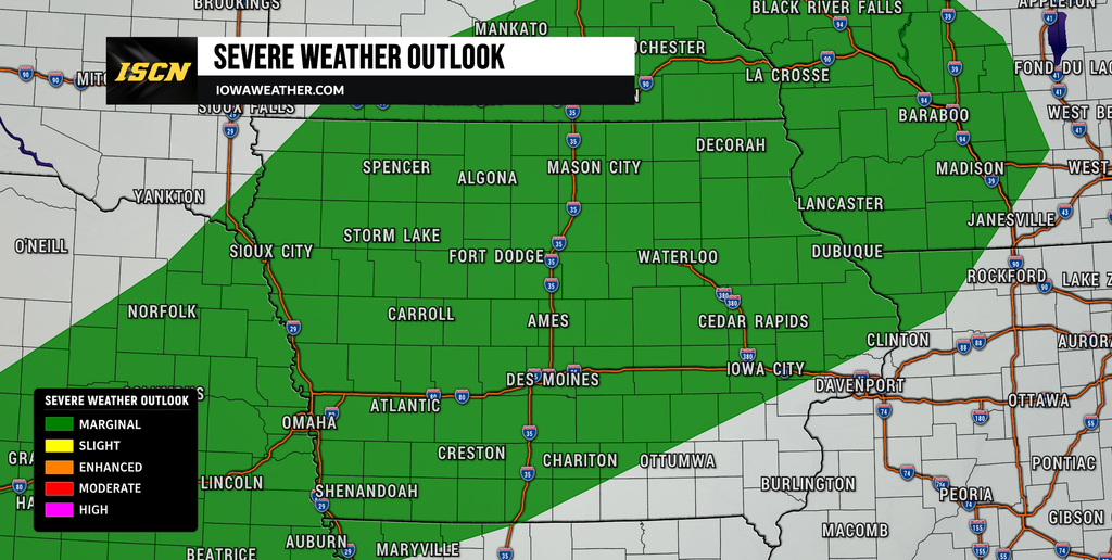
Monday brings the best opportunity for organized severe weather during this stretch, although several important uncertainties remain. A strengthening storm system moving through the northern Plains will pull warmer and more humid air northward into Iowa while winds strengthen at multiple levels of the atmosphere. This will create substantial wind shear, which is one of the ingredients needed for organized thunderstorms. The biggest question is how unstable the atmosphere becomes, particularly after widespread clouds and rain Sunday into Monday morning. If enough instability develops, storms forming later Monday could become strong to severe across portions of Iowa. Current guidance supports at least a marginal severe weather risk extending from the central Plains toward the Upper Midwest.
Damaging wind appears to be one of the more plausible hazards if storms organize into clusters or a line Monday evening. Strong winds a few thousand feet above the ground could be transported downward by thunderstorms, especially where storms become better organized. Large hail may also be possible with stronger storms, although the magnitude of that threat will depend on instability and storm mode. A tornado threat cannot be completely dismissed if storms become surface-based in the warm sector, but confidence in that scenario remains lower because clouds, rain, and warm air aloft may limit instability. This is therefore not a forecast that supports overstating a tornado threat several days in advance. The more important message is that Monday weather conditions favor an environment capable of supporting organized severe thunderstorms if sufficient instability develops.
Timing also remains somewhat uncertain because thunderstorms may occur in more than one round. Showers and storms could be ongoing Monday morning as the warm front lifts through the region, followed by a possible lull before another round develops along or ahead of an approaching cold front during the afternoon or evening. Western Iowa may encounter stronger storms earlier, with the threat potentially shifting into central and eventually eastern Iowa Monday evening or Monday night. Thunderstorms may become increasingly linear as they move east, which would favor damaging wind over more isolated hazards. Residents with Monday evening activities should plan to monitor the weather forecast throughout the day rather than relying on a forecast issued early in the weekend. Forecast confidence in thunderstorms is fairly high, while confidence in the coverage and intensity of severe weather remains moderate to low.
Flooding Concern Grows Monday Through Wednesday
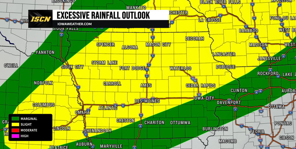
Heavy rain may ultimately become the more important weather story than severe thunderstorms as the week progresses. Iowa will remain positioned near a nearly stationary frontal boundary while deep moisture continues flowing north from the Gulf region. Atmospheric moisture values could approach 1.9 to 2 inches, which is exceptionally high for this time of year and supports very efficient rainfall production. Multiple disturbances moving along the boundary could then produce repeated rounds of thunderstorms Monday, Tuesday, and Wednesday. When storms travel over the same locations repeatedly, a process known as training, rainfall totals can increase rapidly even if individual storms are not severe. This setup creates a growing risk of flash flooding and eventually broader river or hydrologic concerns if the wet pattern persists.
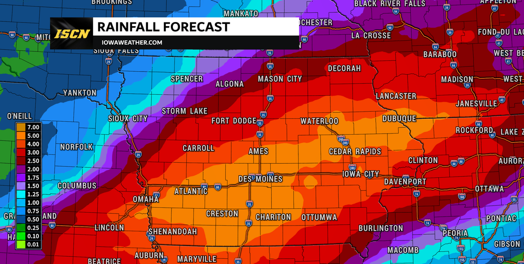
Southern Iowa is one area that bears particularly close watching Tuesday into Wednesday because several projections place the nearly stationary boundary from the central Plains through northern Missouri and southern Iowa. Current broader guidance suggests 2 to 3 inches of rain could fall within the favored corridor during portions of this period, while multi-day totals of 3 to 5 inches are possible near the boundary. Some locations could eventually receive even more if thunderstorms repeatedly track over the same area. Eastern Iowa also has a substantial chance of accumulating more than 2 inches by the end of the week, with localized totals above 4 inches possible. Those amounts are not guaranteed in any individual town because shifting the front by even 50 miles could significantly change the rainfall distribution. Confidence is nevertheless increasing that some part of Iowa or the nearby Missouri Valley will experience a meaningful heavy rain and flooding threat.
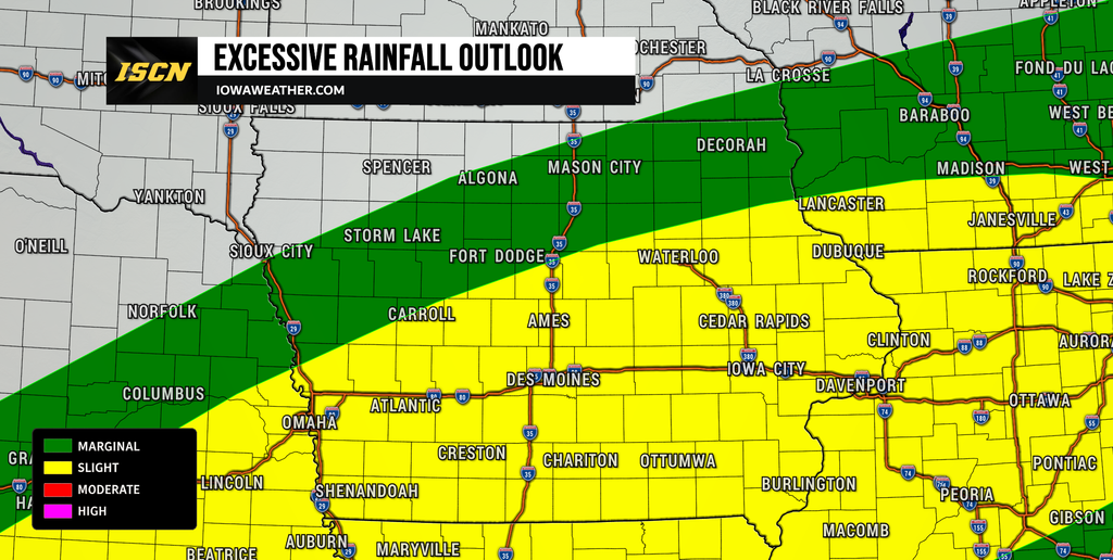
The flooding risk is expected to evolve rather than arrive everywhere at once. Initially, flash flooding would be most likely beneath thunderstorms producing very high rainfall rates or repeatedly moving over the same location. After several days of rain, saturated soils could allow runoff to increase more quickly, raising the risk along creeks, streams, low-lying roads, and eventually some rivers. Urban areas could also experience drainage problems where intense rain falls over a short period. Drivers should never attempt to cross a road covered by moving water, even if the depth is difficult to judge. Anyone living near a flood-prone creek or low-water crossing should monitor weather alerts closely through the middle of the week. The exact flood threat will become much clearer once forecasters can determine where the stationary front sets up.
Temperatures Swing Before Cooler Weather Returns
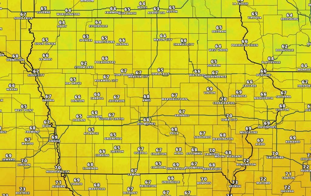
Temperatures will fluctuate considerably depending on which side of the frontal boundary a location sits on. Sunday will be cool across much of Iowa, with many communities staying in the 60s or lower 70s under clouds and rain. Temperatures may rebound sharply Monday as warmer air surges north, especially if the warm front advances far enough through central and southern Iowa. Parts of the region could briefly climb into the 80s, while areas that remain north of the front stay considerably cooler. Those temperature differences will help strengthen the front and contribute to the active thunderstorm pattern. After the main system passes, cooler air should become more established across the Upper Midwest.
The remainder of the week currently favors near- to below-average temperatures for much of northern Iowa and the surrounding region. Highs in the 60s and 70s may become common again once cooler air pushes south behind the front. Southern Iowa could remain somewhat warmer at times if the stalled boundary stays nearby, making temperature forecasts more uncertain from day to day. Cloud cover and repeated rainfall will also limit daytime heating in areas receiving the most persistent rain. Anyone searching the weather this week should expect frequent adjustments to both temperatures and rain chances because small changes in frontal position will have a large influence on local conditions. Overall, the pattern will feel much more like early fall than the warmer weather experienced ahead of the weekend cold front.
Looking Ahead
The main period to watch begins Sunday and continues through at least Wednesday as repeated rounds of rain and thunderstorms affect Iowa. Sunday will primarily feature widespread rain and pockets of heavy rainfall, while Monday introduces the best chance for organized severe weather. By Tuesday and Wednesday, attention increasingly shifts toward where the stationary front stalls and whether repeated thunderstorms create a more substantial flooding problem. Several inches of rain may accumulate in the wettest corridor, but the placement of that corridor remains one of the biggest forecast uncertainties. Cooler temperatures should become more common later in the week, although showers and thunderstorms may remain possible as long as the boundary and upper-level disturbances remain nearby. Forecast confidence is high that Iowa is entering an active and wet pattern, but confidence in exact rainfall totals and the location of the greatest flooding threat remains lower.
Residents should check the local weather forecast frequently over the next several days because thunderstorm timing, severe weather potential, and rainfall totals will continue to be refined. Sunday night through Wednesday is a period when keeping weather alerts enabled and checking weather radar before travel will be especially useful. Those with outdoor events, agricultural work, or travel plans should build flexibility into their schedules because repeated rain may lead to delays. Anyone in a location that commonly experiences flooding should pay particular attention if several rounds of heavy rain affect the same area. Additional changes to the severe weather outlook are also possible as Monday draws closer and the amount of available instability becomes clearer. Stay with IowaWeather.com for the latest Iowa weather updates, radar information, severe weather coverage, and changes to the rain and flooding forecast.