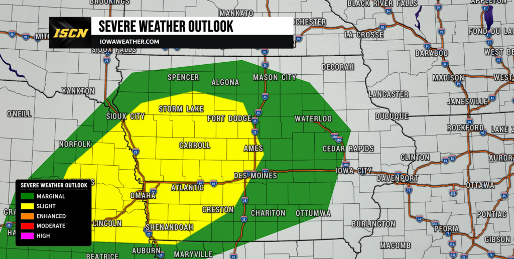
A more active weather pattern is taking shape across Iowa, with the biggest concern arriving Monday as conditions become favorable for severe thunderstorms across western and central Iowa. Large hail and damaging winds will be possible with the strongest storms, while enough low-level wind shear may also support a tornado threat. The greatest severe weather potential currently appears to develop late Monday afternoon into the evening, although exactly how widespread severe storms become will depend heavily on what happens earlier in the day.
Monday will not be a clear-sky-then-storms type of setup. Showers and thunderstorms are expected during the morning across portions of Iowa, and leftover clouds could limit how quickly the atmosphere becomes unstable during the afternoon. If enough clearing and warming occurs, however, the combination of increasing instability, strong wind shear and a nearby frontal boundary could support organized severe thunderstorms. Heavy rain is another significant concern, especially where thunderstorms repeatedly move across the same locations Monday night.
Severe Weather Threat Increases Across Iowa Monday
A Slight Risk for severe weather covers a large portion of western and central Iowa Monday, with a Marginal Risk extending farther north and east. The Slight Risk includes areas near Sioux City, Storm Lake, Carroll, Fort Dodge, Ames and portions of the Des Moines metro, while the exact risk boundaries may be adjusted as newer forecast data arrives. The environment could become supportive of organized thunderstorms as a warm front moves north and a stronger weather system approaches from the west. Wind speeds will increase considerably with height, producing the wind shear necessary for storms to organize and potentially rotate. The biggest question is whether the atmosphere can become sufficiently unstable after morning rain and cloud cover. Confidence is therefore fairly high that thunderstorms will occur Monday, but lower regarding exactly how numerous the severe storms will become.
The timing of the greatest severe weather risk currently favors late Monday afternoon through Monday evening. Northwestern Iowa could see a relatively narrow window for stronger storms during the afternoon and early evening, while the threat may extend farther into western and central Iowa as the system progresses. Some forecast guidance suggests storms could initially develop as individual cells before eventually organizing into clusters or a larger line of thunderstorms. That initial storm mode will be important because isolated storms would have a higher opportunity to produce large hail or develop rotation. Eventually, storms should become more widespread Monday night as the cold front advances into Iowa. The severe weather threat should gradually decrease overnight as instability weakens, although heavy rain and thunderstorms may continue.
Large Hail and Damaging Winds Are the Main Severe Weather Concerns
Large hail and damaging wind gusts appear to be the primary hazards with any severe thunderstorms that develop Monday. Forecast guidance shows roughly 40 to 50 knots or more of deep-layer wind shear in parts of the region, which is sufficient to support organized thunderstorms if adequate instability develops. Western Iowa has the greatest opportunity to become unstable during the afternoon as warmer and increasingly humid air moves northward. Temperatures could climb considerably in areas that receive enough sunshine, while locations stuck beneath clouds and morning rain may remain cooler. That temperature difference could ultimately help determine where the strongest storms develop. Residents across western and central Iowa should therefore pay particularly close attention to forecast updates Monday morning as the amount of clearing becomes apparent.
A few thunderstorms could become supercells if they remain isolated long enough during the initial stages of development. Supercells are rotating thunderstorms capable of producing hazards such as large hail, damaging winds and tornadoes, although not every supercell produces all three. As additional storms develop, interactions between them may encourage a transition toward clusters or a larger line. That evolution could gradually shift the primary hazard toward damaging winds and heavy rainfall Monday evening. There remains uncertainty about exactly how quickly this transition occurs, which is another reason the severe weather forecast may change as higher-resolution model guidance gets closer to the event. The overall environment supports a legitimate severe weather threat, but it is not yet clear how widespread severe storms will become.
Tornadoes Are Possible, but the Threat Is Conditional
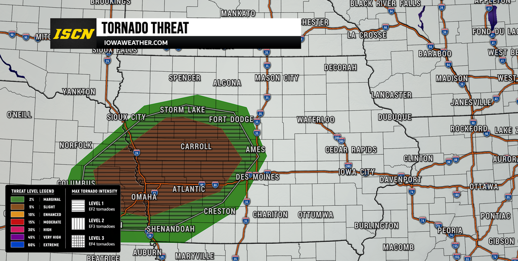
There is also a tornado risk Monday, particularly if isolated thunderstorms can develop within the increasingly favorable wind environment. Winds are expected to strengthen and change direction with height, creating curved storm-relative wind profiles that can support rotating thunderstorms. This appears especially relevant near the warm front, where low-level wind shear could become locally enhanced. A tornado or two cannot be ruled out if storms become rooted near the surface and interact with that boundary. However, the tornado threat is more conditional than the overall hail and damaging wind risk because instability remains a significant question. Morning thunderstorms, widespread clouds and lingering cooler air could substantially reduce the tornado potential if the atmosphere fails to recover.
This is an important part of Monday’s forecast because the ingredients for rotating storms may be present even though one critical ingredient—surface-based instability—is less certain. If skies brighten and temperatures climb more aggressively Monday afternoon, the severe weather threat could increase fairly quickly. If clouds remain widespread and temperatures struggle, thunderstorms could still produce heavy rainfall while the severe threat remains more limited. Northwestern and western Iowa may be among the first places where forecasters can assess whether meaningful destabilization is occurring. Conditions farther east will then depend partly on how storms evolve as they move into central Iowa. The tornado potential should become much clearer with Monday morning observations and short-term forecast guidance.
Morning Rain Could Determine How Strong Monday’s Storms Become
One of the biggest factors in the Iowa weather forecast Monday will be what happens before the main severe weather window begins. A strengthening southerly flow above the surface should transport warm, moisture-rich air into the region overnight and Monday morning, helping showers and thunderstorms develop. This early activity is not expected to represent the primary severe weather threat, but it could have a major influence on what happens later. Extensive rain and clouds would keep temperatures lower and make it harder for instability to build. A quicker departure of the morning storms followed by several hours of warming would create a more favorable environment for severe thunderstorms. This makes Monday an unusually important day to monitor changing conditions rather than relying solely on a forecast issued the night before.
The difference could be substantial across relatively short distances. Parts of eastern Nebraska and western Iowa may warm considerably if they break into the warm sector, while locations farther north could remain underneath clouds and cooler air. Northwestern Iowa is particularly sensitive to how far north the warm front advances during the afternoon. Farther east, including eastern Iowa, severe weather probabilities are currently lower, although thunderstorms are expected to spread east Monday night. Areas north of Interstate 80 in eastern Iowa currently have at least a lower-end risk for damaging winds as storms arrive overnight. The evolution of the warm front and afternoon instability will ultimately determine how far east the more substantial severe weather threat can develop.
Heavy Rain and Flash Flooding Could Become a Major Concern
Severe weather will get much of the attention Monday, but heavy rain and flash flooding may become an equally important hazard Monday into Tuesday. Atmospheric moisture is expected to increase dramatically, with precipitable water values approaching 1.8 to 2 inches in portions of Iowa. In simple terms, that means the atmosphere will contain an unusually large amount of moisture for mid-September and thunderstorms will be capable of producing very heavy rainfall. Some atmospheric moisture measurements are forecast near the extreme upper end of what is typically observed in Iowa at this time of year. The concern increases further because storms may repeatedly travel over the same locations rather than quickly clearing the state. This process, known as training, can produce significant rainfall totals in a relatively narrow corridor.
Some forecast guidance suggests 3 to 5 inches of rain could fall within 24 hours where the most persistent thunderstorms develop, particularly if a heavy-rain corridor becomes established Monday night into Tuesday. Those numbers should not be interpreted as a statewide rainfall forecast because the exact placement of the frontal boundary remains uncertain. A shift of even 50 to 100 miles could substantially change which communities receive the heaviest rainfall. Urban areas would be particularly vulnerable if several thunderstorms repeatedly produce torrential rain over the same location. Creeks, streams and low-lying roads could also respond quickly, while additional rainfall later in the week could eventually cause larger rivers to rise. Confidence is high that portions of Iowa will receive substantial rain, but confidence remains lower regarding exactly where the highest totals occur.
Showers and Cooler Weather Across Iowa Sunday
Before Monday’s severe weather threat arrives, rain chances increase across Iowa Sunday, with scattered to more widespread showers and thunderstorms moving through portions of the state. Atmospheric moisture is already increasing, so some showers may briefly produce moderate to heavy rain. Severe weather is not expected to be a significant concern Sunday because instability is limited across much of the region. Temperatures will also remain relatively cool, with many areas struggling to get much beyond the upper 60s and lower 70s. Rain coverage should gradually decrease later Sunday, allowing for at least a temporary break Sunday evening and early Sunday night. Conditions then become more active again toward Monday morning as stronger southerly winds begin transporting moisture northward.
For anyone wondering will it rain today, the answer is yes for many areas, although rain will not necessarily continue throughout the entire day. The most widespread activity should move progressively through the region, which helps reduce the risk of widespread flooding from Sunday’s rain alone. Southwestern Iowa has a somewhat greater opportunity for locally heavy rainfall, and isolated ponding of water or minor flooding cannot be ruled out. Sunday rainfall could also leave the ground wetter ahead of Monday’s potentially much heavier thunderstorms. That becomes increasingly important if the same areas receive multiple rounds of rain through the middle of the week. Sunday is therefore best viewed as the beginning of a much wetter weather pattern rather than the main event.
Flooding Concerns May Continue Through the Middle of the Week
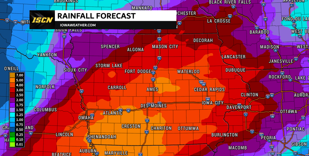
The active pattern does not end once Monday’s storms move through. A frontal boundary is expected to slow or stall near the region, providing a focus for additional rounds of rain and thunderstorms Tuesday through Wednesday and potentially later in the week. Individual periods of rain may be separated by several hours of quieter weather, but repeated thunderstorms could gradually saturate the ground. Eastern Iowa has a strong signal for at least 2 inches of total rainfall through the week, while localized totals exceeding 5 inches are possible depending on where repeated storm tracks become established. Northern and central Iowa could also experience significant rainfall, particularly near the persistent frontal zone. The exact corridor of heaviest rain remains uncertain and will probably shift as forecast models better resolve the boundary.
Flooding concerns may evolve from localized flash flooding into a broader river flooding issue if repeated heavy rain occurs. Smaller creeks and streams would respond first, especially where several inches of rain fall within a short period. Larger rivers could begin rising during the second half of the week as runoff from multiple rounds of rainfall moves downstream. This does not mean widespread river flooding is guaranteed, but the pattern warrants close monitoring because additional storms remain possible after Monday. The location of the stalled boundary will be critical in determining which parts of Iowa receive repeated rainfall. Residents living near flood-prone areas should keep up with the latest weather forecast throughout the week rather than focusing exclusively on Monday’s severe weather.
Looking Ahead
Monday is the day that deserves the most attention in the immediate forecast, with severe weather possible across western and central Iowa during the late afternoon and evening. Large hail and damaging winds are the primary threats, while a tornado or two will also be possible if the atmosphere becomes sufficiently unstable. Morning rain and cloud cover create meaningful uncertainty, and the amount of clearing Monday afternoon could make the difference between a relatively limited severe event and a more active period of organized thunderstorms. Heavy rainfall may become an increasingly important hazard Monday night, especially where storms repeatedly move over the same communities. Additional thunderstorms Tuesday and Wednesday could increase both flash flooding and river flooding concerns as the week progresses. The active weather pattern may continue into the latter half of the week, although confidence in the specific timing and location of later storm systems is lower.
The most important thing for Iowans is to check the forecast again Monday morning. By then, we should have a much better idea of where the warm front is located, how widespread morning thunderstorms are, and whether western Iowa is beginning to destabilize ahead of the afternoon severe weather window. Keep up with IowaWeather.com for the latest Iowa weather forecast, severe weather updates and changes to Monday’s storm threat.