Iowa residents can expect several more days of unusually warm October weather before a changing weather pattern brings stronger winds, increasing rain chances, and cooler temperatures this weekend. Afternoon highs will climb well into the 70s across much of the state through Friday, with a few locations in western and northwestern Iowa potentially reaching 80 degrees. These temperatures are running roughly 10 to 20 degrees above what Iowa typically experiences during the second half of October.
The warm and relatively quiet weather will not last indefinitely. A developing storm system across the western United States will gradually shift toward the northern Plains, strengthening southerly winds across Iowa by Friday. The combination of gusty winds and dry vegetation could also increase fire weather concerns, particularly across northwest Iowa, where agricultural fields and grasses have become increasingly dry.
Rain chances will return to parts of Iowa this weekend as a cold front slowly moves into the state. Northwest Iowa has the best opportunity for measurable rainfall beginning Saturday, while central, southern, and eastern Iowa may have to wait until Sunday or Monday. Behind the front, temperatures will trend closer to seasonal averages, although the exact timing and strength of the cooldown remain somewhat uncertain.
Iowa Weather Today: Sunshine and Temperatures Well Above Average
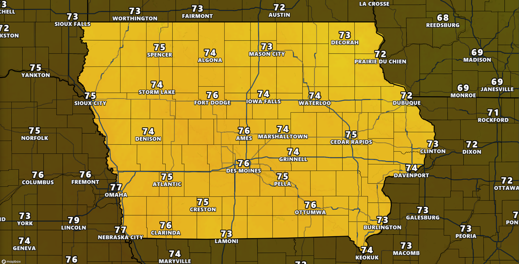
Wednesday will bring another pleasant autumn afternoon across Iowa, with plenty of sunshine and temperatures that feel more like September than late October. Most communities across central, southern, and western Iowa will reach the mid to upper 70s, while eastern and northeastern Iowa can expect highs ranging from the upper 60s to middle 70s. For perspective, typical afternoon temperatures during this time of year range from the upper 50s to lower 60s, making today’s readings nearly 15 degrees above average in many locations. A large area of high pressure, combined with an unusually warm air mass over the central United States, is helping maintain these comfortable conditions. Most Iowa residents can expect favorable weather for outdoor activities, fieldwork, and afternoon travel.
A weak disturbance moving across the southern part of the state has produced a few light showers and sprinkles early Wednesday morning. Portions of southwest and southern Iowa have the best chance of seeing this activity, although rainfall amounts should remain minimal because the lower atmosphere is relatively dry. Some precipitation may evaporate before reaching the ground, especially as the disturbance moves toward southeast Iowa. Clouds associated with this system will gradually decrease as it moves east, allowing sunshine to become more widespread through the day. Outside of these isolated morning showers, measurable rainfall is not expected across most of Iowa today.
Thursday and Friday: October Warmth Continues Across Iowa
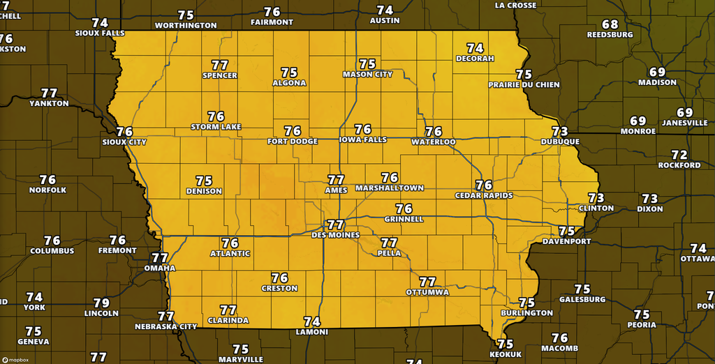
The Iowa weather forecast for Thursday and Friday continues to feature unusually warm temperatures, with little indication of a significant cooldown before the weekend. Highs will generally reach the middle and upper 70s across much of the state, with a few western and northwestern Iowa communities potentially touching 80 degrees. Eastern Iowa will also remain warm, with afternoon temperatures largely in the 70s. The warmth is being supported by a strong ridge of high pressure in the upper atmosphere, which helps maintain an air mass that is considerably warmer than normal for late October. Although these temperatures are impressive for the season, widespread record highs are not currently anticipated.
Thursday should remain dry across nearly all of Iowa, although some additional cloud cover may develop across the northwest as moisture increases over the Plains. Friday will bring a more noticeable change as the pressure difference between weather systems strengthens, causing southerly winds to increase. These winds will help maintain warm temperatures but will also make conditions feel considerably breezier than earlier in the week. A few isolated light showers cannot be ruled out near the far northwestern edge of Iowa early Friday, but the more meaningful rain opportunities are expected later in the weekend. Confidence remains high that above-average temperatures will continue through Friday, even as the weather pattern begins to change.
Strong Winds Friday Could Increase Fire Weather Concerns
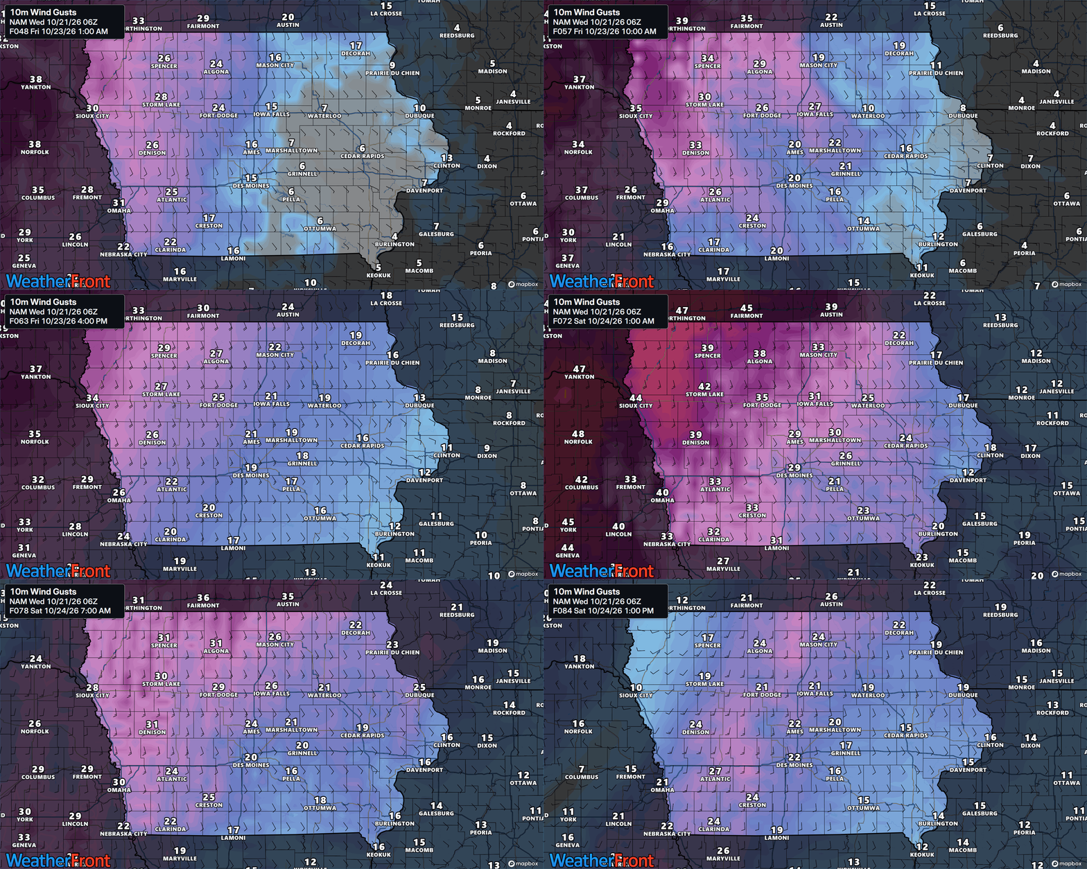
Friday is shaping up to be the windiest day of the week across much of Iowa, particularly in western and northern portions of the state. Southerly wind gusts of 30 to 40 mph are possible across the broader region, with northwest Iowa among the areas most likely to experience the stronger winds. The increasing winds will develop as a large storm system approaches the northern Plains and the pressure difference between weather systems becomes stronger. Breezy conditions may begin Thursday afternoon across far western Iowa before spreading farther east Thursday night and Friday. Winds are also expected to remain noticeable Saturday, although the strongest gusts and their exact locations will depend on the evolution of the approaching storm system.
The stronger winds will bring an increased concern for grass and field fires, especially across northwest Iowa, where dry agricultural vegetation could allow flames to spread quickly. Relative humidity is not expected to become exceptionally low in all areas, which should help limit the overall fire threat. However, strong winds can still create dangerous conditions if a fire starts, particularly where grasses, crop residue, and other vegetation are dry. Farmers completing harvest operations should take additional precautions around equipment that could produce sparks or excessive heat. Outdoor burning should be avoided when winds are strong, and residents should pay attention to any fire weather alerts issued as Friday approaches. Confidence is high that windy conditions will develop, while the extent of the fire weather threat will depend on local humidity and vegetation conditions.
Weekend Rain Chances Return as a Cold Front Approaches
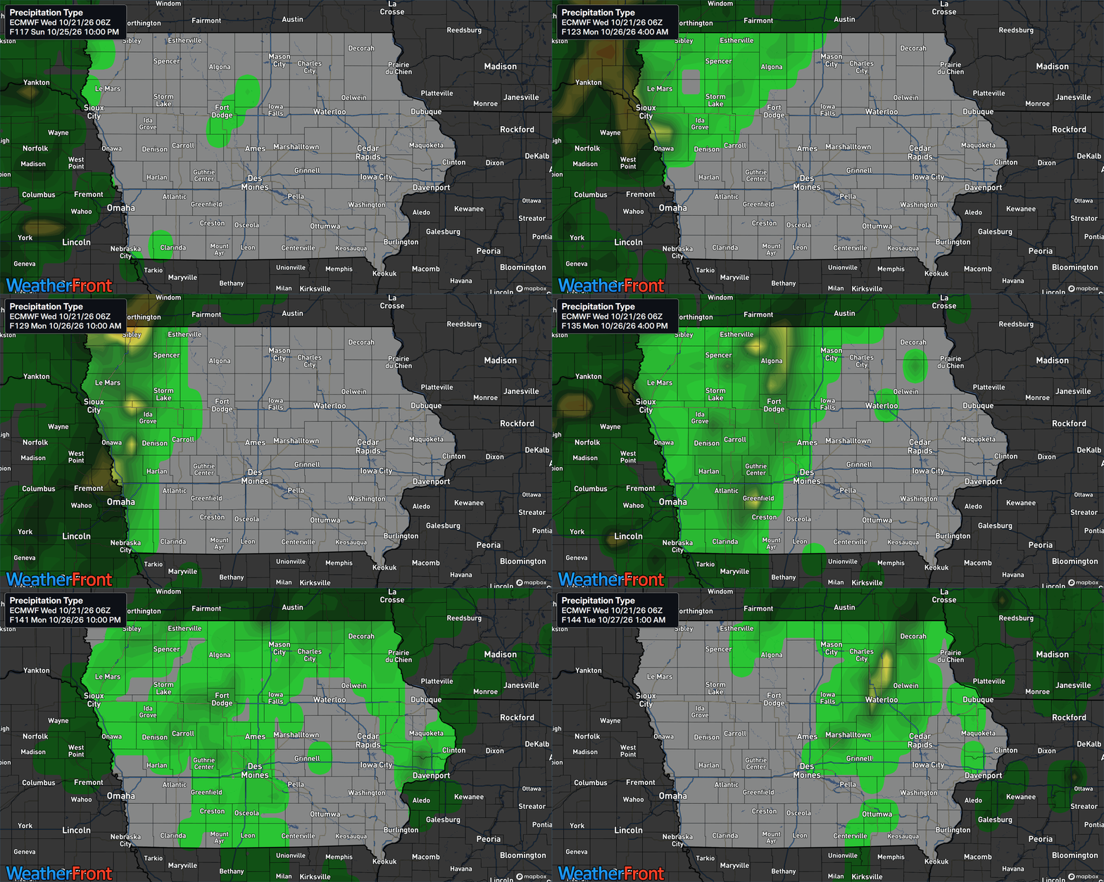
After several days of mostly dry weather, Iowa’s next meaningful opportunity for rainfall will arrive this weekend as a cold front moves southeastward from the northern Plains. The front will be associated with an area of low pressure tracking across southern Canada, while increasing moisture and rising air along the boundary help generate scattered showers. Rain chances should begin increasing across northwest Iowa early Saturday, with the greatest likelihood of precipitation extending into Saturday afternoon and evening. Communities in northwest Iowa have approximately a 40 to 60 percent chance of rain during the weekend, depending on location and timing. Farther southeast into central Iowa, rain probabilities are initially much lower, generally around 10 to 20 percent Saturday.
The best chance of measurable rainfall will initially favor northwest Iowa, including areas near Sioux City, Spencer, and surrounding communities. Locations such as Des Moines, Ames, and Fort Dodge may see a few showers as the front progresses, but widespread rain is not guaranteed. Southern and eastern Iowa, including communities near Ottumwa, Iowa City, and the Quad Cities, should remain mostly dry Saturday, with better opportunities for showers developing Sunday into Monday. The timing of the front will be important because its movement may slow as it pushes farther into Iowa. This could produce noticeable differences in rainfall between communities separated by relatively short distances, making the forecast less certain farther into the weekend.
How Much Rain Could Iowa Receive This Weekend?
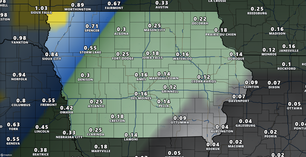
Rainfall amounts from the approaching system are generally expected to remain light, although some communities could receive a more beneficial soaking. Across northwest Iowa and nearby portions of southeast South Dakota and northeast Nebraska, there is approximately a 60 percent probability of receiving at least one-quarter inch of rain during the weekend system. However, many locations may only collect a few hundredths to around one-tenth of an inch, particularly where showers remain scattered. Farther east, portions of northeast Iowa could receive rainfall amounts approaching one-half inch as the front progresses through Sunday and Monday. The exact rainfall distribution will depend on where the front slows and whether additional disturbances develop along it.
At this time, widespread flooding does not appear to be a significant concern based on the expected rainfall amounts. The greater question is how much moisture will become available along the approaching front and whether showers become organized enough to produce more consistent rainfall. Northwest Iowa currently has the strongest signal for precipitation earlier in the weekend, while the eastern half of the state may see better opportunities later. Some forecast guidance suggests that additional rain could develop Monday as another disturbance moves into the region. Confidence is moderate that at least portions of Iowa will receive rainfall, but confidence is lower regarding specific amounts at individual locations.
Weekend Temperatures: Warm Saturday Before Cooler Air Arrives
Saturday’s temperature forecast will depend heavily on the location and timing of the approaching cold front. Areas ahead of the front, particularly across southern and eastern Iowa, could remain quite warm with afternoon highs reaching the 70s. Northwest Iowa may begin cooling earlier as winds shift and cooler air spreads southeast behind the boundary. The temperature difference across the state could become fairly noticeable, especially if the front advances through western and northern Iowa during the daytime hours. Residents planning outdoor activities Saturday should prepare for breezy conditions and the possibility of scattered showers, particularly in northwest Iowa.
By Sunday, cooler air is expected to become more established across much of the state, with highs generally settling into the upper 50s and 60s. The cooler weather will bring temperatures closer to what Iowa typically experiences during late October, following several days of exceptional warmth. Monday may be cooler still in some northern and eastern communities, with highs in the 50s as the front continues moving through the region. Overnight temperatures should also decrease, with many locations returning to the 40s and some northern areas potentially dropping into the 30s early next week. The exact strength of the cooldown remains uncertain because forecast guidance differs on how quickly the colder air will move south and east.
Looking Ahead: A More Active Weather Pattern Possible Into Early November
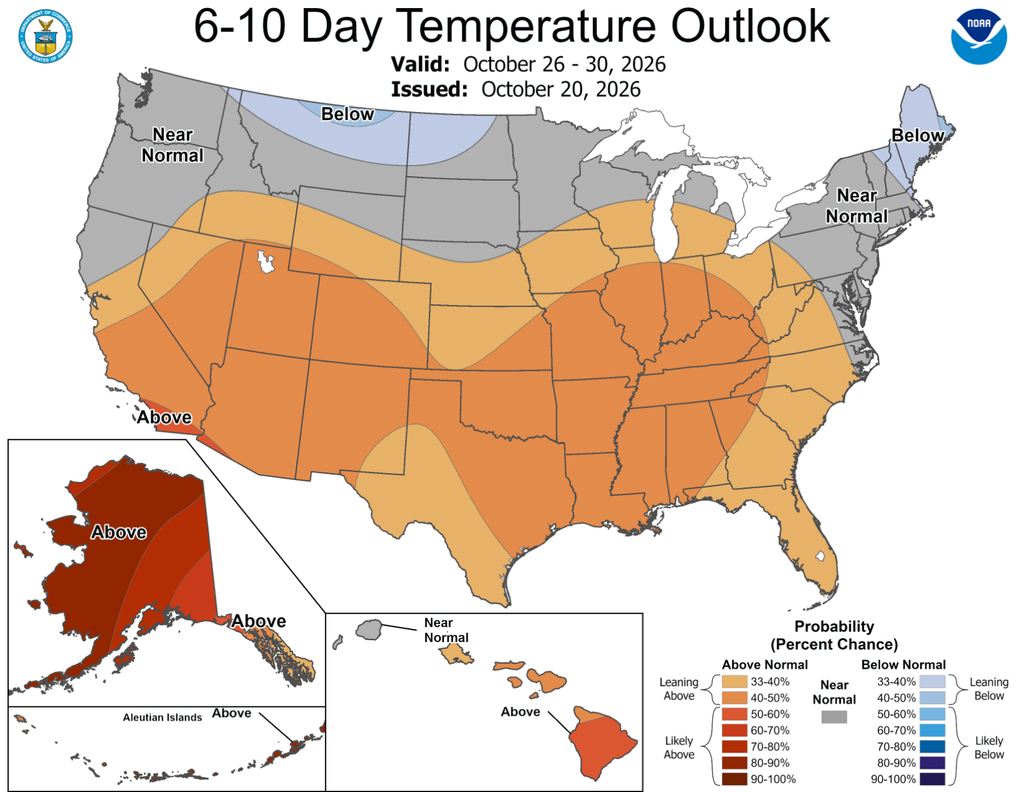
The longer-range Iowa weather forecast suggests that the unusually warm and mostly dry pattern of this week could give way to a more changeable period during the final days of October. From October 26 through October 30, the overall atmospheric pattern is expected to feature a developing trough over the western United States and warmer air remaining established across parts of the central and eastern country. Iowa will be near the transition between these competing weather patterns, making temperature trends less certain than they are for the next several days. Northern Iowa may be more exposed to cooler air moving south from Canada, while southern Iowa could remain closer to the warmer air mass. As a result, temperatures may fluctuate more frequently rather than following a steady warming or cooling trend.
The precipitation outlook also suggests that opportunities for rainfall could increase across portions of the central United States as the western storm pattern becomes more active. For October 28 through November 3, above-normal precipitation is favored across much of the country, including a large portion of the central United States, while the signal is weaker near the northern Plains and Upper Midwest. This does not necessarily mean Iowa will experience rain every day or that significant rainfall totals are guaranteed. Instead, it indicates that the broader weather pattern may become more favorable for precipitation during the transition into November. Confidence in the overall weather pattern is above average for the October 26–30 period, but decreases for the October 28–November 3 outlook as differences between forecast models become more important.
For Iowa residents, the most important weather developments to monitor over the next several days will be Friday’s strong winds, the timing of weekend rain, and the arrival of cooler temperatures Sunday into Monday. Those with outdoor plans Saturday should pay particular attention to the forecast in northwest Iowa, where showers are more likely to arrive earlier than elsewhere in the state. Farmers and others working outdoors should also monitor the fire weather potential Friday, especially where vegetation remains dry. Looking farther ahead, the changing pattern may bring additional precipitation opportunities, although it is too early to determine exact timing or rainfall amounts. Forecast updates over the coming days should provide a clearer picture of how these systems will affect Iowa heading into November.
Stay connected with IowaWeather.com for the latest Iowa weather forecast, changing rain chances, wind updates, and weather conditions across the state.