Iowa Weather Forecast: Mild November Weekend Ahead, With Dry Conditions Continuing Into Next Week
November is bringing a welcome stretch of quiet weather to Iowa, with temperatures running above seasonal averages and little precipitation expected over the next several days. After a chilly start Saturday morning, November 7, afternoon temperatures will climb into the 50s across much of the state, with some locations approaching 60 degrees. The warming trend will continue into early next week, giving Iowans several opportunities to enjoy outdoor activities without worrying about rain or snow.
The biggest weather concern Saturday morning is patchy fog, particularly across river valleys and portions of northwest Iowa. Some locations could experience reduced visibility during the morning commute, and a few elevated road surfaces may become slick where temperatures are near freezing. Conditions should improve through late morning as fog dissipates, although lingering clouds could keep parts of northwest Iowa cooler than the rest of the state.
Looking farther ahead, temperatures could climb into the 60s across much of Iowa by Monday, with some of the warmest readings near the Missouri border. The dry pattern should continue through at least the first half of next week, although a passing cold front may introduce a small chance of precipitation around Wednesday or Thursday. Longer-range forecasts also favor above-normal temperatures into mid-November, suggesting this relatively mild weather pattern may have some staying power.
Sunday Weather: Weak Cold Front Brings Little Change
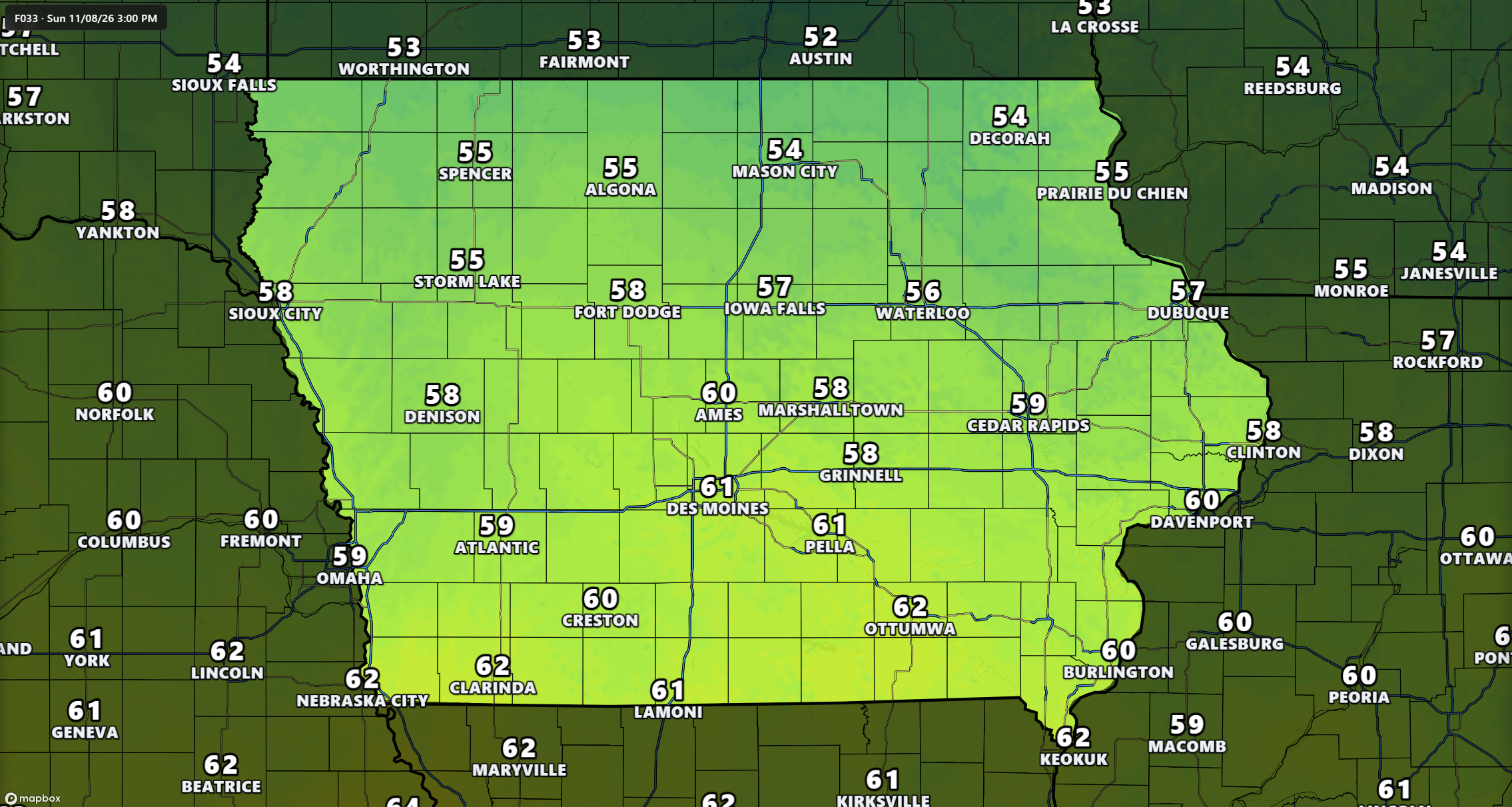
A weak cold front will move across Iowa on Sunday, but it will not bring the significant drop in temperatures often associated with November frontal passages. Instead, temperatures should remain mild, with highs generally reaching the upper 50s and lower 60s across much of the state. Some southern and southwestern communities could climb into the middle 60s, while northern areas may remain slightly cooler. The front will shift winds toward the west or northwest for a time, but the air behind it will not be substantially colder. As a result, Sunday could actually be warmer than Saturday in several locations.
Clouds may briefly increase as the front passes, although moisture levels remain too limited to support widespread rainfall. High pressure and a favorable upper-level weather pattern will continue to keep most of Iowa dry throughout the day. The primary uncertainty involves how much cloud cover develops and how quickly it clears, which could make a difference of several degrees in afternoon temperatures. Communities experiencing longer periods of sunshine will have the best opportunity to reach the lower or middle 60s. For anyone planning outdoor work, travel, or recreational activities, Sunday looks like another relatively pleasant November day.
Monday Could Bring Some of the Warmest Temperatures of the Week
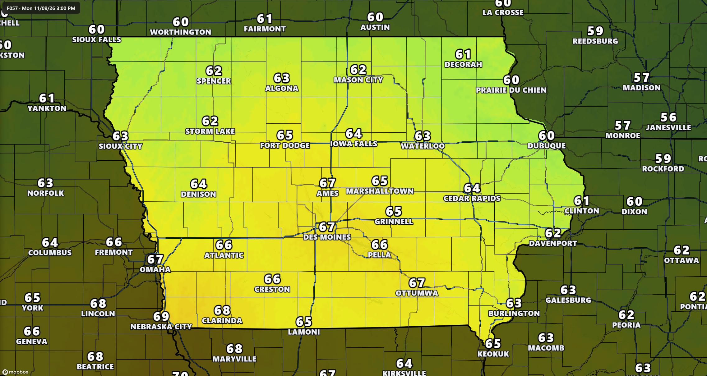
Monday, November 9, is shaping up to be one of the warmest days of the upcoming week, particularly across western, central, and southern Iowa. Afternoon temperatures should reach the lower to middle 60s across much of the state, with upper 60s possible in some western and southwestern communities. Locations near the Iowa-Missouri border could approach 70 degrees if sunshine and favorable winds develop as expected. Northern and northeastern Iowa will likely be somewhat cooler, although temperatures should still be relatively mild for early November. These readings would be above the typical daytime highs for this time of year, which are generally in the upper 40s to lower 50s across Iowa.
The warmer conditions will be supported by a broad area of relatively warm air in the atmosphere and periods of westerly or southwesterly winds. These winds help transport milder air into the region, while dry conditions allow afternoon temperatures to rise efficiently. A weak cold front moving through portions of the northern Plains may influence temperatures in western Iowa, but significant cooling is not expected immediately. The warmest readings will depend on the timing of that boundary, cloud cover, and the amount of afternoon sunshine. Confidence is relatively high that Monday will be mild, although the exact locations reaching the upper 60s or near 70 degrees remain less certain.
Rain Chances Remain Low Through the First Half of Next Week
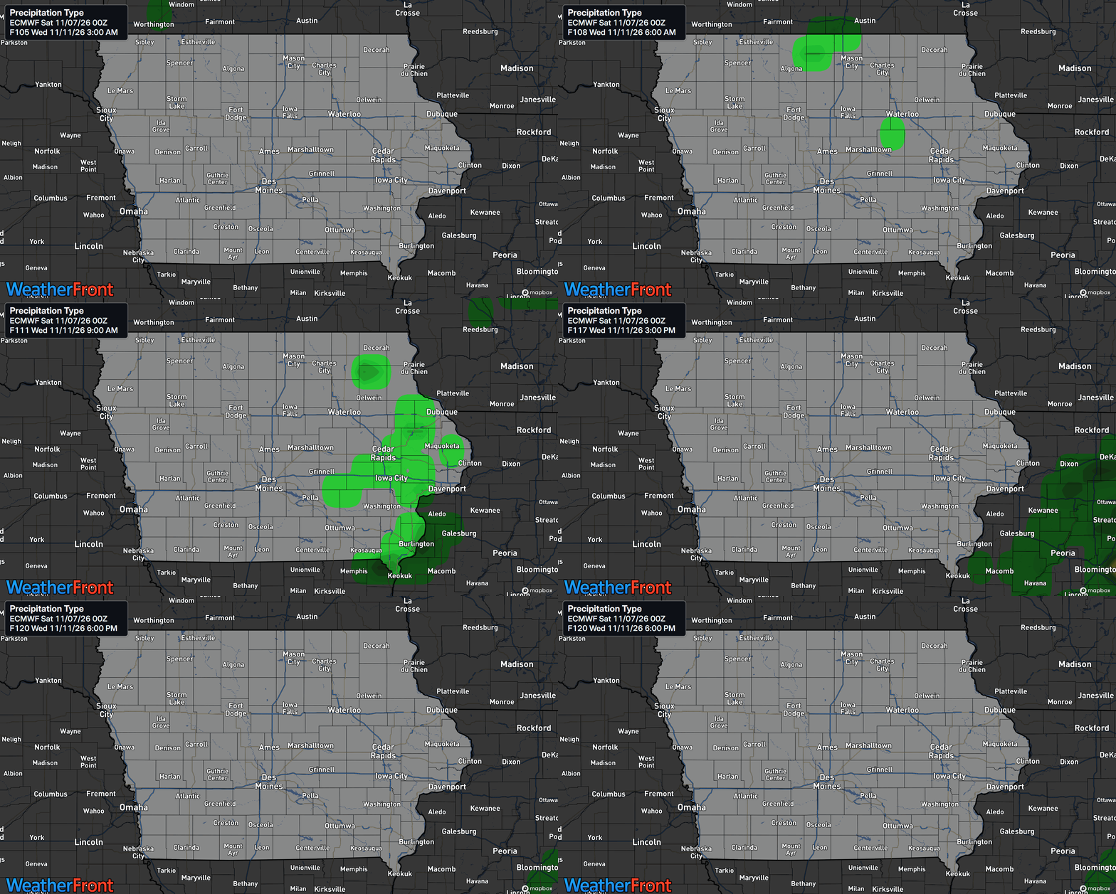
Anyone wondering when it will rain again in Iowa may have to wait several more days, as the current weather pattern strongly favors dry conditions. High pressure will remain influential across the Midwest, while the atmosphere lacks the moisture needed to produce widespread showers or thunderstorms. Several weak weather disturbances may pass through the region, but most should produce little more than occasional cloud cover. Rain chances remain very low from Saturday through Tuesday across nearly the entire state. Confidence in the dry forecast is high during this period, making it a favorable stretch for outdoor projects and travel.
A somewhat more uncertain forecast develops around Wednesday afternoon through Thursday, when another cold front may move southeast across the region. This system could bring a small chance of precipitation, particularly across northern and northeastern Iowa, although some forecast guidance keeps conditions completely dry. The uncertainty comes from differences in how the approaching disturbance interacts with the limited moisture available over the Midwest. Even if precipitation develops, the current information does not support a widespread heavy rain event. For now, the most likely outcome remains predominantly dry weather, with any midweek precipitation chances requiring additional monitoring.
Cooler Temperatures Could Return Late Next Week
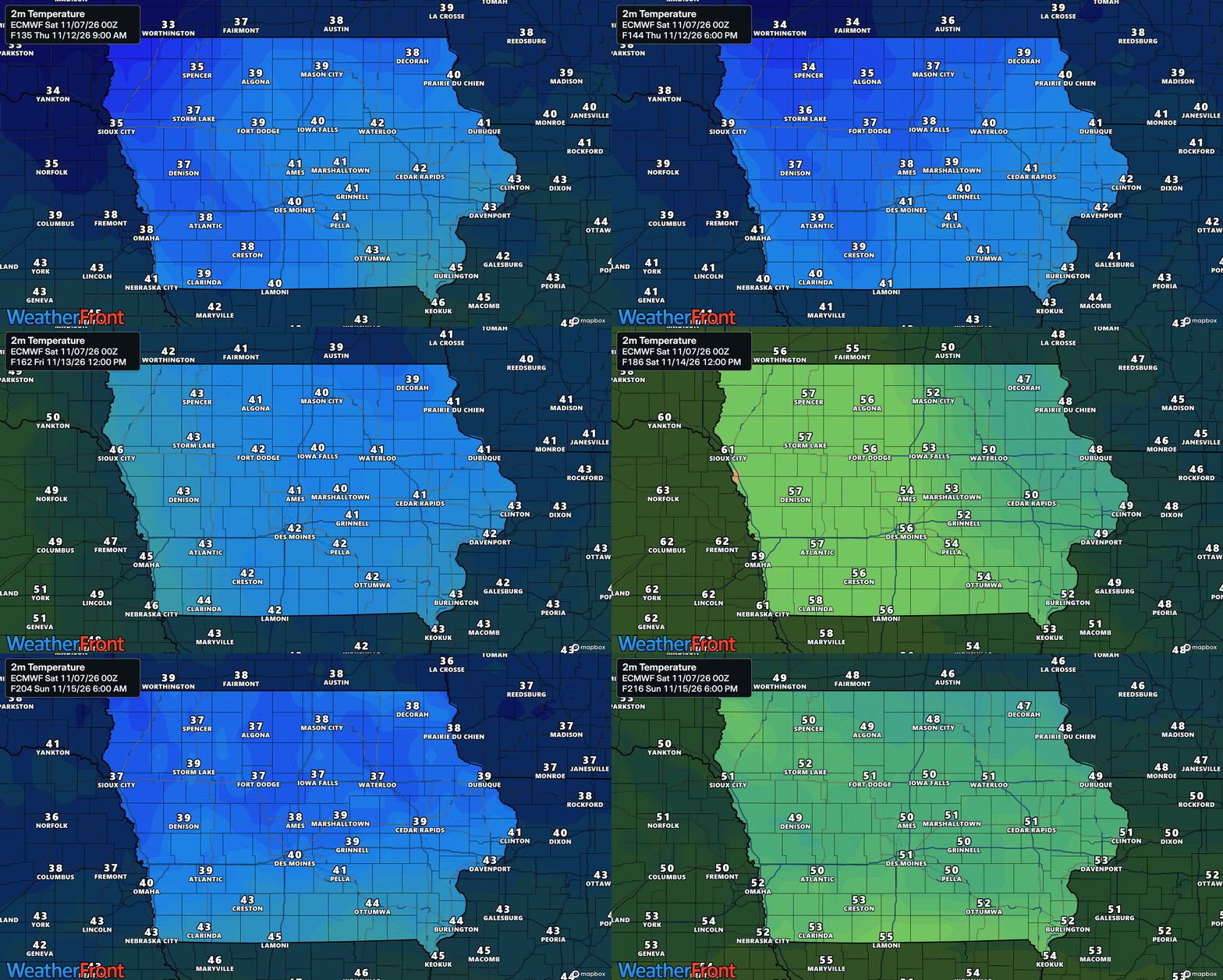
While the first half of next week will feature above-average temperatures, a change in the weather pattern could bring cooler air into Iowa by Wednesday through Friday. A cold front moving southeast from Canada will help shift winds and allow cooler air to spread into portions of the Midwest. Northern and northeastern Iowa appear most likely to experience the greatest cooling, with afternoon highs potentially falling into the 40s by Thursday and Friday. Central and western Iowa may remain somewhat milder, with temperatures generally in the 50s depending on the strength and position of the incoming cooler air. The cooling trend will be noticeable compared with Monday’s warmth, although it does not currently signal a major winter weather outbreak.
Overnight temperatures will also respond to the changing pattern, with lows generally ranging from the 30s to lower 40s during the milder portion of the week. Some northern and northeastern communities could return to the middle or upper 20s later in the week as cooler air settles into the region. The timing and extent of the temperature drop remain somewhat uncertain because the approaching cold front and upper-level weather pattern could evolve over the next several days. Forecast confidence is higher in a late-week cooling trend across eastern Iowa than in the exact temperature readings statewide. Residents should expect more typical November conditions toward the end of the week, especially in northern and eastern communities.
Mid-November Outlook Favors Above-Normal Temperatures
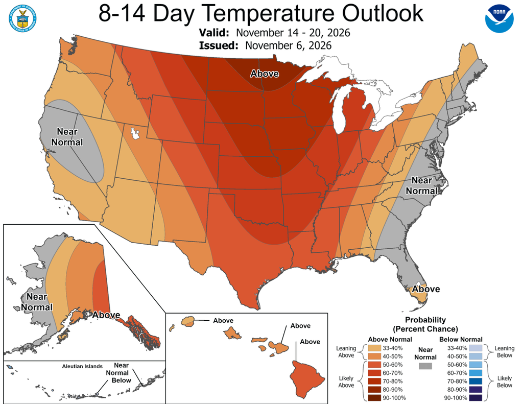
Despite the potential for cooler weather late next week, the broader weather pattern continues to favor above-normal temperatures across Iowa during the middle of November. The November 12–16 outlook indicates increased chances of warmer-than-average conditions across much of the central United States, including Iowa and neighboring states. A large area of high pressure in the upper atmosphere, often called a ridge, is expected to develop over central North America and help support the milder pattern. This setup generally favors warmer conditions by limiting the southward movement of the coldest Canadian air into the central Plains. Forecast confidence in the overall pattern is above average, with good agreement among the major global forecast models.
The precipitation outlook for November 12–16 leans toward below-normal rainfall across much of the central United States, including Iowa. This is consistent with the generally dry weather expected during the upcoming week, although it does not completely rule out isolated precipitation events. Looking even farther ahead, the November 14–20 outlook continues to favor above-normal temperatures across much of the country. Precipitation chances may begin increasing across portions of the central United States during that later period as the weather pattern gradually becomes more active. These longer-range outlooks describe the likelihood of temperatures and precipitation being above or below average rather than providing exact daily forecasts, so individual weather systems will become clearer as those dates approach.
Stay connected with IowaWeather.com for the latest Iowa weather forecast, updated temperature trends, radar information, and any changes to rain chances as the week progresses. We’ll continue monitoring the midweek cold front and the longer-range weather pattern to keep you informed about what comes next.