Iowa residents have one more opportunity to enjoy unusually mild November weather before a noticeable change arrives during the middle of the week. Temperatures will climb into the 60s across much of the state Tuesday, November 10, with plenty of dry weather and relatively light winds. That will put afternoon temperatures roughly 10 degrees above average for this time of year in many communities. However, a fast-moving weather system will bring gusty northwest winds Wednesday, followed by much colder temperatures Thursday and Friday. The change will be especially noticeable during the morning hours as temperatures fall well below freezing in many areas.
The good news is that widespread rain, snow, and significant winter weather are not expected with this system. A few showers could develop across eastern and northeastern Iowa Wednesday, but most locations will receive little or no precipitation. The bigger weather story will be the return of colder Canadian air, with afternoon temperatures struggling to climb out of the 40s late in the week. Morning lows will drop into the 20s in many locations, making this one of the colder stretches of the fall season so far.
The cooler weather should not last particularly long. Temperatures are expected to gradually recover over the weekend, with another period of above-average warmth becoming increasingly likely next week. Longer-range weather forecasts also suggest Iowa could see better opportunities for precipitation during the second half of November.
Iowa Weather Today: Sunshine and Highs in the 60s Tuesday
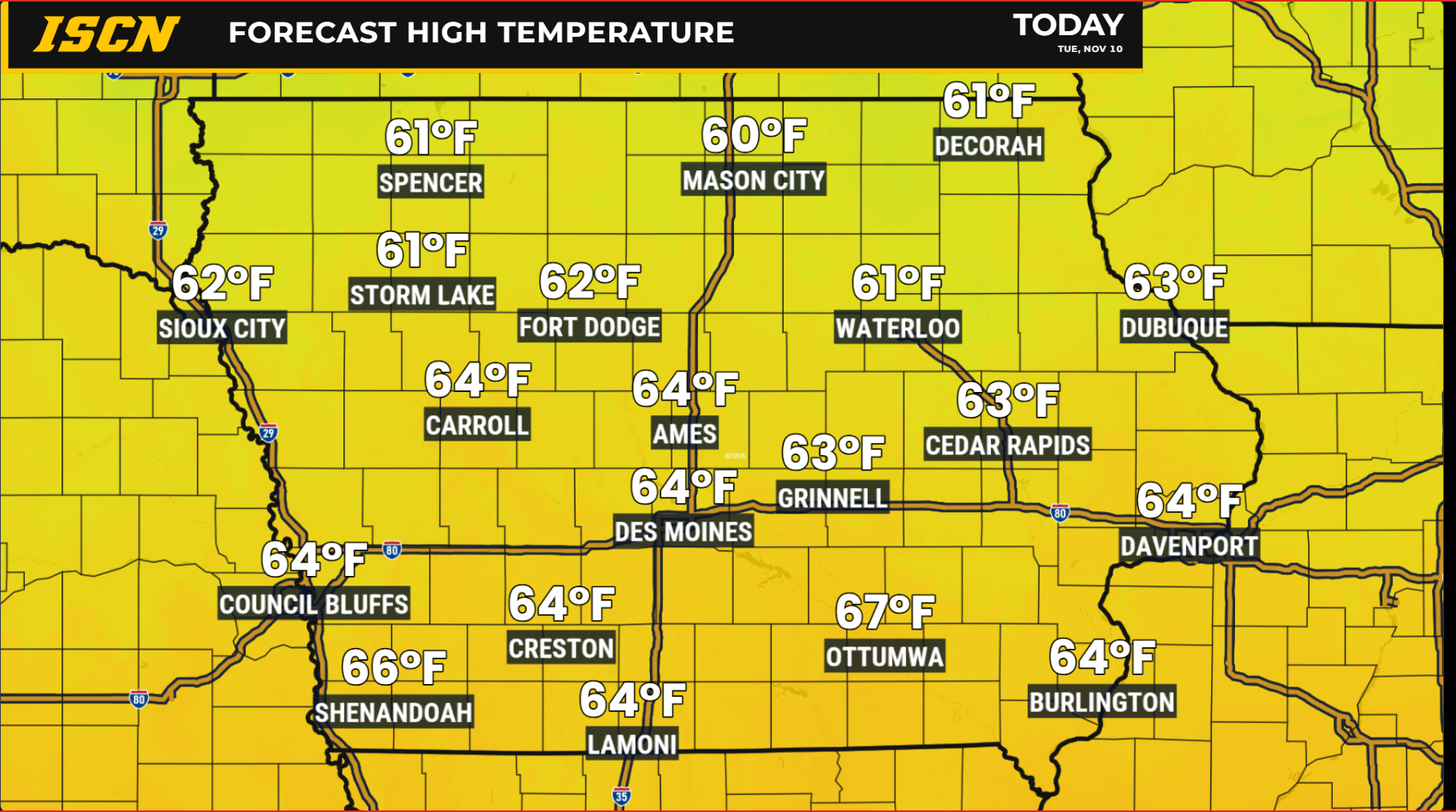
Tuesday will bring another pleasant day across Iowa, with afternoon temperatures reaching the lower to middle 60s in most communities. Des Moines, Ames, Waterloo, Cedar Rapids, Iowa City, Davenport, Council Bluffs, and Sioux City can all expect a relatively mild afternoon compared to what is typical for early November. Parts of far northeastern Iowa may remain in the 50s, but temperatures across the state will generally run above seasonal averages. High pressure moving across the region will keep winds relatively light, with sunshine giving way to some increasing high clouds during the day. No meaningful rainfall is expected, making Tuesday a favorable day for outdoor work, travel, and other activities.
The mild temperatures are being supported by relatively warm air remaining over the central United States, even after a weak cold front moved through Iowa Monday night. That front did little to change the overall temperature pattern, allowing another warm afternoon to develop. Some locations could end up slightly warmer than current forecasts suggest, especially where sunshine lasts longer into the afternoon.
Will It Rain in Iowa Wednesday? Most Areas Stay Dry
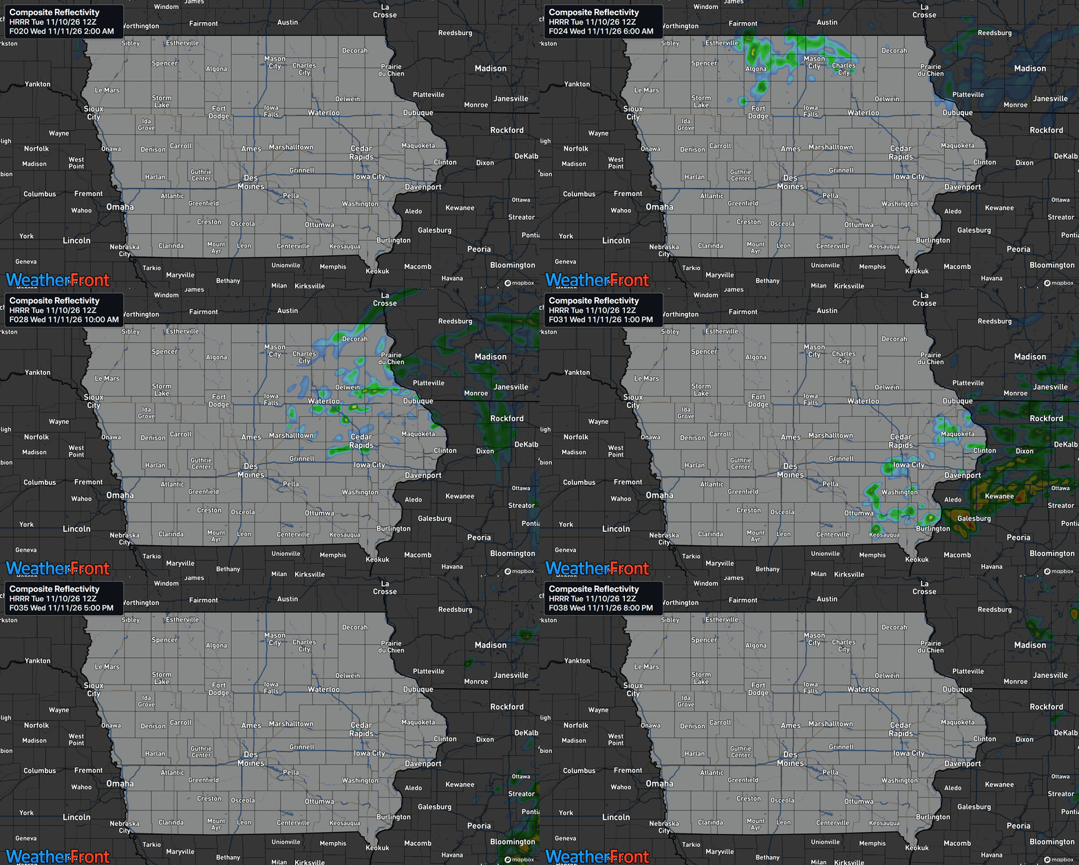
A fast-moving area of low pressure will cross the Upper Midwest late Tuesday night into Wednesday, bringing the next opportunity for rainfall to parts of Iowa. However, this system will have limited moisture available, which should prevent widespread or significant precipitation from developing. The best chances for light rain will be across eastern and northeastern Iowa, including areas near Waterloo, Dubuque, Cedar Rapids, Davenport, and the Mississippi River. Rain chances generally range from 15% to 30% across portions of eastern Iowa, with some areas near the northeastern border having somewhat higher chances of light precipitation. Much of western, central, and southern Iowa will likely remain dry throughout the day.
There is some uncertainty regarding how far south and west the showers will develop. Several short-range weather models suggest that the atmosphere will remain too dry to support much more than isolated sprinkles or brief light showers. The European weather model, however, shows a more developed area of rainfall extending farther into eastern Iowa, with locally greater amounts possible if that solution proves correct. At this point, the lighter and more limited precipitation scenario appears more likely, but forecast confidence in the exact coverage remains lower than confidence in the temperature and wind forecast. Most locations that receive rain should see only light amounts.
Rain should move through fairly quickly, with precipitation chances diminishing by Wednesday afternoon or evening as the system departs. The system’s most noticeable impact across the state will come from the wind rather than precipitation.
Strong Northwest Winds Expected Wednesday Across Iowa
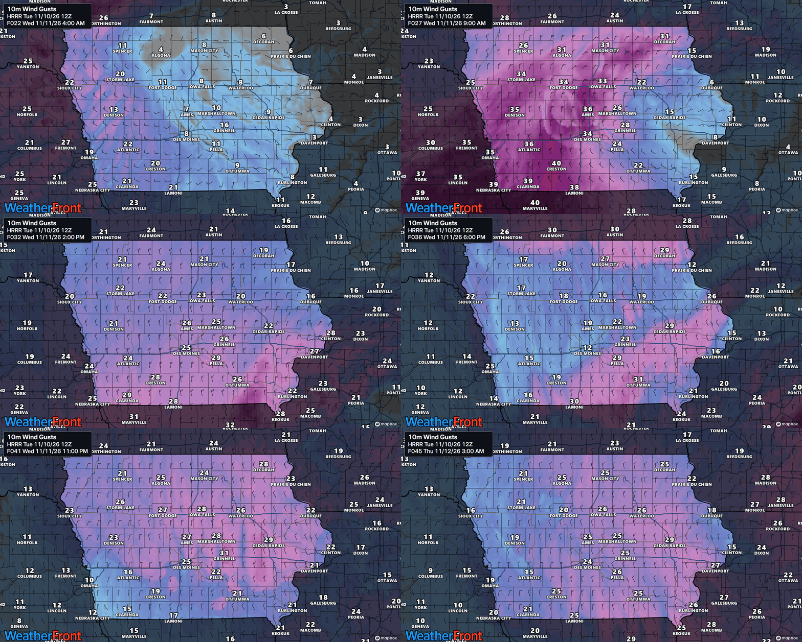
Wednesday will be a much windier day across Iowa as low pressure moves east and colder air begins spreading into the state. Northwest winds are expected to increase during the morning and afternoon, with gusts commonly reaching 25 to 35 mph. Some locations, especially across southwestern Iowa, could experience gusts approaching 40 mph if stronger winds above the ground mix down to the surface. Temperatures will still reach the 50s across much of the state, but the combination of stronger winds and falling temperatures will make conditions feel noticeably cooler than Tuesday. The strongest winds should gradually ease Wednesday evening, although breezy conditions may return Thursday.
Colder Weather Arrives Thursday and Friday With Freezing Temperatures
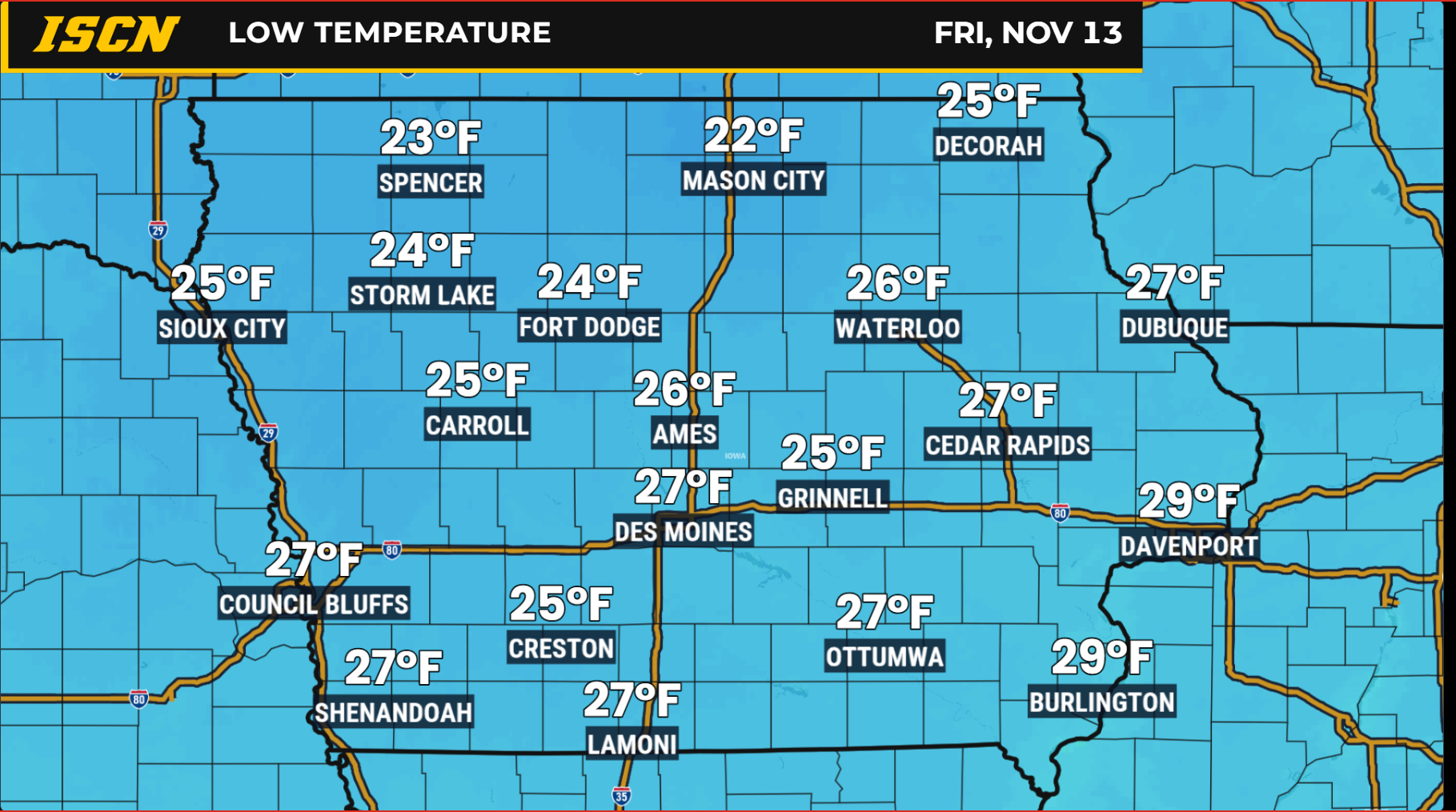
The biggest temperature change of the week will arrive Thursday and Friday as colder Canadian air settles across Iowa. Afternoon highs will generally remain in the 40s, with some northeastern communities potentially struggling to climb much above the upper 30s. This will be a sharp contrast to the 60-degree temperatures expected Tuesday, representing a drop of roughly 15 to 25 degrees in many locations. The colder air will arrive behind Wednesday’s low-pressure system as northwest winds transport air southward from Canada.
Overnight temperatures will become an important part of the forecast, especially for anyone with outdoor plants, exposed plumbing, or temperature-sensitive equipment. Thursday morning lows will range from the upper 20s into the 30s, with even colder readings expected Friday morning. Widespread lows in the 20s are likely Friday, and many communities could experience another freezing morning Saturday. These temperatures will support frost and freezing conditions, especially where skies clear and winds become lighter overnight. Residents who still have sensitive vegetation outdoors should take precautions before the colder weather arrives.
Iowa Weekend Weather Forecast: Slowly Warming Temperatures
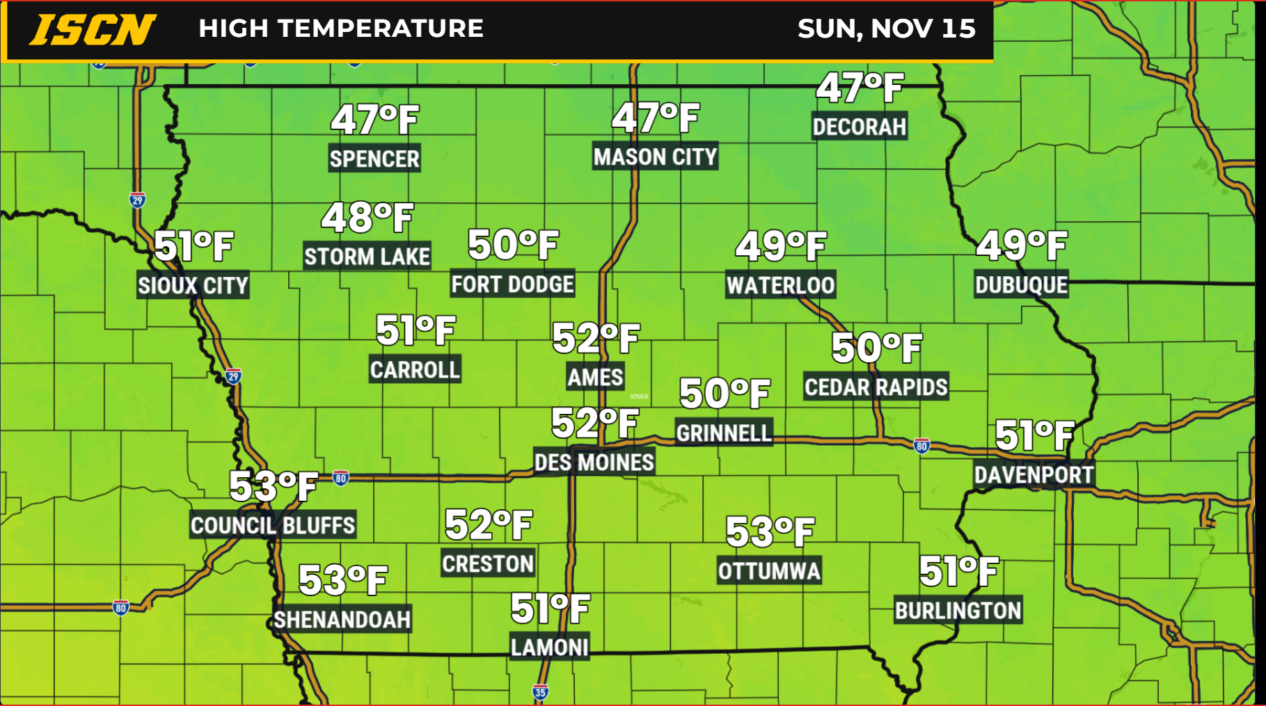
The weekend weather forecast for Iowa is looking generally quiet, with temperatures beginning a gradual recovery after the late-week cold snap. Saturday morning will likely start below freezing in many locations, with lows in the 20s and 30s. Afternoon temperatures should recover into the 40s, although some western and southern communities may approach 50 degrees. High pressure will help keep conditions largely dry, and widespread rain or snow is not expected during the first part of the weekend. Saturday should offer reasonable conditions for outdoor activities, provided residents dress for the chilly temperatures.
Sunday will bring another step toward milder weather as winds begin shifting toward the south and southeast. Afternoon highs should climb into the upper 40s and 50s across portions of Iowa, with western and southern communities having a better opportunity to experience the warmer readings. The warming trend will be gradual rather than dramatic, but temperatures should begin approaching seasonal averages again. Confidence is fairly high in the overall warming trend, although cloud cover and the timing of a possible disturbance could influence temperatures in some locations. Most of the state should continue to experience relatively quiet weather.
There is one forecast feature worth monitoring during the weekend, particularly across southern Iowa. A weak weather disturbance could move from the southern Plains toward the Midwest late Saturday into Sunday, potentially bringing light precipitation closer to the state. Some forecast models keep the system well south of Iowa, while a smaller group of ensemble solutions carries precipitation farther north. Current rain chances are generally around 15% to 30% in areas south of Interstate 80, although confidence in precipitation reaching Iowa remains low. Rain is the favored precipitation type in the available forecast, but the system’s exact track and timing will need to be watched over the coming days.
Extended Iowa Weather Forecast: Above-Average Warmth Returns Next Week
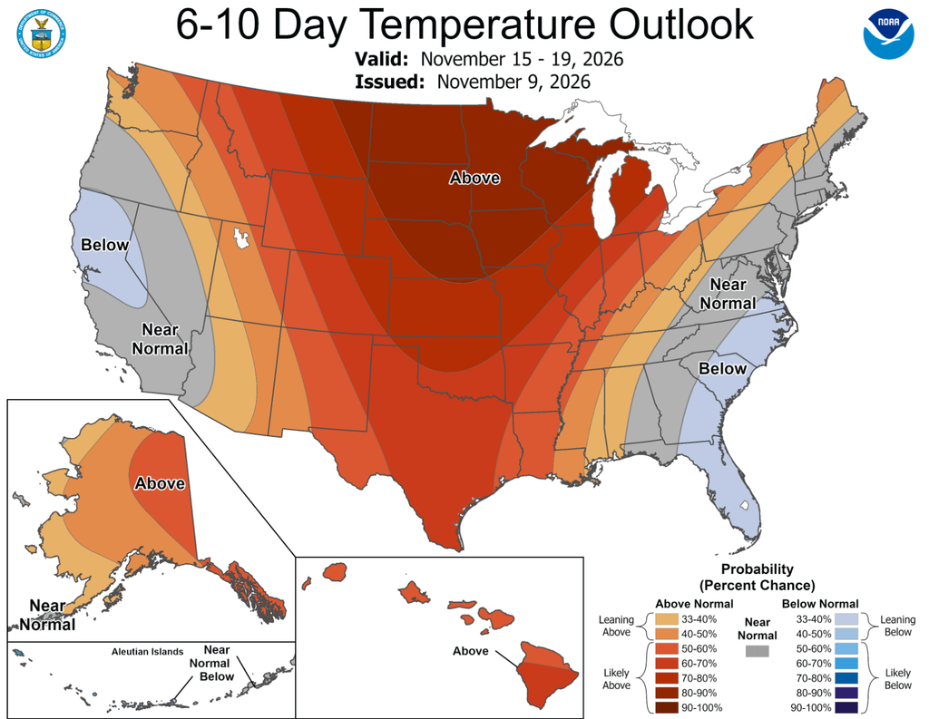
The extended weather forecast for Iowa is increasingly favoring a return to above-average temperatures during the first half of next week. A developing ridge of high pressure in the upper atmosphere is expected to spread eastward across the central United States, allowing milder air to return to the Midwest. High temperatures could climb back into the 50s, with some western and southern locations potentially approaching the upper 50s by Monday or Tuesday. This would bring a noticeable improvement following the colder conditions expected Thursday and Friday. Confidence in the overall warming trend is high, although specific daily temperatures will become clearer as next week approaches.
The Climate Prediction Center’s November 15–19 outlook strongly favors above-normal temperatures across Iowa and much of the Upper Mississippi Valley. Probabilities of warmer-than-average conditions exceed 80% across portions of the northern Plains and Upper Mississippi Valley, reflecting unusually strong agreement among the major ensemble weather models. This does not mean temperatures have an 80% chance of reaching a specific value, but rather that the average temperature during the outlook period is highly likely to exceed the historical average. The broader weather pattern supports that expectation, with upper-level high pressure helping maintain a relatively mild air mass across the region. Forecast confidence for the national 6–10 day outlook is rated well above average, making the warming signal particularly noteworthy.
The warmer pattern is expected to extend beyond the beginning of next week. The November 17–23 outlook continues to favor above-normal temperatures across Iowa, with strong probabilities of warmer-than-average conditions throughout much of the Upper Midwest. This suggests the colder weather arriving later this week may be relatively short-lived rather than the beginning of a prolonged stretch of winter temperatures. However, above-normal temperatures in late November can still include chilly mornings, occasional freezing conditions, and significant day-to-day changes.
Rain Chances Could Increase Across Iowa During the Second Half of November
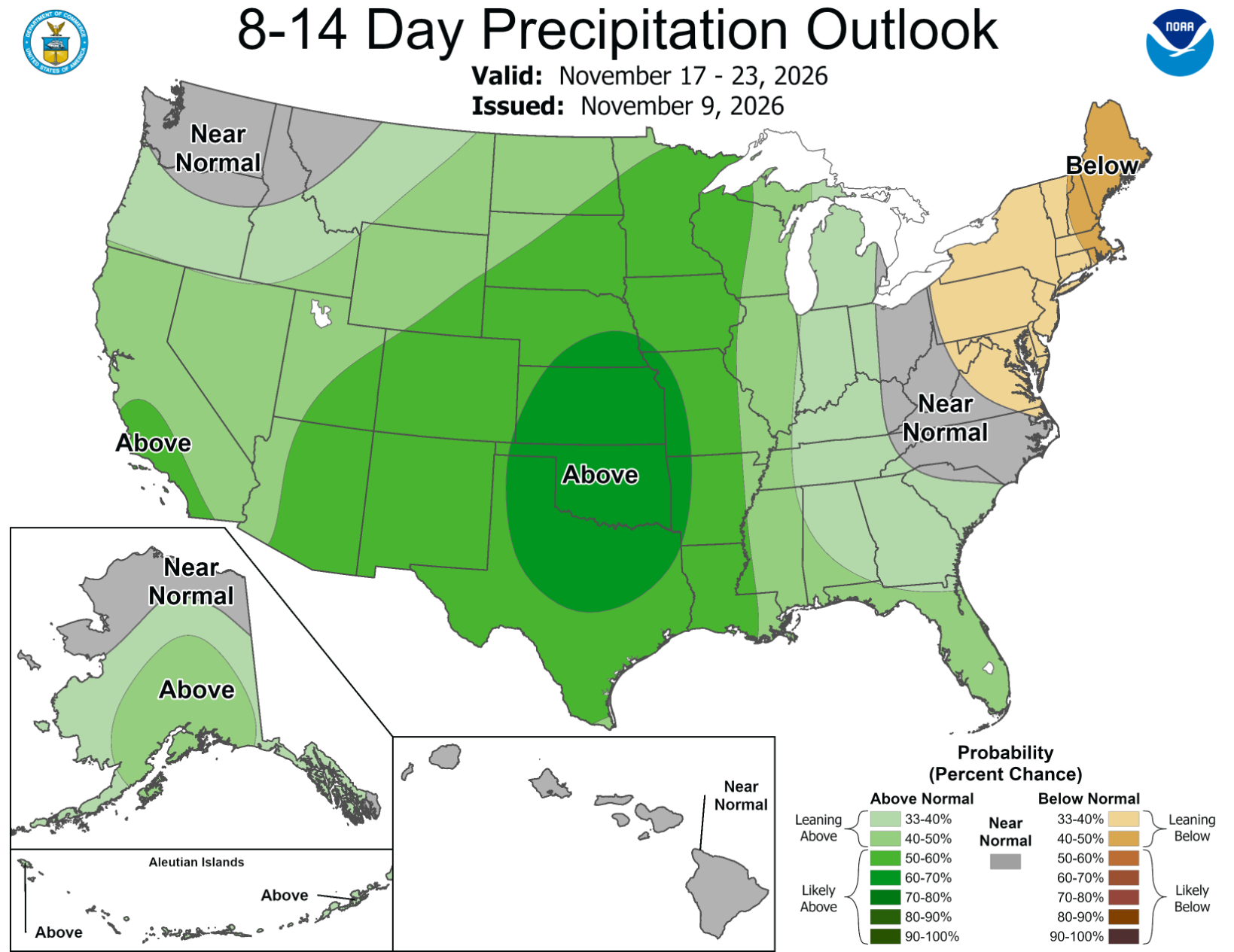
Although Iowa’s short-term weather forecast remains largely dry, the longer-range pattern suggests better opportunities for precipitation could develop during the second half of November. The Climate Prediction Center favors above-normal precipitation across portions of the central United States during both the 6–10 day and 8–14 day forecast periods. This shift is associated with weather disturbances moving inland from the Pacific Ocean and eventually crossing the Plains and Mississippi Valley. As the upper-level weather pattern becomes more active, additional low-pressure systems could develop and bring rain chances into Iowa. Confidence is reasonably high that the broader pattern will become more favorable for precipitation, but the timing and intensity of individual systems remain uncertain.
The November 17–23 outlook is particularly interesting because several ensemble weather models indicate the potential for a more active storm track across the central United States. Some ensemble guidance shows substantial precipitation totals over portions of the broader central U.S., although those amounts should not be interpreted as a specific rainfall forecast for Iowa. The location of individual storm systems will determine which communities receive meaningful precipitation and which remain relatively dry. It is also too early to determine whether colder air could overlap with any future precipitation systems and introduce a chance of snow. For now, the most likely outcome is a warmer pattern with increasing opportunities for precipitation as November progresses.
Stay connected with IowaWeather.com for the latest Iowa weather forecast, live weather radar, changing temperature trends, and updates on developing weather systems. You can also follow the Iowa Storm Chasing Network and use the ISCN Weather app to monitor conditions across the state as the forecast changes.