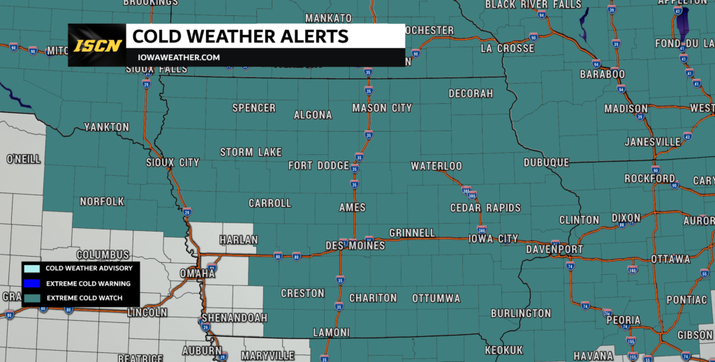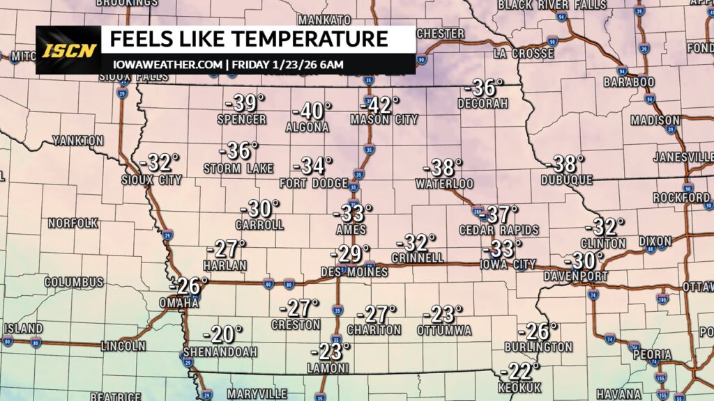
An Extreme Cold Watch has now been expanded to include much of Iowa, as confidence continues to increase in a significant Arctic outbreak late this week. Dangerously cold wind chills are possible from late Thursday night through early Saturday, with the most severe conditions expected overnight Thursday into Friday morning.
Wind chills could drop to 30 to 45 degrees below zero, especially across northern Iowa, with slightly less extreme—but still dangerous—values farther south. Anyone who lives, works, or travels in Iowa should begin preparing now for potentially life-threatening cold.
What We’re Seeing Right Now
Based on the data we’re reviewing this morning, confidence is growing that a true Arctic air mass will settle across the state late this week. Multiple forecast models remain in strong agreement on both the timing and intensity of the cold, with only minor differences in how low wind chills ultimately fall in specific locations.
What stands out most is the combination of two critical factors arriving at the same time:
- A fresh surge of Arctic air with temperatures well below zero
- Persistent northwest winds, keeping wind chills dangerously low even during daylight hours
We’ve seen similar setups in Iowa before. When the core of the cold aligns with sustained wind, conditions can deteriorate quickly. At this point, we have moderate to high confidence that large portions of Iowa will experience wind chills capable of causing frostbite in minutes—not hours.

Timeline & Key Windows
Wednesday
- Strong northwest winds develop during the day.
- Wind Advisories are in effect across much of Iowa.
- Blowing snow may reduce visibility at times, especially in open country and along east-west roads.
- These winds will set the stage for how dangerous the cold will feel later in the week.
Thursday Afternoon – Evening
- Temperatures continue to fall through the day.
- Wind chills drop sharply by evening as Arctic air settles in.
- Outdoor conditions begin turning hazardous.
Late Thursday Night through Friday Morning (Highest Concern)
- Wind chills potentially 30 to 45 below zero, coldest in northern Iowa.
- Exposed skin can be affected in as little as 10 minutes.
- This is the most likely window for school delays, cancellations, and operational disruptions.
Friday Afternoon into Early Saturday
- Still extremely cold statewide.
- Wind chills may improve slightly during the day Friday but remain dangerous.
- Overnight lows into early Saturday remain a concern before gradual moderation begins.
The worst-case scenario would involve slightly stronger winds than currently forecast, which would drive wind chills even lower. The most likely scenario still supports widespread dangerous cold across Iowa.
Primary Risks & Impacts
This type of cold affects far more than just how it feels outside.
For Families and Schools
Bus stops can become dangerous very quickly, especially for young children. Frostbite can develop faster than most people realize, sometimes in just minutes. If wind chills approach warning levels, schools may need to adjust schedules, limit outdoor exposure, or consider closures.
For Commuters
Extreme cold increases the likelihood of vehicle issues, especially with weaker batteries. Any breakdown becomes far more serious when wind chills are this low. Blowing snow on Wednesday may also leave behind drifting, particularly on rural roads.
For Homes and Businesses
Heating systems will run nearly nonstop, increasing strain on furnaces and boilers. Frozen pipes become a real concern, especially in exterior walls, crawl spaces, or unheated areas. Even brief power interruptions can become critical very quickly.
For Agriculture and Livestock
Livestock will experience significant cold stress without proper wind protection. Water sources can freeze faster than expected, even with heaters in place, requiring close monitoring.
What You Should Do
Based on our experience covering cold outbreaks in Iowa, preparation before the cold arrives makes all the difference.
If you’ll be outside at all:
Cover all exposed skin, as wind chills this low often cause damage before you realize it’s happening. Limit time outdoors as much as possible, especially overnight and during the early morning hours when conditions are typically at their worst.
For drivers:
Keep your fuel tank at least half full to reduce the risk of fuel line issues and ensure you have heat if stranded. If traveling longer distances, carry a winter emergency kit and plan ahead. Let someone know your route and expected timing if you must travel late at night or early in the morning, when assistance may be delayed.
For homeowners:
Check furnace operation now rather than waiting for the coldest night, when service may be harder to obtain. Open cabinet doors under sinks along exterior walls to allow warm air to circulate and help prevent frozen pipes. If using space heaters, do so safely and keep them well clear of flammable materials.
For parents:
Plan ahead for possible school schedule changes or delays as conditions worsen. Make sure children are properly layered if they will be waiting outdoors, even briefly, as exposure can become dangerous very quickly.
For businesses:
Review cold-weather staffing plans and building access procedures in advance. Ensure employees who work outdoors have access to warming breaks, appropriate protective gear, and clear safety guidance to limit cold-related risks.
What We’ll Be Watching Next
Over the next 24 hours, we’ll be closely monitoring:
- Whether wind speeds trend slightly higher or lower
- How quickly the Arctic air deepens Thursday evening
- Whether parts of Iowa are upgraded from an Extreme Cold Watch to a Warning
Small changes in wind speed can have a big impact on wind chill values, and we’ll continue refining the forecast as higher-resolution data becomes available.
Our next detailed update will be issued as confidence sharpens on exact timing and severity for specific communities.
For the latest updates, visit iowaweather.com and follow ISCN on social media for real-time alerts and safety tips.