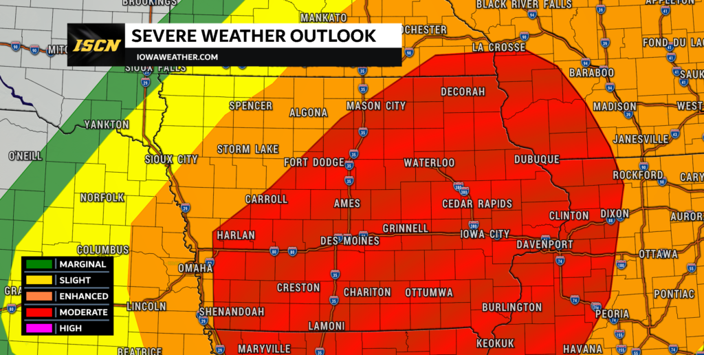
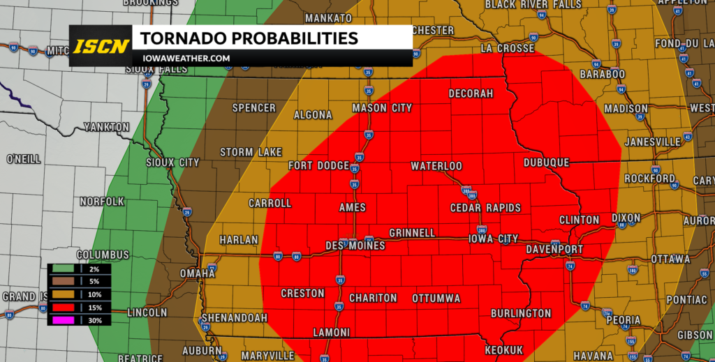
Moderate Risk of Severe Weather in Iowa Tuesday May 21st, 2024

As the spring storm season ramps up, Iowa is bracing for a significant severe weather event today, May 21, 2024. The Storm Prediction Center has issued a Moderate Risk for severe thunderstorms, highlighting a heightened threat across the region. This alert emphasizes the potential for strong tornadoes, large hail, and damaging winds, urging residents to prepare and stay informed.
Timing and Threats
The key timeframe for severe weather on Tuesday is from mid-afternoon into the early evening. The expected severe weather conditions include:
- Tornadoes: There’s a 15% hatched probability for tornadoes, meaning there’s a significant chance for EF-2 or stronger tornadoes. These tornadoes can cause extensive damage to homes, vehicles, and infrastructure.
- Large Hail: Hailstones could exceed 2 inches in diameter, potentially causing damage to roofs, windows, and vehicles.
- Damaging Winds: Wind gusts could reach 60 to 75+ mph, capable of downing trees and power lines, and causing structural damage.

Potential Mitigating Factors
While the severe weather risk is substantial, certain factors could mitigate convection tomorrow:
- Morning Convection: Early storms might stabilize the atmosphere, leaving less time for recovery before the afternoon storms.
- Boundary Shifts: Morning storms could push the boundary southward, shifting the severe weather threat out of the area.
Despite these possibilities, the overall risk remains high. The mesoscale environment will be closely monitored for any impacts on storm development and mode. Additionally, afternoon thunderstorms could worsen flooding from morning storms.
Preparation Tips
Given the severity of the forecast, it’s crucial for residents to take the following precautions:
- Stay Informed: Regularly check weather updates from reliable sources. Utilize weather apps that offer real-time alerts.
- Identify Safe Shelter: Ensure you have access to a sturdy shelter. If your home does not have a safe room, identify the nearest storm shelter in your community.
- Prepare an Emergency Kit: Have essentials ready, including water, non-perishable food, a flashlight, batteries, a first-aid kit, and necessary medications.
- Secure Outdoor Items: High winds can turn outdoor furniture and other objects into dangerous projectiles. Secure or bring these items indoors.
- Review Your Emergency Plan: Make sure all family members know the plan, including where to go for shelter and how to stay in touch.

As one of the first high-end severe weather events of the season, it is essential to take these warnings seriously. Preparation and vigilance can significantly reduce the risks associated with severe weather. Stay safe, stay informed, and be ready to act if conditions deteriorate.
For continuous updates and more detailed information, follow local weather channels and visit the Storm Prediction Center’s website and IowaWeather.com.
Stay alert, Iowa, and be prepared for what Mother Nature has in store this Tuesday.