Second Winter Storm Follows in Blizzard’s Wake: More Snow for Iowa Thursday into Friday
Iowa is gearing up for another round of winter weather as a storm system moves into the state late Thursday into Friday. While the impacts will vary across different regions, accumulating snowfall, gusty winds, and potential travel disruptions are all on the table. Here’s what you need to know about the upcoming winter weather event.
Storm Setup and Timeline
The system responsible for the incoming snowfall is currently moving southeast from Montana and will interact with a strengthening low-pressure system developing in the central Rockies. This setup will lead to increased moisture being funneled into the Upper Mississippi Valley, with snow expected to begin in northern Iowa by late Thursday evening.
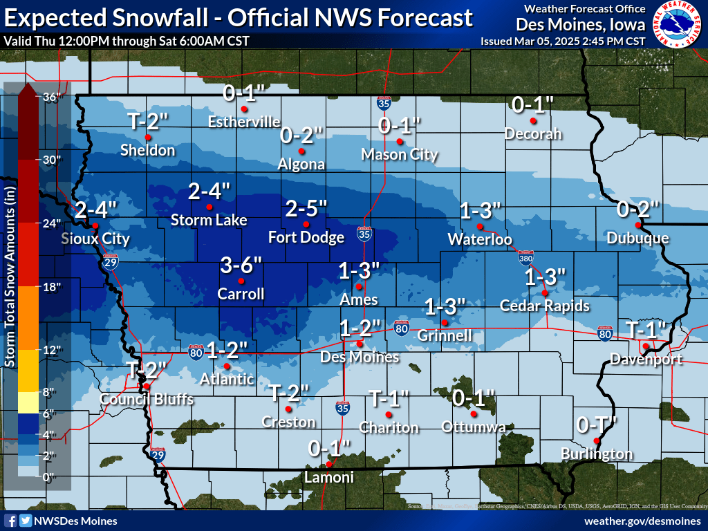
Initially, precipitation will be limited due to dry air in the lower atmosphere. However, as moisture increases and the system strengthens, snowfall rates will pick up, especially overnight Thursday into Friday morning. The heaviest snowfall is expected in north-central Iowa, with lighter amounts further south due to warmer temperatures allowing for a rain-snow mix.

Snowfall Accumulations and Regions Impacted
- North-Central Iowa (North of I-80, especially near Highway 20): 4-6 inches of snowfall expected. Localized areas may receive even higher amounts due to strong atmospheric lifting and enhanced snow growth.
- Central and Southern Iowa (Including Des Moines and areas south of I-80): A mix of rain and snow, with snowfall totals of 1-2.5 inches. Higher accumulations are expected along Highway 30.
Key Weather Concerns
- Snowfall Rates: In areas north of I-80, high snowfall rates of 1 inch per hour may occur overnight Thursday into Friday morning, leading to rapid accumulations.
- Blowing and Drifting Snow: Winds of 20-25 mph could cause some drifting, though not as severe as the previous blizzard conditions.
- Road Conditions: Snow-covered and slick roads will be a concern, particularly during the Friday morning commute. Travel may be hazardous in areas receiving the highest snowfall amounts.
- Temperature Impacts: Overnight lows will dip near or just below freezing, which will help with snow accumulation in northern areas, while daytime melting may limit accumulations further south.
Final Thoughts and Preparations
While this system is not expected to reach the intensity of the recent blizzard, it will still bring impactful winter weather to much of Iowa. The National Weather Service is likely to issue winter weather advisories or warnings once the current storm system clears out. If you have travel plans for Thursday night into Friday, be prepared for snow-covered roads and reduced visibility in areas north of I-80.
Stay tuned for updates as forecasts become more refined, and as always, follow IowaWeather.com for the latest storm coverage and alerts!