Severe Storms and Flash Flooding Possible Monday Across Iowa

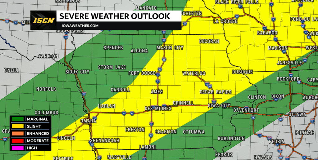
A potent combination of extreme heat, high humidity, and a stalled frontal boundary will set the stage for potentially dangerous weather across Iowa on Monday, June 24. Multiple rounds of thunderstorms are expected to develop across the state, bringing the risk of severe weather during the afternoon and evening hours. Along with damaging winds and large hail, there is also the potential for isolated tornadoes and flash flooding as the week begins.
Storms Likely to Develop by Afternoon
As daytime heating ramps up on Monday, instability will surge across central and southern Iowa. Energy available for storms (CAPE) is expected to climb into the 2,000–3,000 J/kg range, creating an environment favorable for thunderstorm development. A frontal boundary stalled across the state will act as the main trigger, with storms likely to form along and just south of this zone.
While wind shear won’t be overly impressive, there will be just enough directional and speed change with height to support organized multicell storms. These storms could grow quickly, especially during the peak heating hours of the afternoon and early evening. The main threats will be damaging winds and large hail, but there is also a narrow window for an isolated tornado, particularly near the surface boundary where wind shifts can enhance low-level rotation.
Flash Flooding Is a Concern
Flash flooding will be a concern across much of Iowa on Monday as deep tropical moisture surges into the region. With extremely high atmospheric moisture levels—some of the highest we’ve seen this June—thunderstorms will be capable of producing torrential rainfall in a short period of time. Forecast models are showing precipitable water values exceeding 2 inches, which means storms will be very efficient rain producers.
Because of a stalled frontal boundary draped across the state, storms may repeatedly form and track over the same areas, a process known as “training.” This significantly increases the risk for flash flooding, especially in areas that see multiple rounds of thunderstorms. While the southwest part of the state may be more favored for higher rainfall totals early in the day, the flood threat extends into central, southern, and even parts of eastern Iowa as storms shift and evolve through the evening and overnight hours.
Urban areas, low-lying spots, and locations with poor drainage will be especially vulnerable to rapid water accumulation. Rainfall totals of 2 to 4 inches are possible in some areas, and localized amounts may be even higher where storms repeatedly track over the same location. With additional storms possible through midweek, Monday’s rainfall will also set the stage for longer-term river and stream flooding in the days that follow.
Eastern Iowa: Watching the Southward Shift
In eastern Iowa, storm development will depend on how far east the boundary sags by the afternoon. There is a chance that storms fire as far east as the Cedar Rapids and Dubuque areas, especially after 2 PM. Instability could be extreme here as well, with models hinting at CAPE values exceeding 4,000 J/kg in some spots.
Initially, any storms that form are likely to move slowly. However, as cold pools develop within these storm clusters, there’s a good chance they could start to push southward into the I-80 corridor through the evening hours. If that shift occurs, parts of eastern Iowa could also see heavy rainfall and localized flooding concerns.
Dangerous Heat Adds to the Threat
Before storms even arrive, a significant heat wave will remain in place across southeastern Iowa. Heat index values are expected to climb above 100°F in some areas during the afternoon, continuing a stretch of oppressive weather that began over the weekend. Overnight lows will again struggle to dip below the upper 70s, meaning there will be little relief from the heat until storms begin to roll through.
The heat will likely increase the stress on vulnerable individuals and could amplify the impacts of any power outages caused by storms. Monday will be a day to take extra precautions outdoors and stay cool until storms bring temperatures back down.
We’ll be tracking Monday’s storms in real time across our platforms, with radar updates, live streams, and field reports as the situation evolves. Stay tuned to IowaWeather.com and our social channels for the latest.