If you’ve been on Facebook lately, you’ve probably seen posts or shared images calling for a major winter storm around Thanksgiving. Many of these maps show big snow totals over the Midwest, including Iowa, and naturally, they’ve gotten a lot of attention.
But here’s the truth, those posts started circulating 10+ days out, and most were based on single model runs — the least reliable type of long-range weather information. As we get closer to the Thanksgiving holiday, it’s time to clear up what’s real, what’s rumor, and what you can expect for travel across Iowa.
Long-Range Storm Rumors: Why They Spread and Why They’re Misleading
Forecast models beyond 7–10 days simply do not have the accuracy needed to pinpoint a storm track, timing, or snowfall amounts. That means a single model run can easily show a big snowstorm one day…and show nothing the next day.
Some social media pages share these dramatic maps for clicks, but meteorologists focus on patterns, not one-off images.
Now that we are almost a week out, models are still inconsistent — which is normal. They continue to flip and flop on the potential track and strength of a system that may develop sometime between November 30 (Sunday) and December 2.

What the Climate Prediction Center Is Saying
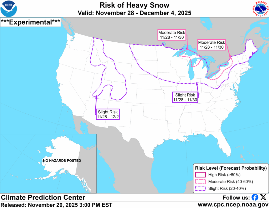
The Climate Prediction Center (CPC) currently shows a 20–40% “slight risk” of heavy snow for parts of the Upper Midwest, including most of the northern half of Iowa, during this period.
Here is what that means in simple terms:
The CPC uses three main criteria to define “heavy snow”:
- Snowfall is unusually high for this time of year.
– Specifically, snowfall ranks above the 85th percentile compared to what normally falls during late November/early December. - Snow contains at least 0.5” of liquid water equivalent.
– This is basically the amount of moisture in the snow. Wetter snow has more moisture; drier, fluffier snow has less. - Temperatures look supportive for snow.
– Meaning atmospheric temperatures would be cold enough for snow, not rain.
They also use a newer probabilistic snow-water-equivalent tool that blends multiple model datasets to estimate the chance of impactful snow.
In plain English, this does not mean a big storm is guaranteed — only that the pattern is favorable for a storm if everything comes together. It’s a heads-up, not a prediction of amounts.
Why Meteorologists Don’t Talk Snow Totals This Far Out
As we get closer to any potential weather event, the confidence in specific details increases. Here’s how the timeline typically works:
7+ Days Out (Where We Are Now)
- Only talk about large-scale patterns (cold air, active storm track, etc.)
- No specific snowfall amounts
- No exact track or timing
- Messaging: “A system is possible, but details are highly uncertain.”
5–6 Days Out
- Look for updates to the trends
- Models often are still shifting drastically
- Still too early for amounts or hour-by-hour timing
3–4 Days Out
- General timing becomes clearer (which time of day, roughly what part of the state)
- Still avoid exact totals, but we start narrowing ranges (start using terms like light, moderate, or heavy snow possible)
1–2 Days Out
- This is when snowfall amounts, timing, and impacts become reliable
- Fine details such as banding, dry slots, and wind direction come into focus
We are still too far out to talk accumulation forecasts for any post-Thanksgiving system. Model disagreement is still large, and it will likely take until early to mid next week before confidence improves.

What Does Look More Certain: Colder Air Arriving for Thanksgiving
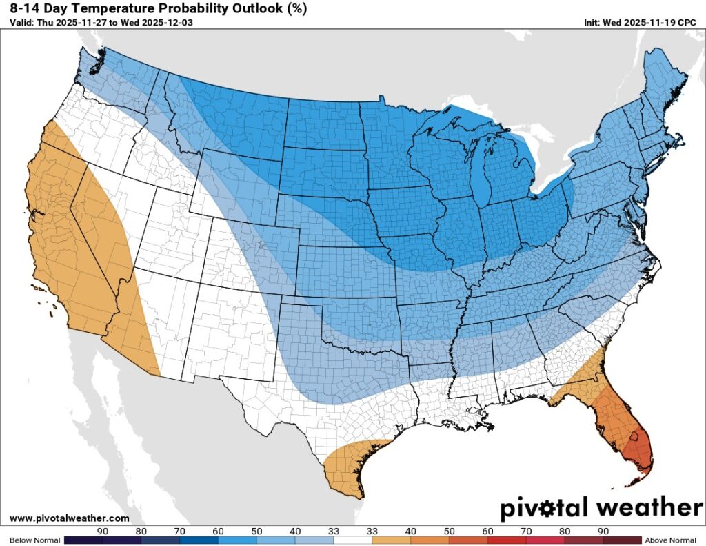
While the possible storm remains uncertain, the arrival of colder air is looking more likely.
Here’s what to expect:
- A colder air mass pushes into Iowa late Tuesday (Nov. 25) into Wednesday (Nov. 26).
- Temperatures will drop to 10–15° below normal for late November.
- Normal highs this time of year are in the mid-30s to low-40s.
- Expect highs starting Wednesday in the upper 20s to 30s, and these highs will continue throughout the Thanksgiving holiday weekend.
It won’t be “arctic cold,” but because we’ve been running well above normal this month, the drop will feel more dramatic.

Strong Winds Ahead of Thanksgiving
Along with the colder air, winds will ramp up significantly.
- Wind gusts increase late Tuesday into Wednesday.
- Widespread gusts of 30–40 mph are possible.
- Winds diminish during the day Thursday (Thanksgiving).
Bottom Line
Here’s what you should take away heading into Thanksgiving week:
✔️ A storm system after Thanksgiving is possible but still highly uncertain.
✔️ Colder weather is more likely for Thanksgiving.
✔️ Strong winds are expected Wednesday before Thanksgiving.
✔️ Storm system details will not be reliable until mid next week.
We’ll continue to monitor trends and keep you updated with accurate, hype-free information as confidence grows.