What Is a Derecho? 2025 Updated Criteria
You’ve probably heard the term “derecho” tossed around in storm season—especially in places like Iowa and the Midwest. But what actually qualifies as a derecho?
In January 2025, meteorologists officially updated the definition of a derecho to better reflect which storm events are truly the most damaging. The change comes from the American Meteorological Society and a team of researchers from the NOAA Storm Prediction Center and the University of Oklahoma (Squitieri et al., 2025).
Let’s break it down in a way that makes sense—without all the scientific jargon.
What’s the New Definition?
The updated definition says a derecho is:
“A widespread severe windstorm characterized by a family of destructive downbursts containing hurricane-force gusts, associated with a cold-pool-driven mesoscale convective system.”
— (Squitieri et al., 2025, p. E101)
Put simply: it’s a long-lived thunderstorm system that causes widespread wind damage and includes hurricane-force gusts (at least 75 mph).
New Derecho Requirements in 2025
Here’s what a thunderstorm event now must meet to be classified as a derecho:
- It must be part of a cold-pool-driven thunderstorm system (the storm is powered by a pool of cold air spreading out across the surface).
- The wind damage path must be at least 400 kilometers long (about 250 miles).
- There can’t be gaps longer than:
- 1 hour between damaging wind reports
- 200 kilometers (about 125 miles) between those reports
- The storm must produce:
- At least five gusts of 75+ mph (33 m/s), spaced 80 km (50 mi) apart
- At least three of those gusts must be measured (not just estimated)
(Squitieri et al., 2025, p. E101)
Why Change the Definition?
Before now, there was no single, consistent definition of a derecho. Different meteorologists used different criteria, which made it hard to track these storms accurately or compare them over time.
The new definition aims to:
- Focus on high-impact events (not every strong thunderstorm)
- Identify storms caused by specific physical processes, not just storms that look big
- Prevent confusion between derechos and other types of storm systems, like cold-season squall lines driven by larger weather patterns (Squitieri et al., 2025, pp. E91–E94)
How Scientists Came Up with This
Researchers analyzed nearly 24 years of storm data (2000–2022), including over 18,000 long-lived thunderstorm systems. Using radar, wind reports, and storm motion analysis, they applied different definitions and tested which ones captured the most intense, widespread wind damage.
Their conclusion:
The most reliable indicator of a derecho is a cold-pool-driven storm that travels fast, stays organized, and produces multiple hurricane-force wind gusts across a long path. (Squitieri et al., 2025, pp. E95–E100)
Why This Matters for the Public
By narrowing the definition, meteorologists can:
- Improve forecasts for truly dangerous windstorms
- Help emergency managers and the public prepare when one is coming
- Track long-term trends in the most damaging types of thunderstorms
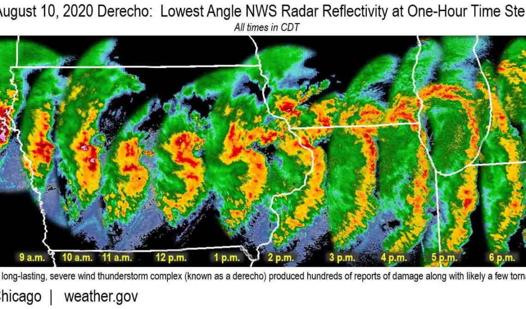
A more focused definition helps make sure “derecho” is only used when it really matters—like the Iowa derecho of August 2020, which left over a million people without power and caused billions in damage.

Key Takeaway
Not all thunderstorm wind events are created equal. With this new 2025 update, you can be confident that when meteorologists say “derecho,” they mean a high-impact, well-organized, and scientifically distinct windstorm.
So next time it pops up in the forecast, you’ll know: it’s not just a big storm—it’s the real deal.
Sources:
- Squitieri, B. J., Wade, A. R., & Jirak, I. L. (2025). On a Modified Definition of a Derecho. Part I: Construction of the Definition and Quantitative Criteria for Identifying Future Derechos over the Contiguous United States. Bulletin of the American Meteorological Society. https://doi.org/10.1175/BAMS-D-24-0015.1
- American Meteorological Society. (2024). Glossary of Meteorology.