What Is a Panhandle Hook?
Panhandle Hook storms are among the most significant cold-season weather systems in the central United States. These low-pressure systems form near the Texas and Oklahoma Panhandles and then “hook” northeast, often producing heavy snow, blizzard conditions, and high-impact winter weather across the Plains, Midwest, and Great Lakes.
This guide explains what a Panhandle Hook is, how it forms, why it produces such intense weather, and what regions should expect when one develops.
What Is a Panhandle Hook?
A Panhandle Hook is a type of winter storm that develops in the Texas and Oklahoma Panhandles before curving northeast toward the Midwest and Great Lakes. The term comes from the storm’s hook-shaped track, which resembles a fishing hook on weather maps.
These storms can bring:
- Heavy snow and blowing/drifting snow
- Blizzard-level winds
- Rain, sleet, or freezing rain on the warm side
- Thunderstorms in the warm sector
- Rapidly changing travel conditions
Panhandle Hooks are notable because they combine abundant Gulf moisture, strong upper-level forcing, and a sharp temperature gradient—a recipe for high-impact weather.
How a Panhandle Hook Forms (Meteorology Explained Simply)
Panhandle Hooks form through a process called lee-side cyclogenesis, which happens on the east side of the Rocky Mountains. Here’s how it works:
Step-by-Step Development
- Cold, dry air slides south from Canada.
- Warm, moist air surges north from the Gulf of Mexico.
- The jet stream dips over the Southwest, providing lift and spin.
- A new low-pressure system develops in the Texas/Oklahoma Panhandle region.
- As the system intensifies, it curves northeast—creating the signature “hook.”
Why It Produces Heavy Snow
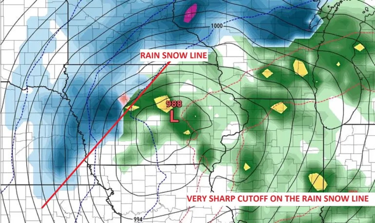
Areas northwest of the low experience:
- Strong lift
- Cold air
- Deep moisture
This combination creates intense snowfall, often with narrow bands of extremely heavy snow known as mesoscale snow bands.
Typical Track and Regions Most Affected
While each storm is unique, Panhandle Hooks usually follow a recognizable path:
Texas/Oklahoma Panhandles → Kansas → Nebraska/Iowa → Midwest → Great Lakes
Commonly affected states include:
- Iowa
- Minnesota
- Wisconsin
- Illinois
- Missouri
- Michigan
If the low tracks slightly west or east, the placement of rain, snow, and ice can change dramatically—one of the biggest forecasting challenges.
Weather Hazards Associated With Panhandle Hooks
Panhandle Hooks can produce multiple hazards at once:
Heavy Snow & Blizzards
The cold northwest quadrant of the storm favors:
- 6–12+ inches of snow
- Whiteout conditions
- Drifting snow due to strong winds
- Blizzard warnings when wind gusts exceed 35 mph with low visibility
Ice Storms & Mixed Precipitation
The warm side of the system may experience:
- Freezing rain
- Sleet
- Heavy rain that transitions to snow
Severe Weather
Though it surprises some people, Panhandle Hooks can also trigger thunderstorms or isolated severe weather, especially along the warm front.
Great Lakes Enhancement
As the storm passes the Great Lakes, lake-effect processes can significantly boost snowfall totals.
Historical Panhandle Hook Storms
Several Panhandle Hooks rank among the most memorable winter storms in U.S. history:
The Armistice Day Storm (1940)
A rapidly intensifying storm that caused heavy snowfall, blizzard conditions, and more than 140 fatalities.
The Edmund Fitzgerald Storm (1975)
A strong Panhandle Hook that produced hurricane-force winds on Lake Superior, contributing to the sinking of the SS Edmund Fitzgerald.
These events highlight the destructive potential of Panhandle Hooks and why they are closely monitored.
How Meteorologists Forecast Panhandle Hooks
Forecasting these storms requires analyzing:
- Jet stream position
- Surface low development
- Temperature gradients
- Gulf moisture availability
- Model agreement on storm track
Because a shift of just 50–100 miles drastically changes storm impacts, meteorologists often emphasize uncertainty early in the forecast.
For residents, monitoring updates from trusted local sources—especially as the storm approaches—is essential.
FAQs About Panhandle Hooks
What causes a storm to “hook”?
The hook shape comes from the low-pressure system turning northeast after forming near the Panhandles due to upper-level winds and temperature gradients.
How common are Panhandle Hooks?
They typically occur several times each winter, especially from November through March.
What states get hit the hardest?
Iowa, Minnesota, Wisconsin, Illinois, and Michigan frequently experience the heaviest snowfall.
Can a Panhandle Hook cause severe weather?
Yes. The warm side of the system can produce thunderstorms or even isolated severe weather outbreaks.
How is a Panhandle Hook different from an Alberta Clipper?
Panhandle Hooks are moisture-rich and slow-moving, producing heavy snow; Alberta Clippers are fast, originate in Canada, and typically produce lighter snowfall.
Are Panhandle Hooks becoming more intense due to climate change?
Research is ongoing. Some studies suggest increased moisture availability could enhance heavy-snow events, but long-term trends remain uncertain.
