Iowa Weather: Winter Weather Advisory Issued Thursday

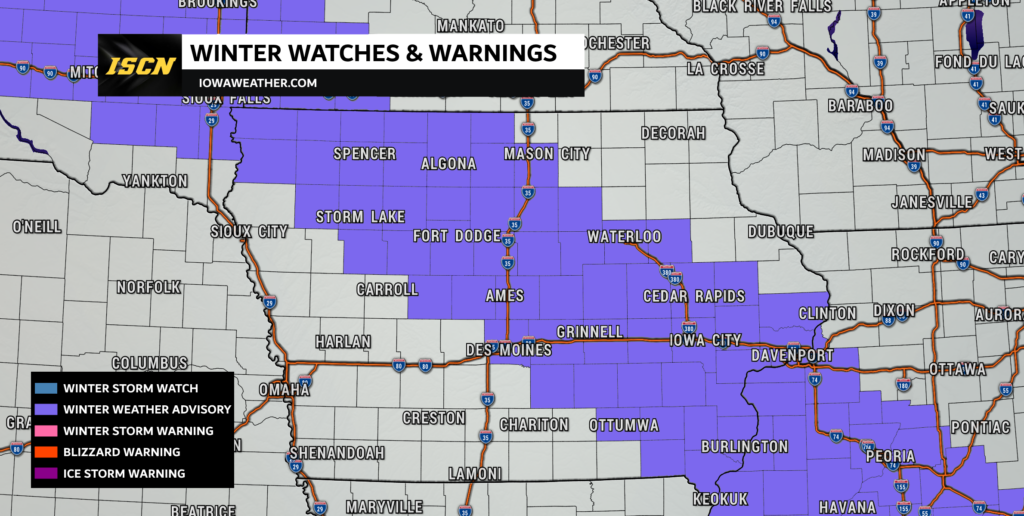
A widespread Winter Weather Advisory has been issued across Iowa as a fast-moving winter system brings a combination of snow, sleet, and freezing rain to the state today and tonight. Three National Weather Service offices—Des Moines, Sioux Falls, and the Quad Cities—are covering different sections of the state, but all warn that travel could become hazardous, especially during the Thursday evening commute.
This system is expected to impact nearly every major population center in northern, central, and eastern Iowa, creating challenging travel conditions as precipitation types change through the day.
Advisory Timing by Region
One of the key aspects of this storm is its staggered timing, as the system tracks from northwest to southeast across Iowa.
Northwest Iowa: 6 AM – 6 PM Today
Wintry precipitation began early this morning in far northwest Iowa, where a mix of snow, sleet, and freezing rain will continue into the early evening. This region will experience the longest duration of mixed precipitation, including the greatest chance for icing early in the day.
Central & Northern Iowa: Noon – Midnight
Precipitation will push into central Iowa around midday and continue through the evening. Areas such as Fort Dodge, Ames, Mason City, Waterloo, and surrounding communities will see snow develop first, with the potential for pockets of freezing drizzle or mixed precipitation as temperatures hover near freezing late this afternoon and evening.
East-Central & Southeast Iowa: 1 PM – 3 AM Friday
Eastern Iowa will be the last to see the system arrive, with snow and periods of mixed precipitation developing mid-afternoon. Cedar Rapids, Iowa City, Davenport, Muscatine, and surrounding areas could experience accumulating snow into the overnight hours, with snowfall lingering longer than in central Iowa.

Expected Precipitation
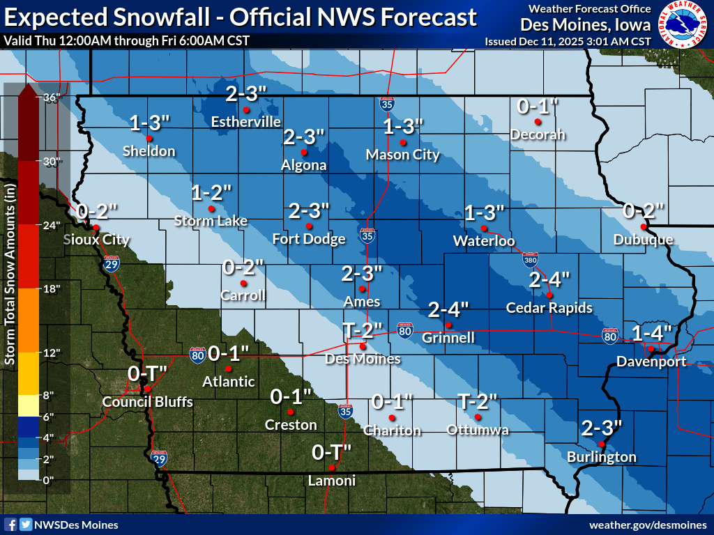
Snowfall
Most regions can expect 1 to 4 inches of snow, though areas in eastern Iowa may see isolated totals up to 5 inches, especially where snowfall remains steady during the evening and early overnight.
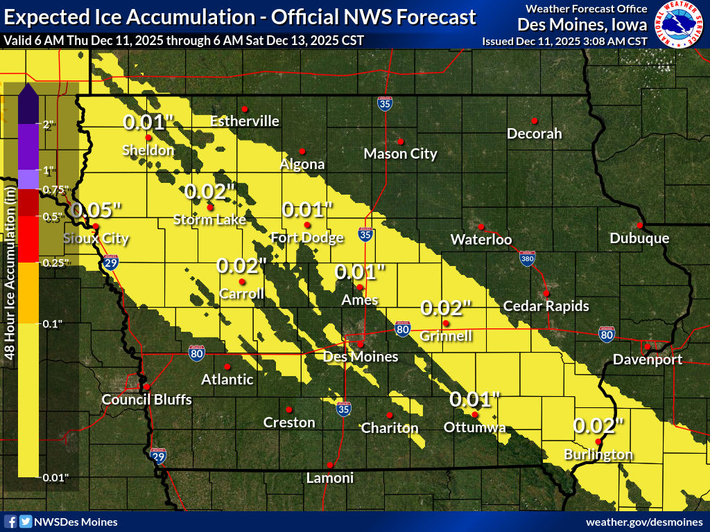
Ice Accumulation
Light icing is possible across northern and western Iowa, with a light glaze up to one-tenth of an inch. Even minor ice accumulation can create slick roadways and hazardous driving conditions.
Sleet
Brief sleet is possible, particularly early in northwest Iowa where colder air meets the initial surge of moisture. Sleet may mix in at times farther south as well, adding to the variability in road conditions.

Areas Impacted
The Winter Weather Advisory covers a wide section of Iowa, including:
- Northwest & Northern Iowa: Spirit Lake, Estherville, Osceola County, Dickinson County
- Central Iowa: Ames, Fort Dodge, Webster City, Iowa Falls
- Eastern Iowa: Waterloo, Cedar Rapids, Iowa City, Davenport, Muscatine, Clinton
- Southeast Iowa: Burlington, Mount Pleasant, Washington
Travel Impacts
Road conditions are expected to deteriorate through the afternoon and evening due to the combination of snow and freezing rain. Key concerns include:
- Slippery roads and reduced traction, especially on untreated surfaces
- Hazardous bridges and overpasses, which typically ice first
- Changing precipitation types, making it difficult for road crews to keep up
- Evening commute disruptions, particularly in central and eastern Iowa where timing aligns with peak travel hours
Travelers should allow extra time, drive slowly, and stay alert for rapidly changing conditions. For the latest updates on road conditions, visit 511ia.org or be sure to download the Iowa 511 app.
These tools provide real-time traffic speeds, plow camera images, and road condition reports to help travelers navigate safely.
We will continue to monitor the system throughout the day and provide updates as new data becomes available. Stay safe, use caution on the roads, and keep checking back for the latest winter weather information.