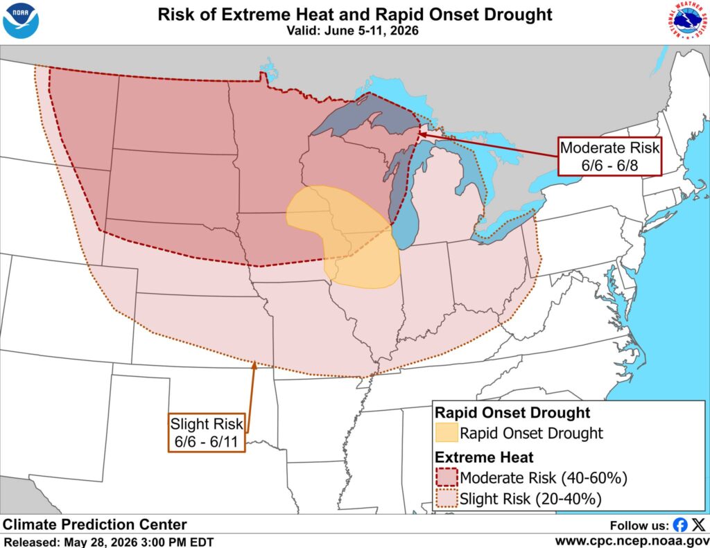
The Climate Prediction Center (CPC) is highlighting an increased risk of unusually warm weather across Iowa during the June 6 through June 11 timeframe, with much of the state included in an extreme heat outlook.
According to the latest 8-to-14 Day Hazards Outlook, a moderate risk of extreme heat has been issued for areas generally along and north of Interstate 80, while a slight risk of extreme heat extends southward to the Iowa-Missouri border. A moderate risk means there is a 40% to 60% chance that temperatures could reach levels considered unusually warm for early June.
What’s Driving the Warm-Up?
Forecast models continue to show a large area of high pressure building across the central United States during the second week of June. This weather pattern is expected to strengthen over the Plains and Upper Midwest, creating favorable conditions for a stretch of warmer-than-normal temperatures.
When strong high pressure settles overhead, it often leads to increased sunshine, fewer weather systems, and a reduced chance for widespread rainfall. Forecasters have noted growing confidence in this pattern as multiple weather models continue to show a stronger ridge developing across the central part of the country.
How Hot Could It Get?
While it is too early to determine exact temperatures, the overall pattern supports a period of above-normal warmth across Iowa. Typical highs for early June across Iowa are generally in the upper 70s to low 80s, and temperatures during this period could trend noticeably above those seasonal averages.
In addition, southerly winds may transport higher levels of moisture into the region, resulting in more humid conditions.
The combination of warmer temperatures and increasing humidity could make outdoor activities more uncomfortable, especially during the afternoon and evening hours.
For many Iowans, this could be the first prolonged stretch of summer-like heat this year.
Rapid-Onset Drought Risk Expands Into Parts of Iowa
The Climate Prediction Center is highlighting a possible rapid-onset drought risk across portions of northeast and eastern Iowa, along with parts of the Upper Mississippi Valley and Great Lakes region.
After a wet spring, rainfall has become more limited across portions of the Midwest in recent weeks. With warmer temperatures expected and rainfall remaining below average, some areas could begin drying out more quickly as we move into June.
Rapid-onset drought, sometimes called a “flash drought,” can develop in just a few weeks when hot temperatures, limited rainfall, and dry soils combine to quickly remove moisture from the ground.
The Climate Prediction Center only issues a rapid-onset drought outlook when several warning signs begin showing up at the same time. These include soils already starting to dry out, temperatures running above normal, little rainfall in the forecast, and signs that warm and dry weather could continue for another week or two.
When these conditions come together, forecasters become concerned that drought conditions could worsen rapidly over the next month. That’s why parts of Iowa have been included in the latest outlook.
This hazard outlook is relatively new. The Climate Prediction Center officially introduced the Rapid-Onset Drought Risk designation in May 2024 to better identify areas where drought conditions could develop and intensify quickly over a short period of time.
It’s important to note that this outlook does not mean a drought is already occurring. Instead, it means conditions are becoming favorable for one to develop if the expected pattern of warm and dry weather continues.
Forecasters will continue to monitor rainfall, temperatures, and soil moisture levels in the coming weeks to determine whether drought conditions begin to take hold across the region.
What This Means for Iowa
While forecast details will continue to be refined in the days ahead, confidence is increasing that Iowa will experience a stretch of warmer-than-normal weather during the second week of June.
Residents should be prepared for:
- Above-normal temperatures across much of the state, compared to typical early June highs in the upper 70s to low 80s
- Increasing humidity levels
- A lower chance of widespread rainfall
- Growing concerns about drying soils in parts of eastern and northeastern Iowa
The Iowa Storm Chasing Network weather team will continue monitoring forecast trends and provide updates as we get closer to the potential warm spell.
Be sure to check IowaWeather.com and keep the ISCN Weather App installed for the latest forecasts and weather updates.