Iowa Severe Weather Update: Damaging Winds, Large Hail, and a Few Tornadoes Possible Today Across Parts of Iowa
Published: Monday, July 20, 2026
A potentially active severe weather day is expected across Iowa as a strong cold front sweeps southeast across the state later today and tonight. Forecast confidence has continued to increase over the past 24 hours, and while some questions remain regarding the exact placement of the strongest storms, the overall forecast remains on track.
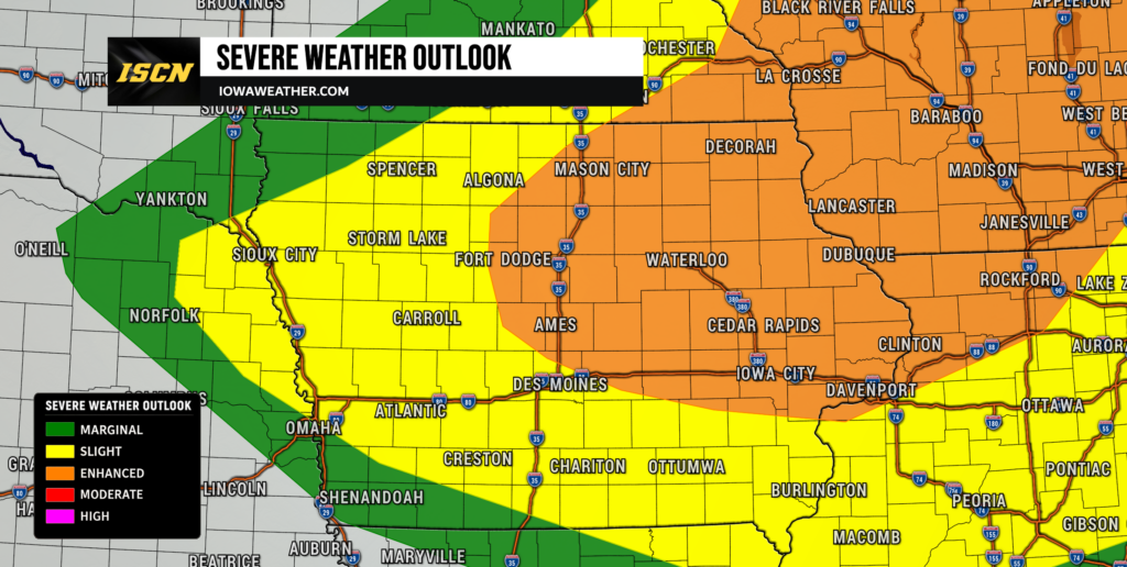
The Storm Prediction Center continues to highlight northeast Iowa in an Enhanced Risk (Level 3 of 5) for severe thunderstorms, with much of the remainder of the state under a Slight Risk (Level 2 of 5).
Morning Storms Are Not the Main Event
A cluster of thunderstorms moved through portions of northern Iowa early this morning, producing locally heavy rain, lightning, and a few gusty winds. While these storms have weakened considerably, they may still influence where the most unstable air develops later today.
One of the biggest forecast questions this morning is how quickly clouds and any lingering showers move out of the area. The faster skies clear, the more time the atmosphere will have to recover and become extremely unstable during the afternoon.
Current forecast guidance suggests that enough sunshine and warm, humid air will return across much of Iowa to support another round of much stronger thunderstorms later today.
Hot and Humid Conditions Will Fuel Storm Development
Before storms arrive, Iowa will experience another very warm and humid day.
Afternoon temperatures climbing into the upper 80s and lower 90s, combined with dew points in the lower 70s, will push heat index values into the 100 to 105 degree range across much of the state. Heat Advisories remain in effect for portions of Iowa.
This hot, moisture-rich environment will provide plenty of energy for thunderstorms once the approaching cold front reaches northern Iowa later this afternoon.
Forecast models continue to indicate an extremely unstable atmosphere capable of producing explosive thunderstorm development.
Timing: When Will Storms Arrive?
The first severe storms are expected to develop during the mid to late afternoon across northern Iowa as the cold front moves into the state.
Initially, storms may remain isolated, allowing individual thunderstorms to strengthen into supercells capable of producing all types of severe weather.
As the evening progresses, these storms are expected to merge into clusters or bowing line segments while moving southeast across central and eventually southern Iowa.
Although exact timing will vary depending on your location, the greatest threat for severe weather appears to be:
- Northern Iowa: 3 PM – 7 PM
- Central Iowa: 5 PM – 10 PM
- Southern Iowa: 7 PM – Midnight
These times may shift slightly depending on how quickly storms develop.
Primary Threat: Damaging Winds
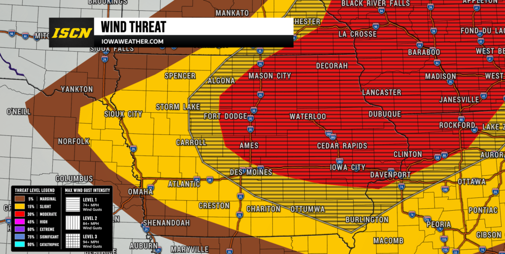
The greatest concern with today’s storms continues to be damaging straight-line winds.
Once storms organize into larger clusters or lines, widespread wind gusts between 60 and 75 mph will be possible. Isolated higher wind gusts cannot be ruled out where storms become especially intense.
These winds could:
- Down trees
- Damage roofs and siding
- Produce scattered power outages
- Make travel hazardous
Residents should be prepared for rapidly changing conditions this evening.
Large Hail Also Likely
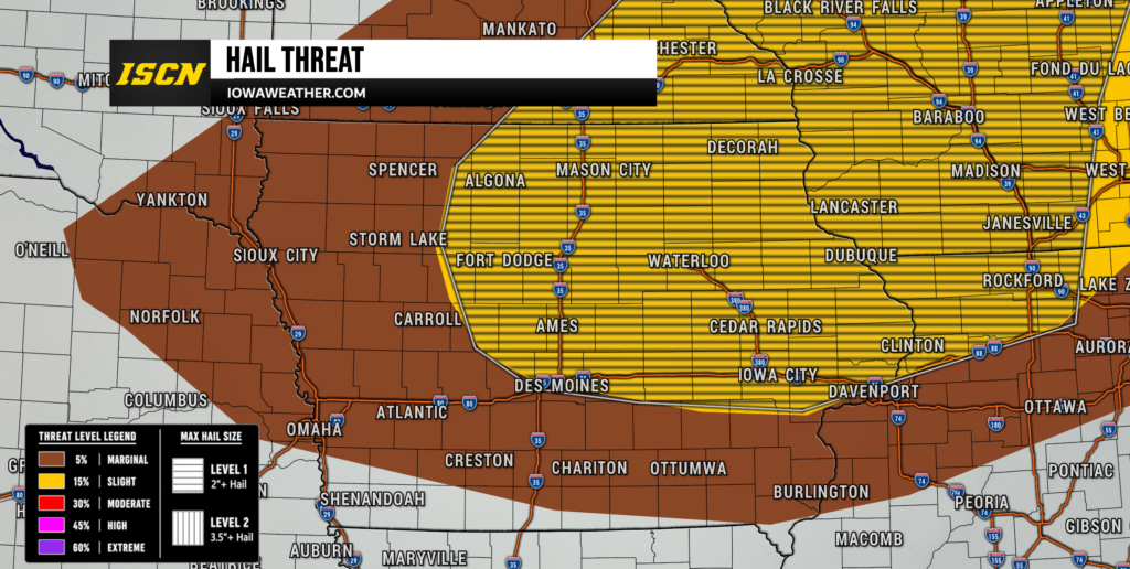
Large hail remains another significant concern.
Any storms that remain isolated during the initial development phase will have the greatest opportunity to produce hail larger than golf balls.
Once storms merge into lines, the hail threat will gradually decrease while damaging winds become the dominant hazard.
Tornado Threat Highest Across Northeast Iowa
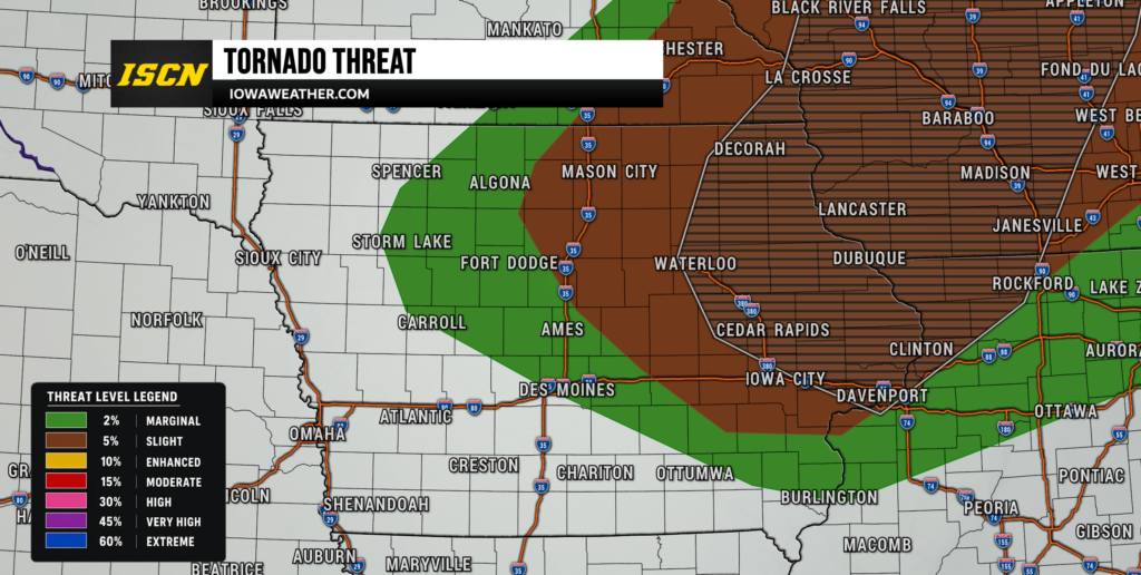
Although today’s tornado threat is lower than the damaging wind threat, it should not be ignored.
The greatest chance for tornado development remains across northeast Iowa, where low-level wind shear will be strongest this afternoon and evening.
If isolated supercells can develop before storms merge together, a few tornadoes will be possible, and one or two could become stronger than average if atmospheric conditions evolve favorably.
Farther south and west, the tornado threat decreases as storms become more linear, although brief spin-up tornadoes cannot be ruled out.
Heavy Rainfall Expected, But Flooding Concerns Remain Limited
Thunderstorms today will contain very high moisture levels and will be capable of producing torrential rainfall in a short amount of time.
Rainfall rates could briefly exceed one inch per hour in the strongest storms.
Fortunately, storms are expected to move fairly quickly, reducing the overall flooding risk. However, localized street flooding and ponding of water on roads will still be possible during heavier downpours.
Forecast Confidence
Overall confidence continues to increase that severe thunderstorms will develop today.
The primary uncertainty involves exactly where storms first form and how quickly they organize.
If morning clouds linger longer than expected, severe weather may become more localized. However, if skies clear quickly and the atmosphere fully recovers, today’s severe weather threat could become more widespread.
Either way, everyone across Iowa should closely monitor forecasts throughout the afternoon.
Stay Weather Aware Today
Now is the time to prepare before storms develop.
- Review your severe weather safety plan.
- Make sure you have multiple ways to receive warnings.
- Charge your mobile devices before storms arrive.
- Be ready to move indoors quickly if Severe Thunderstorm or Tornado Warnings are issued.
The ISCN team will be closely monitoring conditions throughout the day and will provide live updates, radar analysis, storm reports, and live video coverage as storms develop.
Be sure to download the FREE ISCN Weather App for live interactive radar, real-time warnings, storm reports, forecast updates, and live severe weather coverage throughout today’s event.