What Is a “Ring of Fire” Weather Pattern? Why It Often Brings Iowa Days of Storms and Dangerous Heat
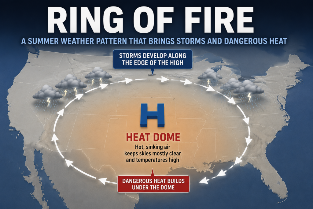
During the summer months, you may hear meteorologists talk about a “Ring of Fire” weather pattern setting up across the Midwest. Despite its intimidating name, it has nothing to do with volcanoes or wildfires. Instead, it’s a common summertime weather pattern that can bring repeated rounds of thunderstorms, damaging winds, torrential rainfall, and dangerous heat to parts of the United States—including Iowa.
Understanding what the Ring of Fire is can help explain why some stretches of summer feature multiple days of severe weather while other areas remain locked in intense heat.
What Is a Ring of Fire Weather Pattern?
A Ring of Fire develops when a large dome of high pressure, often called a heat dome, settles over the southern or central United States. Beneath this dome, sinking air suppresses cloud development, allowing temperatures to climb into the 90s or even above 100 degrees. While conditions under the center of the high pressure remain hot and relatively quiet, the atmosphere becomes much more active around its outer edge.
Along that edge, warm, moisture-rich air flowing north from the Gulf interacts with cooler air and stronger winds in the upper atmosphere. These ingredients create an environment where thunderstorms can repeatedly develop and travel around the perimeter of the heat dome. Meteorologists refer to this storm corridor as the “Ring of Fire.”
Why Does Iowa Often End Up in the Ring?
Iowa frequently sits along the northern edge of a summertime heat dome, placing the state in a prime location for repeated thunderstorm development. Instead of seeing one isolated severe weather event, Iowa can experience several rounds of storms over the course of multiple days. One cluster of storms may move through overnight, while another develops the following evening as the atmosphere reloads with heat and humidity.
This setup is especially common during July and August when warm temperatures and abundant moisture provide plenty of fuel for thunderstorms.
What Weather Does the Ring of Fire Produce?
One of the defining characteristics of a Ring of Fire pattern is its ability to produce repeated episodes of active weather. Thunderstorms often organize into large complexes capable of traveling hundreds of miles while producing widespread damaging straight-line winds. Some of the Midwest’s most significant derecho events have developed during Ring of Fire patterns.
These storms are also capable of producing large hail, torrential rainfall, flash flooding, frequent lightning, and occasionally tornadoes. Because multiple rounds of storms can pass over the same area, rainfall totals can add up quickly, increasing the risk of flooding in low-lying areas and along rivers and streams.
Why Are Ring of Fire Forecasts So Difficult?
Even when meteorologists recognize a Ring of Fire pattern several days in advance, predicting exactly where thunderstorms will develop remains one of the biggest forecasting challenges.
Small changes in the position of the heat dome, the location of a frontal boundary, or leftover outflow boundaries from previous storms can dramatically shift where thunderstorms form. A storm track that appears likely one day may shift 50 to 100 miles by the next forecast update. This is why forecasts are often refined several times a day whenever a Ring of Fire pattern is in place.
The Hidden Danger: Heat Is America’s Deadliest Weather Hazard
While severe thunderstorms often receive the most attention, the dangerous heat associated with a Ring of Fire pattern is frequently the greatest threat to public safety. In fact, heat is the number one weather-related killer in the United States, claiming more lives each year than tornadoes, hurricanes, floods, or lightning.
Extreme heat places tremendous stress on the human body, especially when high humidity limits the body’s ability to cool itself through sweating. Several consecutive days of hot temperatures, combined with warm overnight lows that offer little relief, can significantly increase the risk of heat-related illnesses.
Young children, older adults, people with chronic medical conditions, outdoor workers, and anyone without reliable air conditioning face the greatest risk during prolonged heat waves. Heat exhaustion can develop quickly and may include symptoms such as heavy sweating, dizziness, headaches, nausea, muscle cramps, and weakness. If someone becomes confused, stops sweating, or loses consciousness, they may be suffering from heat stroke, which is a life-threatening medical emergency that requires immediate medical attention.
How to Stay Safe During a Ring of Fire Pattern
When a Ring of Fire pattern develops, it’s important to prepare for both severe weather and dangerous heat. Stay hydrated by drinking water regularly throughout the day, even if you don’t feel thirsty. Limit strenuous outdoor activities during the hottest part of the afternoon, wear lightweight clothing, and seek air-conditioned spaces whenever possible. It’s also important to check on elderly family members and neighbors, and never leave children or pets inside parked vehicles, where temperatures can become deadly within minutes.
At the same time, continue monitoring weather forecasts each day. Because thunderstorms may develop quickly and often occur after sunset or overnight, having multiple ways to receive weather warnings—including NOAA Weather Radio, smartphone alerts, and trusted local weather sources—can provide valuable extra time to take shelter if severe weather develops.
Why Meteorologists Watch the Ring of Fire Closely
The Ring of Fire is one of the most closely monitored summertime weather patterns because it can produce several consecutive days of impactful weather. Instead of focusing on one isolated storm, forecasters are often tracking an entire pattern that may continue generating thunderstorms for nearly a week.
For Iowa residents, understanding the Ring of Fire helps explain why forecasts sometimes call for repeated severe weather chances, overnight storms, and dangerous heat all at the same time. Staying aware of the forecast each day and understanding how this weather pattern works can help you better prepare for whatever the atmosphere has in store.