Much of Iowa is entering a wetter stretch of weather as a slow-moving cold front settles across the state. We do not expect widespread severe weather, but periods of showers and thunderstorms will bring locally heavy rainfall through Wednesday. Storms repeatedly moving over the same locations cause localized flash flooding, especially in cities and areas that recently received heavier rainfall.
The overall pattern favors beneficial rainfall for many communities, particularly across central and southern Iowa where drought conditions and dry soils have persisted in many locations. However, some thunderstorms will be capable of producing intense rainfall in a short amount of time. After this system exits later Wednesday into Thursday, Iowa will return to quieter weather before temperatures climb back into the upper 80s and lower 90s heading into the weekend.
Heavy Rain Becomes Iowa’s Biggest Weather Concern
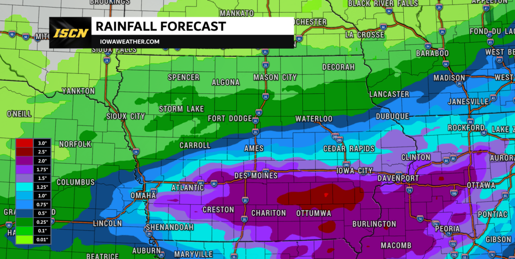
Periods of showers and thunderstorms will continue to develop across Iowa through Wednesday as a cold front slowly pushes south before stalling across the region. This setup allows several rounds of rain to move across many of the same locations instead of quickly sweeping east. Atmospheric moisture remains unusually high for early August, meaning any thunderstorm will be capable of producing very heavy rainfall in a short period of time. Most locations can expect between 1 and 3 inches of rain, although isolated areas where storms repeatedly track over the same location could receive considerably more. The highest confidence for heavier rainfall extends across portions of central and southern Iowa, with the exact corridor depending on where the front ultimately stalls.
Localized Flash Flooding Is Possible, Especially in Cities
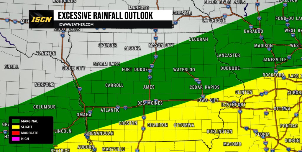
Although widespread flooding is not anticipated, localized flash flooding remains a concern through Wednesday. Much of rural Iowa has relatively dry soils and mature crops. These can absorb a significant amount of rainfall before flooding develops. Urban areas are more vulnerable because pavement and storm drainage systems cannot handle intense rainfall as efficiently. If thunderstorms repeatedly move across the same communities, water could quickly accumulate on streets, low-lying areas, and poor drainage locations. Anyone traveling during heavier downpours should never attempt to drive through flooded roadways, as water depths can change rapidly.
Thunderstorms Will Be Common, But Severe Weather Should Remain Limited
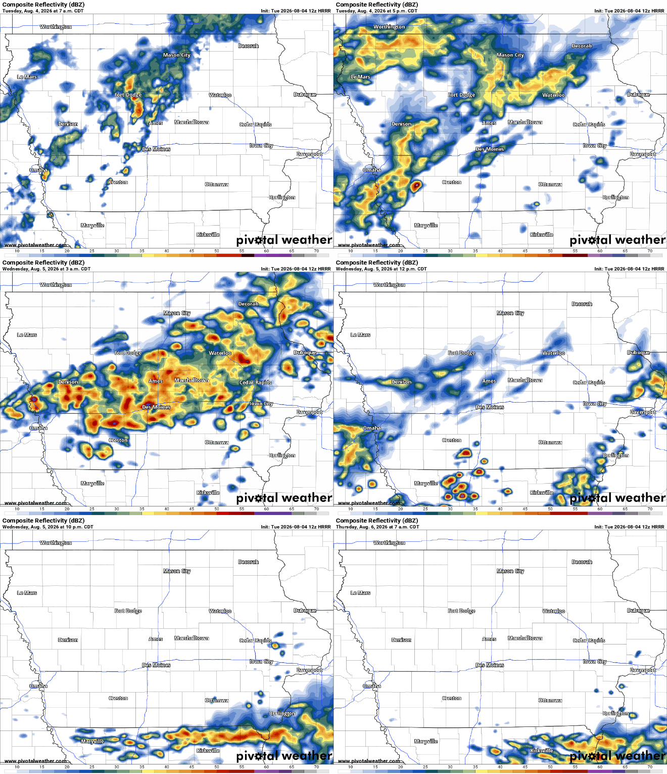
Thunderstorms will accompany the rain through Wednesday, but the overall severe weather threat remains relatively low. The atmosphere contains enough moisture to support widespread rain. Instability is fairly modest, and wind shear is only marginally supportive of organized severe storms. As a result, most thunderstorms will primarily produce heavy rain along with occasional lightning. An isolated storm could briefly bring gusty winds to 50 mph. Widespread damaging winds, large hail, and tornadoes are not expected.
Where the Heaviest Rain Is Most Likely
Current forecast guidance highlights the highest rainfall totals in central and southern Iowa. These totals are generally near and south of Highway 30. Some forecast models indicate localized rainfall totals exceeding 4 inches where thunderstorms repeatedly develop over the same area. Communities farther north will still receive beneficial rainfall, but overall totals should be lower and more scattered. There is still uncertainty about how far south the heaviest rain band will extend. Small shifts in the stalled front will influence where thunderstorms repeatedly form. Even with that uncertainty, confidence remains high that much of Iowa will receive measurable rain before the system departs.
Cooler Weather Midweek Before Summer Heat Returns
Clouds and periods of rain will keep temperatures below normal through Wednesday across much of Iowa. Afternoon highs will generally stay in the 70s to lower 80s. This will feel cooler than recent days despite the humidity. Once the storm system exits, sunshine will gradually return beginning Thursday. High pressure building into the Midwest will allow temperatures to steadily climb through the end of the workweek. By Saturday and Sunday, many Iowa communities will once again experience highs in the upper 80s to lower 90s with increasing humidity.
Looking Ahead
After showers gradually diminish Wednesday night into Thursday, Iowa is expected to enjoy several days of quieter weather. Forecast confidence is high that Thursday and Friday will be mostly dry for the majority of the state. A few isolated thunderstorms cannot be completely ruled out later in the weekend as weak disturbances move around a strengthening ridge, but confidence in their timing and placement remains fairly low this far out. Temperatures will continue trending warmer, and many locations could approach or exceed 90 degrees by the second half of the weekend. Iowa residents should enjoy the break from widespread rain while continuing to monitor later forecasts for any changes in weekend storm chances.
Stay with IowaWeather.com for the latest weather forecast updates as conditions continue to evolve across Iowa.