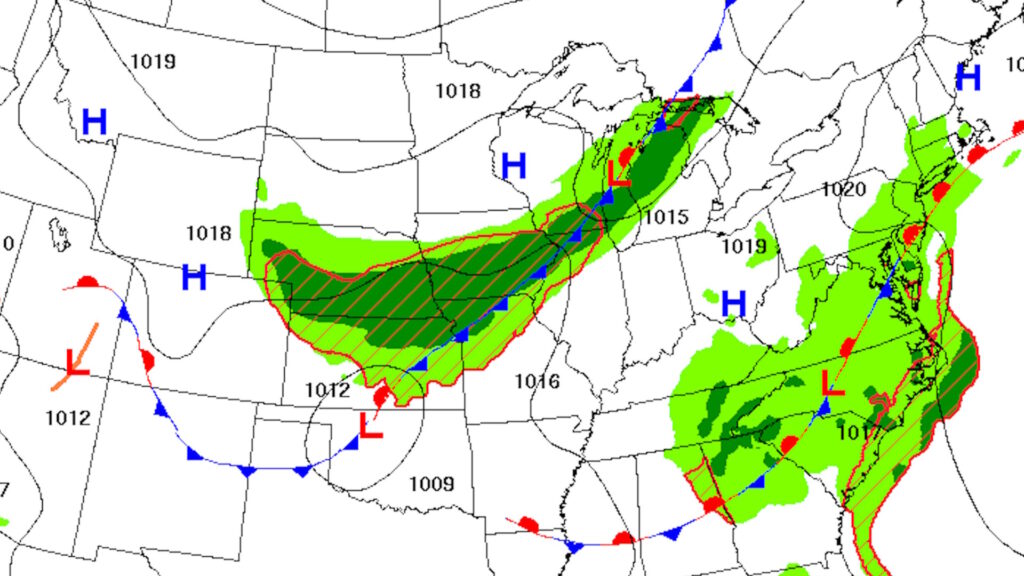
The quiet stretch of weather across Iowa is coming to an end. After another warm, mostly sunny day Monday, a slow-moving cold front will approach from the northwest and bring increasing chances for showers and thunderstorms beginning late Monday night in northwest Iowa before expanding across much of the state Tuesday into Wednesday. While severe weather appears to be limited for most areas, the potential for repeated rounds of rain is becoming the primary concern.
Many communities could receive a much-needed soaking after recent dry conditions, especially across western Iowa where soil moisture remains well below average. However, if thunderstorms repeatedly move over the same locations, localized flooding could develop, particularly in urban areas where heavy rainfall can quickly overwhelm drainage systems. Confidence is high that rainfall will become more widespread during the middle of the week, while confidence is lower regarding exactly where the heaviest rainfall axis ultimately develops.
Dry, Warm Weather Continues Through Monday
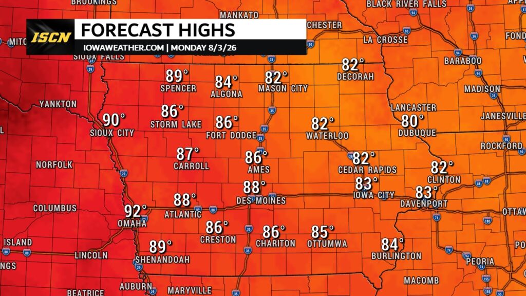
Monday brings another pleasant summer day across Iowa with abundant sunshine, seasonably warm temperatures, and only a light veil of wildfire smoke high overhead creating a slightly hazy appearance, especially around sunrise and sunset. Morning patchy fog quickly dissipates after sunrise before southerly winds increase during the afternoon. High temperatures will range from the lower 80s in eastern Iowa to the upper 80s and near 90 degrees across western portions of the state. While breezy conditions develop in northern and western Iowa, the weather remains ideal for outdoor plans, agricultural work, and travel. Confidence in today’s forecast is very high as strong upper-level ridging continues to dominate the central United States.
Storm Chances Increase Tuesday as Cold Front Arrives
The weather pattern begins changing late Monday night as a cold front gradually pushes into northwest Iowa. A few showers or thunderstorms may develop near the Minnesota border before sunrise Tuesday, but much of the state will remain dry through the morning hours. During Tuesday afternoon, thunderstorms become more numerous across northern and western Iowa before gradually spreading southeast Tuesday night into central and southern Iowa. Eastern and southeastern Iowa may stay largely dry until later Tuesday or Tuesday evening. Although a few stronger storms cannot be ruled out near the front, widespread severe weather is not expected because the best instability and strongest wind shear remain somewhat out of phase.
Heavy Rain Could Become the Biggest Concern
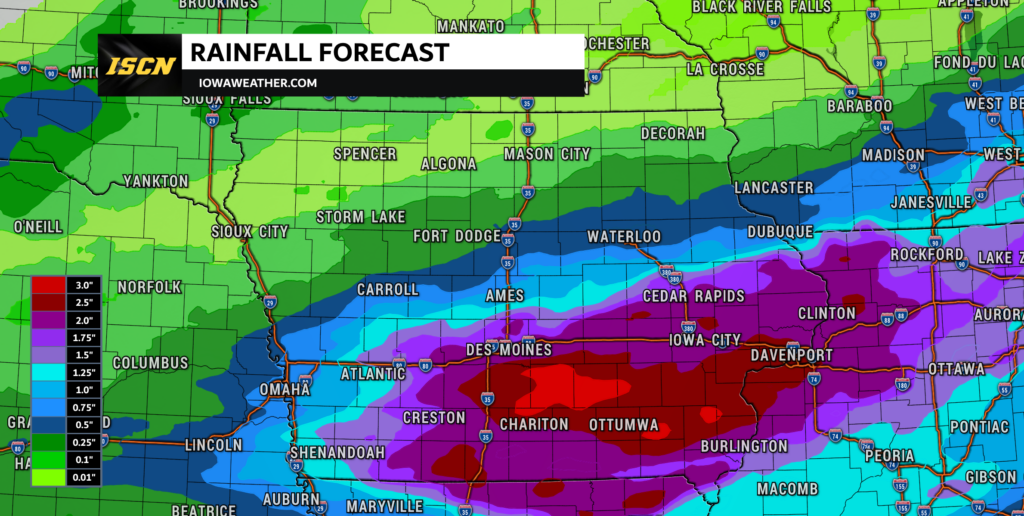
The greatest weather threat this week appears to be heavy rainfall instead of widespread severe thunderstorms. Atmospheric moisture will increase significantly ahead of the cold front, providing plenty of fuel for efficient rainfall production. Forecast guidance indicates some thunderstorms may repeatedly move over the same areas, a process known as training, which can quickly lead to rainfall totals exceeding two inches with isolated locations potentially receiving much higher amounts if storms repeatedly redevelop.
Western Iowa’s relatively dry soils should help absorb a good portion of the rainfall, while eastern Iowa has wetter ground from recent rainfall and could become more susceptible to localized flooding. Urban areas remain the most vulnerable because rainfall rates exceeding two inches per hour can overwhelm storm drains and create flash flooding in low-lying locations. Residents should continue monitoring the latest weather forecast, weather radar, and local weather updates as confidence increases on where the heaviest rainfall will occur.
Cooler Midweek Before Summer Heat Builds Again
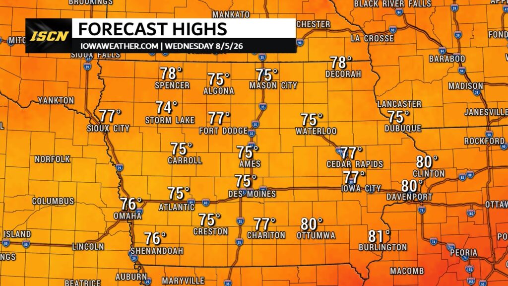
Behind the cold front, temperatures will cool back into the 70s across much of Iowa on Wednesday while clouds and scattered showers linger. Rain chances gradually decrease from northwest to southeast later Wednesday into Thursday as drier air slowly moves into the region. By Friday and into the weekend, warmer air begins returning with highs climbing back into the upper 80s and lower 90s in many locations. Humidity is also expected to increase, signaling another more typical August pattern across the Midwest. Longer-range forecast guidance suggests hotter conditions could continue expanding eastward into next week, although confidence naturally decreases later in the forecast period.
Looking Ahead
Iowa’s weather pattern is transitioning from quiet and comfortable to much more active over the next several days. Monday offers one final dry day for most locations before showers and thunderstorms gradually spread into the state beginning late Monday night and continuing through Wednesday. The highest confidence is centered on beneficial rainfall for many areas, while the greatest uncertainty involves exactly where the heaviest bands of rain set up and whether localized flooding develops. Severe weather appears to be a secondary concern at this time, with heavy rainfall expected to have the greatest impact. Anyone with outdoor plans during the middle of the week should stay informed and monitor updated weather today, weather tomorrow, and doppler radar information as the forecast becomes more refined.
Stay with IowaWeather.com for the latest forecast updates, interactive weather radar, severe weather coverage, and in-depth analysis as this midweek storm system approaches.
Could you tell me what Albia weather looks like the reason is I have meds to give if it’s going to rain or storms