Iowa Weather: More Storms Saturday, Dry Sunday Before Tuesday Severe Threat
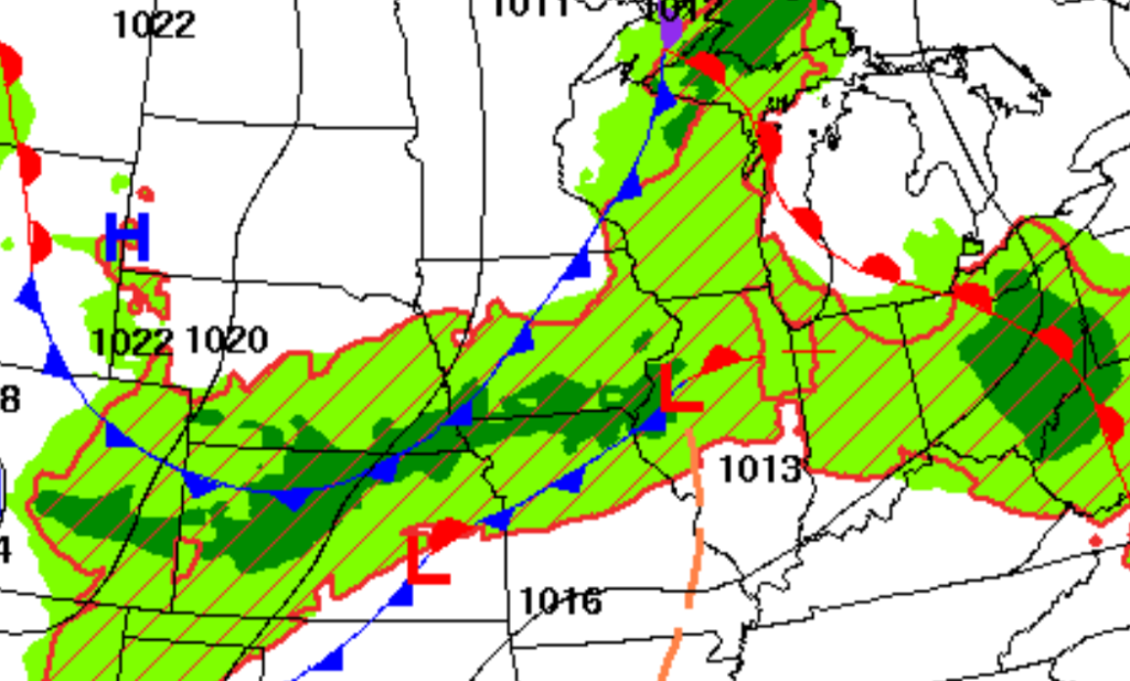
Saturday begins with another round of showers and thunderstorms winding down across southern and eastern Iowa after producing locally heavy rain overnight. The heaviest activity early this morning is concentrated mainly across southern and southeast Iowa, where a very moisture-rich atmosphere has supported efficient rainfall and repeated downpours. Most of this morning’s rain will gradually shift east and weaken, allowing much of the state to see a break by late morning or midday. However, the weather today will not be completely dry, as another boundary moving through Iowa may trigger scattered thunderstorms later this afternoon and evening.
The encouraging part of the forecast is that the pattern finally begins to change this weekend. A cold front will move through Iowa tonight, followed by noticeably drier air and high pressure Sunday into Monday. That should give much of the state its first widespread break from the persistent rain and thunderstorms of the past several days. The quieter weather will not last all week, though, as another stronger system could bring organized thunderstorms and a renewed severe weather threat to Iowa Tuesday afternoon into Tuesday night.
Thunderstorms Gradually Fade This Morning, but More Are Possible Later
For anyone wondering whether it will rain today, the answer depends heavily on location and time of day. Thunderstorms affecting southern and eastern Iowa early Saturday morning will continue shifting east while gradually weakening, with most areas trending considerably quieter by late morning or midday. Low clouds, areas of fog and lingering haze may be slower to clear, especially in parts of western and central Iowa, and that could hold temperatures down somewhat during the afternoon. Farther north and northwest, scattered showers and thunderstorms may redevelop as another disturbance and cold front move through the region.
Additional thunderstorms are also possible across central and eastern Iowa later this afternoon and into the evening as the front continues east. Coverage should be more scattered than the widespread overnight activity, so not everyone will receive another round of rain. The atmosphere will remain very humid, meaning any thunderstorm that develops could produce a quick downpour and frequent lightning. Most storms should continue moving rather than repeatedly tracking over the same locations, which lowers the widespread flooding concern compared with recent days. Iowa residents with outdoor plans should still keep an eye on local weather radar, particularly from mid-afternoon through the evening.
Severe Weather Threat Is Low Today
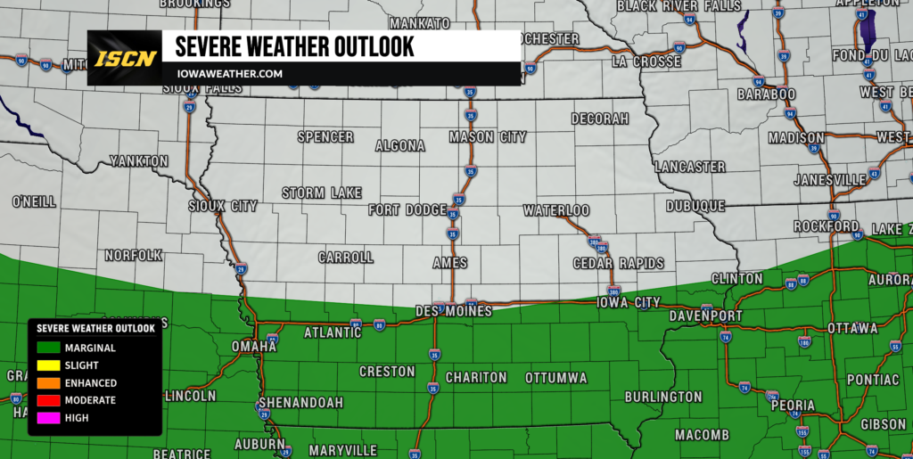
The overall severe weather risk across Iowa today is relatively low, although an isolated stronger storm cannot be completely ruled out. Wind shear, which describes how wind speed and direction change with height, is generally too weak to support widespread organized severe thunderstorms. Instability will also depend on how quickly morning clouds and low stratus can clear, adding another limiting factor to the threat. If a stronger storm does form, locally gusty winds would be the primary concern rather than a widespread damaging wind or tornado event.
The Storm Prediction Center’s main organized severe weather areas today are outside Iowa, while portions of the central Plains and Missouri Valley could still see isolated strong thunderstorms tonight. Across Iowa, storms are expected to be mostly elevated or clustered with only marginal organization. A few storms could still produce brief strong wind gusts, especially where heavier rain helps drag stronger winds toward the surface. Confidence is fairly high that heavy rainfall and lightning will be more common concerns than severe weather through tonight.
Sunday Finally Brings a Much-Needed Break
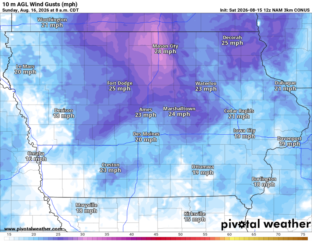
Sunday is shaping up to be the best weather day Iowa has experienced in several days. The cold front responsible for Saturday’s scattered storms will move east overnight, allowing drier Canadian air to spread south across the state. Most of Iowa should remain dry Sunday with a mix of sunshine and clouds, while humidity levels begin to fall. Afternoon temperatures will generally be seasonable to slightly below normal, with many locations reaching the upper 70s to lower 80s.
Northwest winds may become a little breezy across northeast Iowa Sunday afternoon, with occasional gusts around 20 to 25 mph possible. Otherwise, outdoor plans should be in good shape across nearly the entire state. The drier atmosphere will also make temperatures feel more comfortable than they have during the recent stretch of humid and stormy weather. A few areas of patchy fog cannot be ruled out early Sunday morning, particularly in low-lying locations, but widespread dense fog appears less likely than Saturday morning. Confidence is high in a substantially quieter and drier Sunday forecast.
Dry and Pleasant Weather Continues Monday
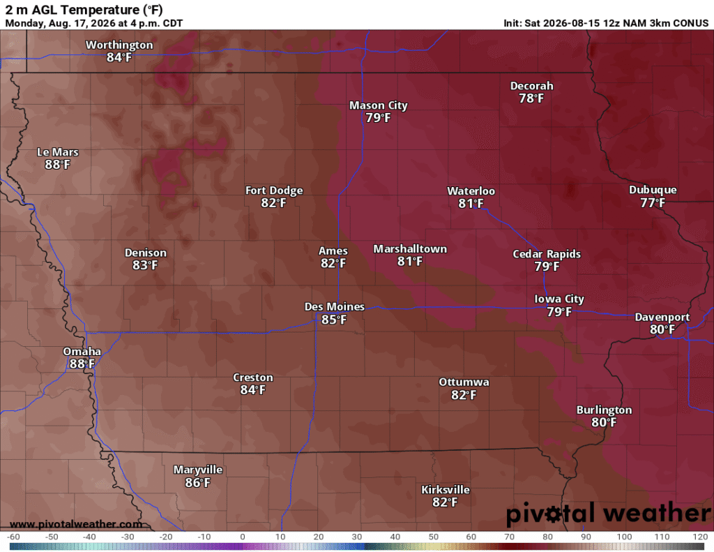
The break in the active weather pattern should continue through most of Monday as high pressure remains in control. Iowa’s local weather forecast calls for mainly dry conditions, seasonable temperatures and considerably lower rain chances during the daytime hours. Highs will generally reach the upper 70s to middle 80s, with the warmest readings likely in western and southern portions of the state. Humidity will remain manageable, making Monday another favorable day for outdoor work, travel and events.
Clouds may begin increasing later Monday as the next weather system approaches from the northwest. A few showers or thunderstorms could approach northwest Iowa Monday night, but the more substantial thunderstorm potential should hold off until Tuesday. The exact arrival time of that next system remains somewhat uncertain because forecast models differ on how quickly the upper-level disturbance and surface front will move southeast. Even with that timing uncertainty, confidence is relatively high that Monday daytime will remain mostly dry across Iowa. The quieter Sunday and Monday period will be important after multiple rounds of rain have affected the state during the past week.
Tuesday Brings a Renewed Strong to Severe Storm Threat
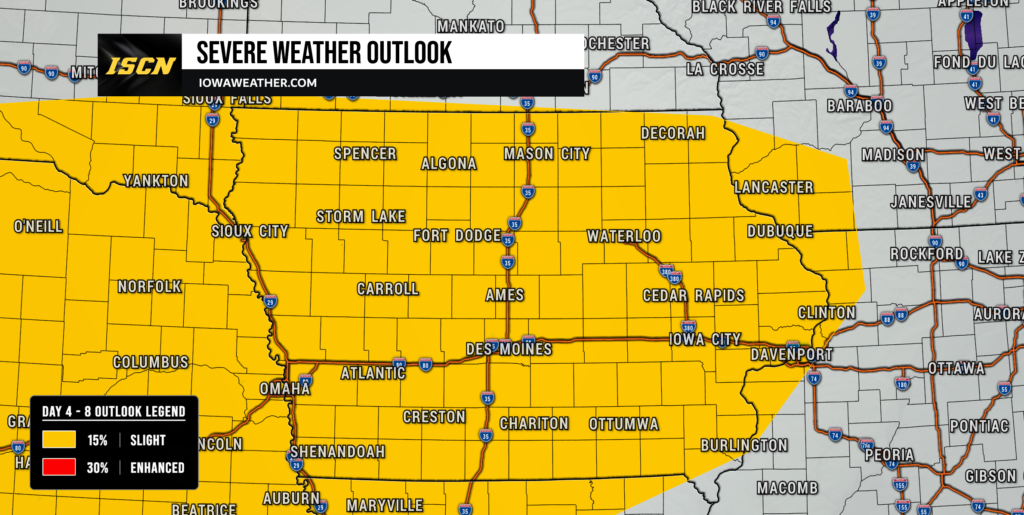
Tuesday is becoming the next day to watch closely for severe weather in Iowa. A stronger upper-level disturbance will move through the northern Plains and Midwest while a cold front pushes south and southeast toward the state. Warm, moisture-rich air is expected to return ahead of that boundary, allowing instability to build during the afternoon. At the same time, stronger winds several thousand feet above the ground should create substantially more wind shear than Iowa will have today.
The Storm Prediction Center is already highlighting portions of Nebraska, Iowa and surrounding areas for the potential for organized severe thunderstorms Tuesday. Forecast wind profiles could support supercells initially, which would bring a risk of large hail before storms potentially merge into a larger complex or line. If storms grow into a line during the evening, the primary threat could transition toward damaging straight-line winds as thunderstorms move southeast across the region. Heavy rainfall will also be possible because deep moisture is expected to return ahead of the front. Confidence in a severe weather threat is increasing, but the exact corridor of greatest risk and storm timing will depend on how much instability develops after any morning clouds or thunderstorms.
Tuesday Storm Timing Still Needs Refinement
Current forecast trends favor the greatest thunderstorm potential beginning sometime Tuesday afternoon across portions of western or northern Iowa before spreading farther southeast Tuesday evening and overnight. Northwest Iowa may see storms arrive sooner as the cold front approaches from the Dakotas and Nebraska, while central and eastern Iowa could have a later evening or nighttime threat. Some guidance suggests storms could organize into a larger thunderstorm complex similar to several systems that have crossed the region recently. Unlike some of the slow-moving storms this week, Tuesday’s system appears more progressive and should continue moving southeast rather than remaining over the same areas for an extended period.
One important uncertainty involves possible morning thunderstorms or leftover cloud cover Tuesday. If widespread clouds persist into the afternoon, instability could be reduced and the severe weather threat may be somewhat lower. If skies clear and temperatures rise efficiently, a much more unstable atmosphere could develop ahead of the front, increasing the potential for large hail and damaging winds. That difference will not become clear until shorter-range weather models and observational trends come into better agreement. Anyone with Tuesday afternoon or evening plans should continue checking the weather forecast as timing and risk areas become better defined.
Cooler and Quieter Weather Returns Later in the Week
Once Tuesday night’s system moves through, another cooler and drier air mass should spread into Iowa Wednesday and remain in place through much of the second half of the week. Thunderstorms may linger into early Wednesday in eastern Iowa depending on the speed of the front, but conditions should improve from west to east. High temperatures later in the week may fall back into the 70s across much of the state, especially Thursday and Friday. That would put temperatures below the hotter and more humid conditions Iowa experienced earlier this month.
There is still some disagreement among longer-range forecast guidance about whether small disturbances could produce isolated showers later in the week. At this point, the most likely outcome favors predominantly dry weather after the Tuesday night system exits. Northwest flow aloft should help keep the hottest air displaced south and west of Iowa while Canadian high pressure influences the region. Humidity should also decrease behind the front, providing another stretch of more comfortable weather. Confidence in the overall cooler pattern is relatively high, while confidence in individual small rain chances later in the week remains lower.
Stay with IowaWeather.com throughout the weekend and early next week for the latest Iowa weather updates, storm timing, radar information and severe weather forecast details as Tuesday’s system comes into better focus.