Quiet Monday Gives Way to Storms Tonight; Severe Weather and Heavy Rain Possible Tuesday
Iowa will get a welcome break from active weather for much of Monday before thunderstorms return late tonight and become a bigger concern Tuesday. High pressure moving across the state will provide mostly dry weather today, with comfortable August temperatures generally in the upper 70s and lower 80s. Humidity will remain noticeable, but conditions should feel considerably quieter than the stormy pattern Iowa has experienced recently. Anyone with outdoor plans during the daytime Monday should have few weather-related problems.
The pattern begins changing tonight as disturbances move southeast through the northwesterly flow over the Plains and Midwest. Thunderstorms developing to the northwest are expected to reach parts of Iowa overnight, followed by additional storm chances Tuesday morning and again later Tuesday. The exact evolution of those early storms will play a major role in determining how much severe weather develops Tuesday afternoon and evening. Damaging winds, large hail and locally heavy rain are the primary concerns, while an isolated tornado threat cannot be ruled out in areas where favorable boundaries develop.
Pleasant and Dry Weather Across Iowa Today
Monday’s weather will be unusually quiet compared with the active pattern of the past several days. High pressure moving from eastern Nebraska across Iowa will keep the state dry through the main daytime hours, with only limited cloud cover expected. Afternoon temperatures should generally reach the upper 70s to lower 80s across much of Iowa, which is seasonable to slightly comfortable for the middle of August. Winds will remain fairly light before gradually turning as the high moves east and moisture begins returning from the southwest. Dew points in the 60s mean the air will not feel especially dry, but the combination of mild temperatures and light winds should make for a pleasant day. For anyone searching the Iowa weather forecast before heading outside, Monday daytime offers the best opportunity for outdoor activities before thunderstorms return tonight.
Thunderstorms Return to Iowa Tonight
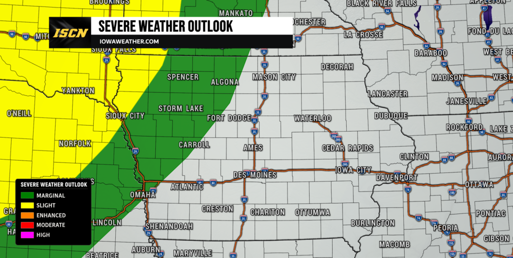
The first thunderstorms affecting Iowa are expected to arrive from the northwest and north later tonight. Storms should initially develop across portions of South Dakota, Minnesota and Nebraska before tracking southeast toward northern and western Iowa during the evening and overnight hours. One round moving out of Minnesota and eastern South Dakota may gradually weaken as it outruns the strongest surface instability and encounters somewhat drier air farther into Iowa. Even so, a damaging wind gust cannot be ruled out across northwest Iowa before those storms weaken. A second area of thunderstorms developing farther west over Nebraska and South Dakota may become more organized overnight and could reach Iowa late tonight into Tuesday morning. Because of these multiple possible rounds, residents in western and northern Iowa should check weather radar before bed and keep a way to receive any severe thunderstorm warning that may be issued overnight.
Timing remains somewhat uncertain because forecast models are still struggling with exactly where the strongest thunderstorms organize and how quickly they move southeast. Northern and northwest Iowa have the best chance of seeing storms first, potentially beginning during the late evening and continuing overnight. Additional storms could spread farther into central and western Iowa toward Tuesday morning, while eastern Iowa may remain dry for much of Monday night. The severe weather threat should generally decrease as individual storms move deeper into Iowa overnight, but the later cluster could maintain stronger winds longer if it becomes well organized. Thunderstorms will also be capable of producing locally heavy rain because moisture will increase quickly overnight. This early convection is important because it will help determine where boundaries settle and how unstable the atmosphere can become later Tuesday.
Severe Weather Threat Develops Tuesday
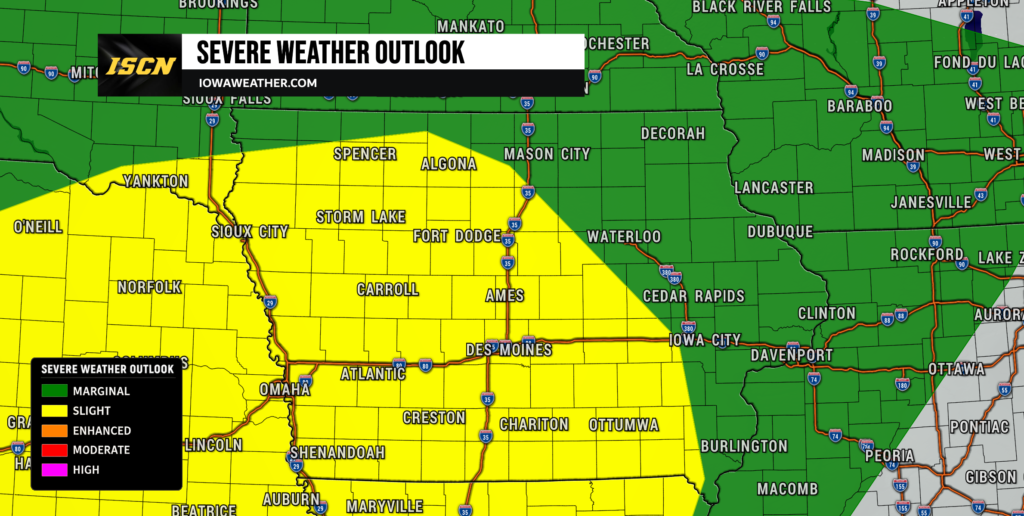
Tuesday carries the greater potential for strong to severe thunderstorms across portions of Iowa, but confidence in the exact placement and magnitude of the threat is lower than usual. A strengthening disturbance aloft will move across the region while a cold front pushes southeast and stronger northwest winds several thousand feet above the ground spread over the state. This combination can provide enough wind shear, or a change in wind speed and direction with height, to organize thunderstorms capable of producing severe weather. The Storm Prediction Center has placed portions of Iowa within a Slight Risk, Level 2 of 5, with surrounding areas included in a Marginal Risk, Level 1 of 5. Large hail and damaging wind gusts are expected to be the primary hazards where storms can become established Tuesday afternoon and evening. The greatest uncertainty is whether morning thunderstorms and lingering clouds will prevent the atmosphere from becoming sufficiently unstable for a more widespread afternoon severe weather event.
Where sunshine breaks through and stronger instability develops, storms could quickly intensify along the cold front or leftover outflow boundaries from earlier thunderstorms. Wind shear of roughly 30 to 50 knots across portions of the region would be sufficient for organized cells initially, including a few supercells, before storms potentially merge into clusters or a larger line. Large hail would be more likely with discrete storms early in their life cycle, while the damaging wind threat could increase if thunderstorms grow into a larger complex Tuesday evening. Eastern Iowa currently has a somewhat more conditional severe weather threat because showers or thunderstorms earlier in the day could reduce afternoon heating before the front arrives. Western and southwest Iowa may have a better opportunity to recover depending on where morning storms track and where the main surface boundary settles. Forecast confidence in thunderstorms occurring Tuesday is relatively high, but confidence in exactly where the strongest severe storms develop remains moderate to low.
Damaging Winds and Large Hail Are the Main Threats
Damaging winds appear to be the most widespread severe weather concern as storms organize Tuesday afternoon and evening. Strong winds several thousand feet above the ground could be transported toward the surface by thunderstorms, especially if individual cells merge into a line or larger thunderstorm complex. Some storms could initially produce large hail where instability and wind shear overlap most effectively, particularly across western Iowa and nearby portions of Nebraska. Hail size will depend heavily on whether thunderstorms remain separated long enough to develop stronger rotating updrafts before clustering together. The threat should gradually transition toward stronger wind gusts if storms organize into a larger complex during the evening or overnight hours. Anyone with outdoor equipment, vehicles or other property vulnerable to hail and wind should monitor the local weather closely Tuesday.
The severe threat may also shift substantially during the day as the Storm Prediction Center forecasters see what happens with Tuesday morning thunderstorms. Extensive clouds and rain-cooled air would limit instability and could reduce both hail and wind potential in parts of Iowa. On the other hand, several hours of sunshine behind the morning storms could allow temperatures and instability to recover quickly ahead of the approaching cold front. This type of setup can produce sharp differences in severe weather potential over relatively short distances. A county that remains cloudy much of the day could have considerably less severe weather than an area only 50 to 100 miles away that experiences stronger heating. Tuesday’s weather today and weather radar trends will therefore become especially important when determining where the afternoon threat ultimately focuses.
Heavy Rain and Localized Flash Flooding Are Also Concerns
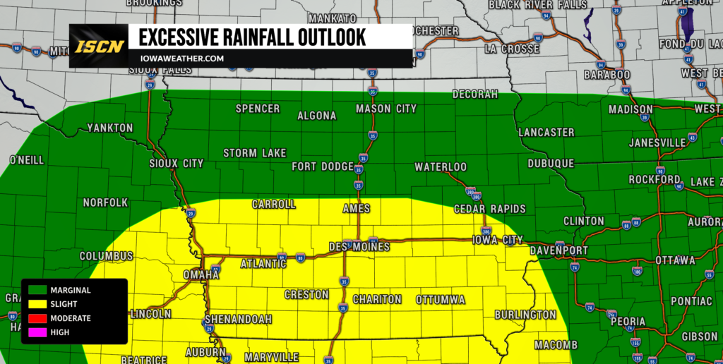
Heavy rainfall may become just as important as the severe weather threat Tuesday and Tuesday night, especially across southern and western portions of Iowa. Atmospheric moisture will increase substantially, with precipitable water values approaching 2 inches in parts of the state, meaning thunderstorms will have plenty of moisture available to produce intense rainfall rates. The Weather Prediction Center has outlined portions of the Midwest and Missouri Valley for a Slight Risk of excessive rainfall Tuesday into Wednesday. The most concerning corridor currently extends near the Iowa, Missouri, Nebraska and Kansas region, where repeated thunderstorms could track across some of the same locations. Local rainfall totals of 2 to 4 inches are possible within the most heavily affected corridors, although those amounts are not expected across all of Iowa. Exactly where the heaviest rain develops will depend on the position of the front, overnight storm tracks and any boundaries left behind by earlier convection.
Flooding concerns are elevated because some areas have already received considerable rainfall during the recent active weather pattern. Ground that is already wet cannot absorb rainfall as efficiently, making rapid runoff and localized flash flooding more likely beneath slow-moving or repeated thunderstorms. Urban areas, low-lying roads, creeks and poor-drainage locations would be most vulnerable if several inches of rain fall in a short period. The strongest signal for excessive rainfall is currently Tuesday evening into Tuesday night, when a strengthening low-level jet may continually transport moisture into the thunderstorm complex. There remains uncertainty over the exact placement of this heavy rain corridor, so not every location within the current risk area will receive flooding rainfall. Drivers should never attempt to cross a flooded roadway, especially at night when the depth and condition of the pavement can be impossible to judge.
Cooler Weather Arrives Behind the Storms
A cold front will gradually move through Iowa Tuesday night into Wednesday, bringing a cooler pattern for the middle and latter part of the week. Some showers and thunderstorms could linger across southern or eastern Iowa Wednesday morning as the front exits, but the severe weather threat should be much lower by that point. Afternoon highs Wednesday should generally fall into the 70s to lower 80s, with some locations running below normal for mid-August. Light northerly or northeasterly winds will gradually bring less humid air into portions of the state, although southern Iowa may take longer to notice a significant drop in moisture. Additional weak disturbances could produce isolated showers later in the week, but widespread rain and severe thunderstorms currently appear less likely after Wednesday. Overall, the Iowa weather forecast turns quieter and more comfortable once the Tuesday storm system clears the region.
The biggest improvement may arrive toward the end of the week and into the weekend as stronger high pressure potentially builds toward the Upper Midwest and Great Lakes. Eastern Iowa has a good chance of seeing temperatures mainly in the upper 70s late in the week with lower humidity than the state has experienced recently. Western Iowa may gradually warm back into the lower or middle 80s by Friday, but those temperatures would still be close to typical August levels. A few weak disturbances could bring isolated rain chances Thursday through Saturday, although confidence in any one round of precipitation is relatively low. There is currently little evidence of another widespread severe weather episode immediately following Tuesday’s system. If the larger area of high pressure develops as expected, next weekend could provide more noticeable relief from the persistent humidity.
Stay with IowaWeather.com throughout Monday night and Tuesday for the latest Iowa weather forecast, updated severe weather information, weather radar trends and changes to the expected timing of thunderstorms across the state.