Thursday begins on a quiet note across much of Iowa, but there are two weather stories to watch over the next 24 to 36 hours. Areas of fog developed early this morning, with some locations experiencing sharply reduced visibility, especially where recent rainfall left plenty of moisture near the ground. After the fog clears, most of the state should enjoy a comfortable late-August afternoon with seasonal temperatures and relatively low humidity.
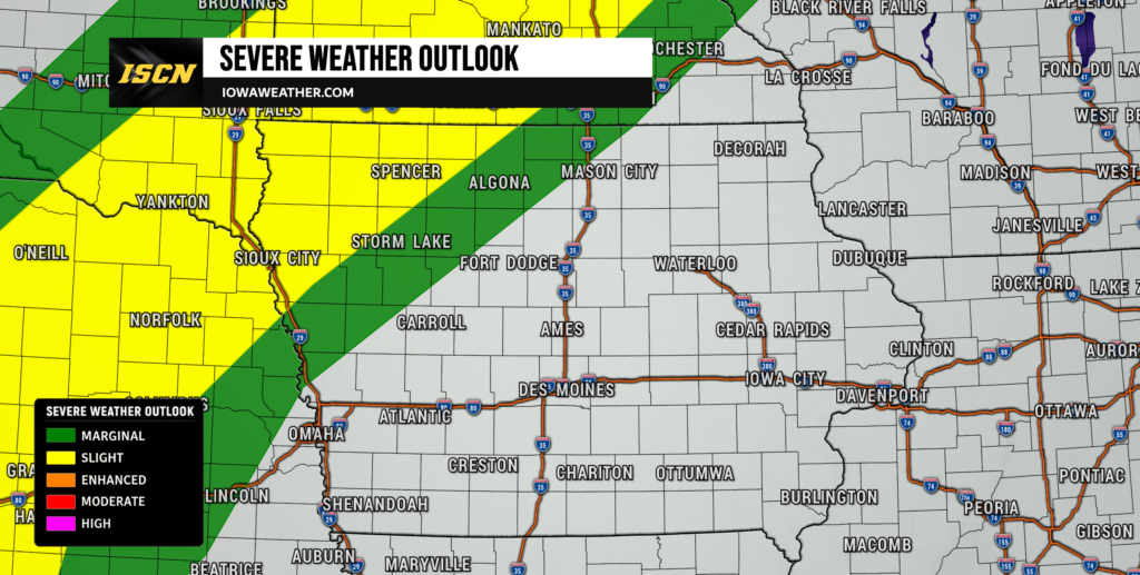
Attention then turns to scattered thunderstorms that could develop across northern and northwestern Iowa later today and tonight. Most Iowa communities will remain dry, but a few storms near the Minnesota and Nebraska borders could become strong, with hail and gusty winds the primary concerns. Another cold front will bring additional thunderstorm chances Friday, including a possibility of a few stronger storms in portions of the state. The overall severe weather threat remains limited, however, and a pleasant stretch of mostly dry weather is expected to settle into Iowa for much of the weekend.
Dense Fog Affecting Parts of Iowa Thursday Morning
Fog is creating the first weather concern of the day, with locally dense fog reducing visibility across portions of Iowa Thursday morning. The greatest impacts have generally developed where recent rainfall has left wet soils, allowing moisture near the ground to condense as temperatures cooled overnight. River valleys are also more susceptible, including portions of southern and western Iowa, while dense fog has been observed across parts of northwest Iowa. A Dense Fog Advisory was in effect for portions of northwest Iowa Thursday morning, and other pockets of dense fog have been reported around the state.
Visibility can change considerably over short distances, so drivers may encounter clear conditions followed quickly by much thicker fog. Anyone traveling during the morning commute should allow extra following distance and be prepared for sudden reductions in visibility. The fog should gradually improve through midmorning as temperatures rise and daytime mixing begins. Once that happens, visibility will improve quickly in most locations. Fog is not expected to remain a significant issue through the afternoon.
Pleasant Weather Develops for Most of Iowa Today
Once the morning fog burns away, Thursday’s Iowa weather forecast is fairly pleasant for most of the state. High pressure moving across the region will provide plenty of dry weather, with sunshine and some passing clouds. Afternoon temperatures should generally reach the upper 70s to lower 80s, which is close to normal for this point in August. Humidity will also remain more comfortable than during some of the hotter stretches Iowa has experienced this summer.
Most of Iowa will not see rain during the daytime hours, making Thursday afternoon favorable for outdoor activities and travel. Eastern Iowa should be especially quiet through much of the day, while attention begins shifting toward northwest Iowa later in the afternoon. Winds will remain relatively light for much of the state before gradually changing as the next disturbance approaches. For anyone searching for the weather today, the simple takeaway is that most of Thursday will be dry, seasonal and comfortable. The more active part of the forecast arrives later this evening and tonight.
Thunderstorms Possible Across Northern Iowa Tonight
A disturbance dropping southeast within the upper-level flow will approach the region late Thursday, bringing scattered thunderstorm chances to northern Iowa. Storms are expected to initially develop farther north and west, with the greatest potential for thunderstorms reaching northwest Iowa during the late afternoon and evening. Coverage should remain fairly limited, meaning many locations will receive no rain at all. Storm chances may spread farther east across northern Iowa tonight, although storms should gradually encounter a less favorable environment as they move deeper into the state.
The atmosphere near northwest Iowa could contain enough instability for an isolated strong to severe thunderstorm, particularly near the South Dakota, Minnesota and Nebraska borders. Farther north and west, the environment could support rotating storms capable of producing large hail and damaging winds. The greatest severe weather potential is expected to remain outside Iowa, but residents in northwest Iowa should still keep an eye on the weather radar through the evening. Storms that move farther southeast into Iowa are expected to become increasingly elevated and encounter less instability, which should reduce their ability to remain severe. Confidence is therefore higher in scattered thunderstorms occurring somewhere across northern Iowa than in widespread severe weather developing across the state.
Another Round of Storms Possible Friday
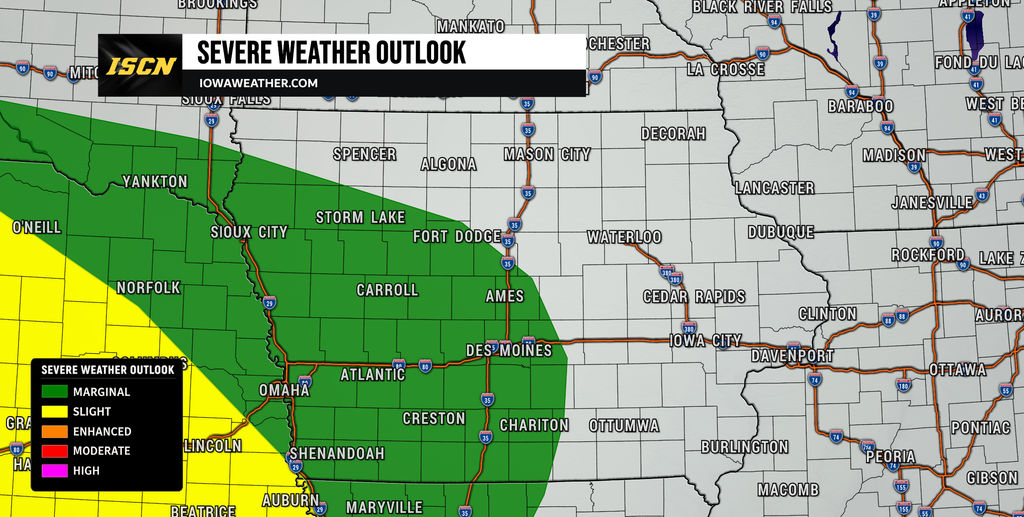
The weather becomes somewhat more complicated Friday as a cold front moves through Iowa. The exact timing of that front remains uncertain, and that will have a major influence on when and where thunderstorms develop. Some forecast guidance brings the boundary through earlier in the day, while other solutions hold it back until later Friday afternoon or evening. That difference matters because a slower front would give the atmosphere more time to warm and become unstable ahead of it.
Eastern Iowa could see instability build considerably Friday afternoon if morning clouds and showers do not interfere with daytime heating. Forecast guidance indicates that enough instability could develop for scattered thunderstorms along the cold front, while wind shear appears more modest than in the environment farther west across Nebraska. That should make widespread organized severe weather less likely, although a few stronger storms capable of producing gusty or locally damaging winds cannot be ruled out. Southern and western Iowa may also see thunderstorm chances Friday night as another disturbance interacts with the boundary. Confidence in the exact location and coverage of Friday’s storms remains moderate to low, so changes to the forecast are possible as the timing of the front becomes clearer.
Mostly Dry and Comfortable Weekend Ahead
Behind Friday’s cold front, high pressure should build into Iowa and provide a pleasant start to the weekend. Saturday currently looks like the best day for outdoor plans, with much of the state expected to remain dry. Temperatures should generally stay in the upper 70s and lower 80s, while northerly winds bring somewhat drier air into the region. Humidity should remain manageable, making conditions feel comfortable for late August.
Sunday also appears mostly dry for much of Iowa, although confidence begins to decrease as additional weak disturbances move through the northwest flow aloft. A stray shower or thunderstorm cannot be completely ruled out, but widespread rain is not currently expected. The limited return of Gulf moisture behind Friday’s front should make it difficult for storms to become widespread over the weekend. Eastern Iowa may remain dry through an even longer portion of the weekend and into early next week. Overall, the weekend weather forecast favors seasonal temperatures and considerably more dry time than wet weather.
Stay with IowaWeather.com for the latest Iowa weather updates, live radar, storm tracking and changes to the forecast. We will continue to monitor tonight’s thunderstorms, Friday’s cold front and the potential for additional storms as we move into next week.