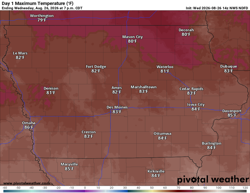
Iowa gets a break from the more active weather pattern through the end of the workweek, with mostly dry conditions, lower humidity and seasonable temperatures taking over. A cold front moving through the state Wednesday morning is helping sweep the muggy air southward, although some fog and a few showers remain possible early in the day. Most of Iowa will turn mostly sunny by afternoon with highs generally in the lower to middle 80s.
The quieter weather will not last through the entire weekend. Warmer and increasingly humid air will begin returning Friday, followed by several opportunities for showers and thunderstorms from Friday night into early next week. The first round may favor western and northern Iowa late Friday night into Saturday morning, while additional storm chances become possible later in the weekend. There are still important questions about the exact timing and strength of each round, so confidence in the overall pattern is considerably higher than confidence in the day-to-day storm details.
Breezy and Less Humid Across Iowa Today
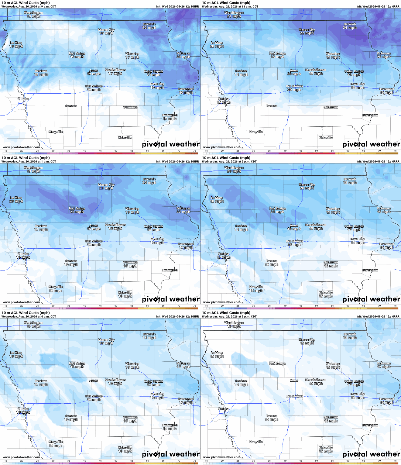
Wednesday’s weather will improve across most of Iowa as a cold front continues moving south through the state. Behind the front, noticeably drier air is arriving from the northwest, which will gradually push the higher humidity southward and leave much of the state with a comfortable afternoon. Temperatures should reach the lower to middle 80s across much of Iowa, making today’s temperature close to what we would expect for late August. Northwest winds will become breezy behind the front, with gusts around 20 to 25 mph possible, especially across northern and eastern Iowa. Despite the stronger wind, widespread hazardous weather is not expected during the afternoon, and most locations should experience plenty of sunshine.
There is a small exception to the otherwise dry forecast early Wednesday. A few isolated showers or thunderstorms are possible across far eastern Iowa as the front passes through during the morning, but moisture and atmospheric forcing are limited. Any rain that develops should be brief and light, with the chance quickly decreasing as the front moves away. If you are wondering whether it will rain today, the answer for most Iowa communities is no, especially from late morning through the afternoon. The best chance for a brief morning shower will be toward the Mississippi River and northeastern portions of the state.
Pleasant Weather Continues Thursday and Much of Friday
Thursday looks like one of the quieter days in the Iowa weather forecast this week. High pressure will settle across the region, keeping the state dry while winds become much lighter than Wednesday. Afternoon temperatures will again generally reach the upper 70s to middle 80s, with the coolest readings likely across northern Iowa. Humidity should remain relatively comfortable, and mostly clear skies are expected across much of the state. Anyone with outdoor plans Thursday should have few weather-related problems, and no organized severe weather is expected.
Most of Friday should also remain dry as the center of high pressure moves east and the weather pattern begins changing. Southerly flow will gradually develop behind the departing high, allowing warmer air and moisture to start returning north into Iowa. Temperatures should climb farther into the 80s, particularly across western Iowa, while humidity slowly increases. Thunderstorms appear unlikely for most of the daytime hours Friday because the atmosphere should remain capped, meaning warm air aloft will initially prevent storms from developing. That cap becomes less reliable Friday night as the first disturbance approaches from the west.
Thunderstorm Chances Return Friday Night
The first meaningful chance for thunderstorms arrives late Friday into Friday night as the quiet pattern begins to break down. A disturbance moving through the Plains will encounter increasingly warm and humid air, while a strengthening low-level jet — a ribbon of faster winds a few thousand feet above the ground — helps transport moisture northward. Thunderstorms may initially develop west of Iowa before spreading toward portions of western and northern Iowa Friday night. Current probabilities generally support scattered rather than widespread storms, so not everyone will necessarily receive rain from this first round. The timing and placement of the disturbance remain somewhat uncertain, which keeps confidence moderate in thunderstorms occurring somewhere in the region but lower for any specific Iowa community.
There is also some potential for stronger thunderstorms near the western edge of the region Friday evening and night. The atmosphere may contain enough instability and changing wind speed with height to support stronger storms, but several ingredients still need to line up correctly. At this point, the more notable severe weather potential appears focused west of Iowa, although western Iowa will need to monitor how the forecast evolves. This does not currently look like a reason to cancel Friday evening plans across the state. It is, however, worth checking the latest local weather forecast before high school football games and other outdoor events Friday night, especially in western Iowa.
More Active Weather Pattern Develops This Weekend
The larger change in Iowa weather arrives this weekend as the upper-level ridge responsible for the quieter conditions shifts east. That will place Iowa within a more active west-to-east or southwest-to-northeast storm track, allowing several disturbances to move through the region. The first round could be ongoing Saturday morning following Friday night’s activity, followed by additional opportunities for thunderstorms later Saturday, Sunday and into early next week. There will almost certainly be dry periods between these rounds, so the forecast should not be interpreted as an all-day rainout throughout the weekend. Pinning down exactly when those dry windows occur will become easier as the individual disturbances move closer and higher-resolution weather models can resolve them more clearly.
Confidence is relatively high that Iowa is moving into a wetter and more active pattern, but confidence in individual thunderstorm timing remains low. Forecast models agree on the broader pattern change while still differing on the strength, track and timing of the smaller disturbances responsible for each round of rain. Those differences are important because a shift of only several hours can substantially change instability and the potential for severe weather. For that reason, it is too early to assign much confidence to severe storm potential Saturday through early next week. Anyone with weekend outdoor plans should continue checking the weather forecast rather than focusing on a single rain percentage several days in advance.
Heat and Humidity Build by Sunday
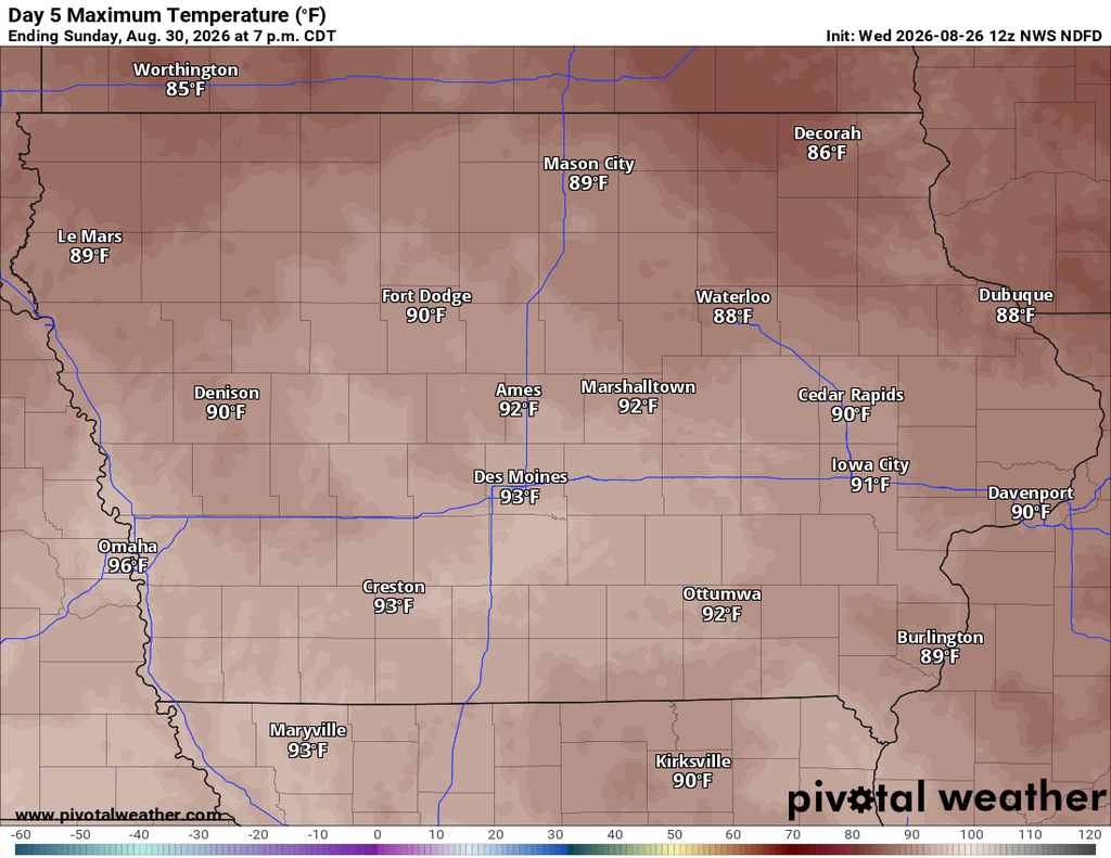
Along with the returning thunderstorms, Iowa will experience a noticeable increase in warmth and humidity this weekend. Southerly winds will transport Gulf moisture back into the state as temperatures climb from the 80s Friday toward the upper 80s and potentially lower 90s in parts of Iowa over the weekend. Sunday currently appears to be one of the warmer and more humid days, with heat index values potentially reaching the 90s. That is not an unusual level of heat for late August, but it will feel noticeably different after the lower humidity Wednesday and Thursday. Western Iowa may warm more quickly, while clouds and thunderstorms could influence the exact temperature in other portions of the state.
The amount of heating will also depend heavily on the timing of weekend thunderstorms. Locations that remain dry and sunny for several hours could warm considerably, while areas affected by morning clouds or rain may stay cooler than currently forecast. This is one reason exact high temperatures several days out should be treated with some flexibility. There is good confidence that humidity will increase, but lower confidence regarding which locations ultimately experience the hottest conditions. At this point, widespread dangerous heat does not appear to be the primary weather concern, but the return of summer humidity will be noticeable.
Heavy Rain Potential Will Need to Be Watched
The return of deeper moisture means some thunderstorms could produce locally heavy rain, especially beginning Friday night and continuing through the weekend. Atmospheric moisture is expected to increase significantly as southerly flow strengthens, giving thunderstorms access to more water vapor than has been available during the quieter midweek pattern. The initial Friday night storm complex should generally be progressive, meaning storms are expected to keep moving rather than repeatedly sitting over the same locations. That movement should limit the widespread flooding risk with the first round. Still, locally heavy downpours could occur beneath stronger thunderstorms.
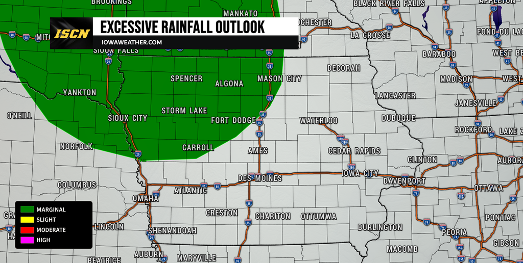
The bigger question will be what happens if multiple rounds of rain affect the same areas through the weekend and early next week. A frontal boundary may eventually slow or stall somewhere in the region, which could create repeated opportunities for thunderstorms. Exactly where that boundary sets up remains uncertain and will play a major role in determining which parts of Iowa receive the most rain. There is not enough confidence yet to identify a corridor for significant flooding in Iowa, and the current excessive rainfall outlook keeps the more organized Friday-to-Saturday risk primarily northwest of the state. Rainfall trends will need to be monitored as the weekend approaches, particularly if later forecasts begin concentrating several rounds of thunderstorms over the same portion of Iowa.
Looking Ahead
The Iowa weather pattern appears likely to remain unsettled beyond the weekend. Southwest flow developing higher in the atmosphere should continue sending disturbances toward the Upper Midwest, maintaining periodic chances for rain and thunderstorms into Monday and potentially beyond. A frontal boundary may also linger somewhere across the region Sunday into Monday, providing an additional focus for thunderstorm development. There is growing confidence in an active overall pattern but much less confidence regarding the timing, location and severity of individual storm rounds. Severe weather could eventually become a concern if stronger instability and wind shear overlap, but it is simply too early to determine whether that will happen in Iowa.
For now, the most predictable part of the forecast is the pleasant stretch through Thursday and much of Friday, followed by increasing warmth, humidity and storm opportunities beginning Friday night. Saturday through early next week will require more day-to-day forecast adjustments as individual disturbances become easier to track. Residents with outdoor events this weekend should pay particular attention to updated thunderstorm timing rather than assuming an entire day will be wet. Keep an eye on the latest radar, forecast and severe weather updates as the pattern evolves. Stay with IowaWeather.com for the latest Iowa weather forecast and updates as we get a clearer picture of this weekend’s thunderstorms.