Iowa gets one more relatively comfortable late-summer day Friday before the weather pattern begins changing this weekend. Most of the state will stay dry through the daytime with sunshine, light winds and afternoon temperatures generally in the lower to middle 80s. Patchy fog early Friday morning may briefly reduce visibility, especially in river valleys and portions of northern and northeastern Iowa, before quickly improving after sunrise.
The bigger changes arrive late Friday night into Saturday as thunderstorms move toward northern Iowa, followed by a surge of much warmer and more humid air. Sunday currently looks like the hottest day of the weekend, with widespread 90s and heat index values approaching 100 degrees in parts of the state. Iowa then enters a more active weather pattern next week, although exactly when thunderstorms provide relief from the heat remains uncertain.
Thunderstorms Return Late Friday Night Into Saturday
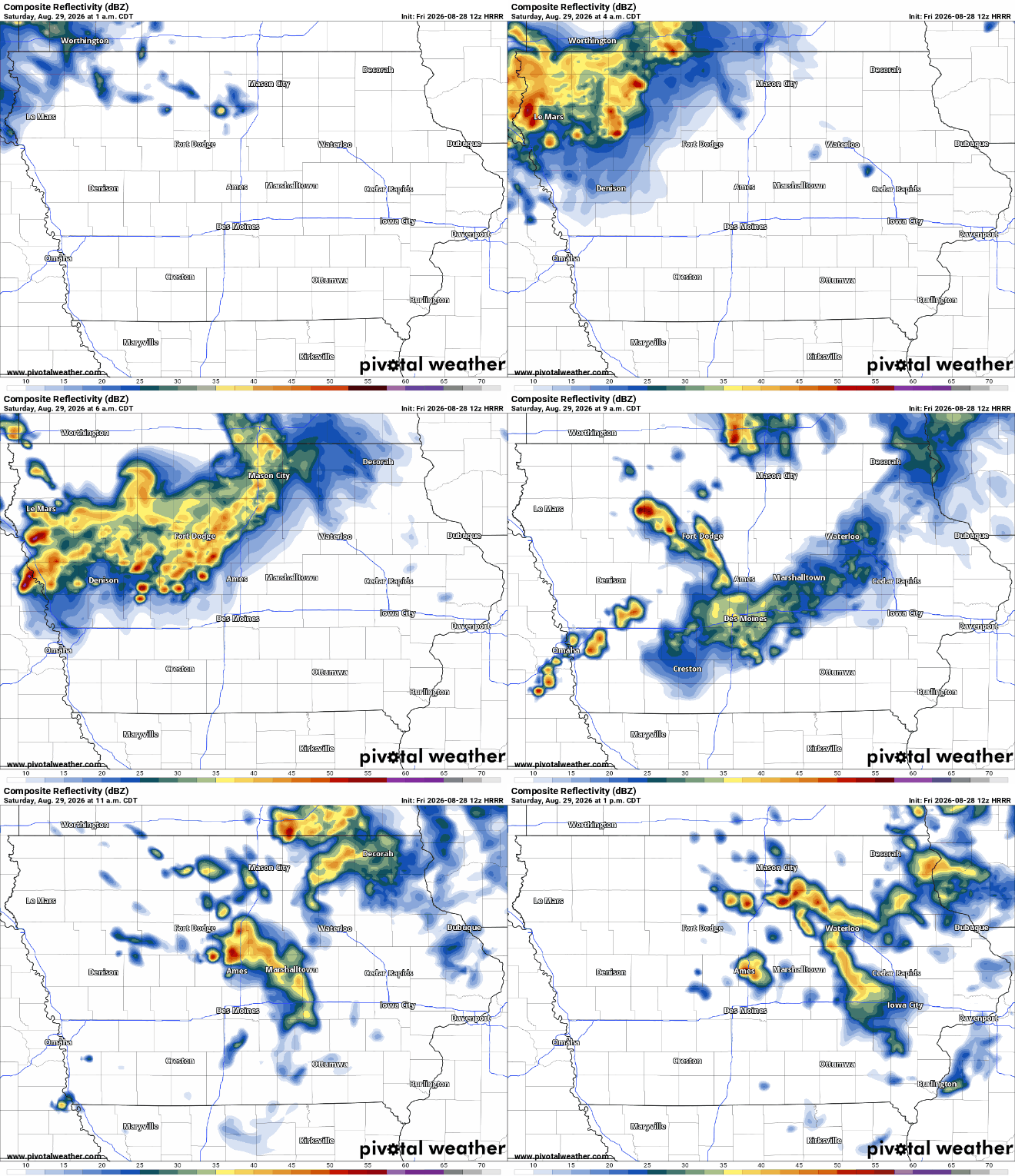
Rain and thunderstorm chances increase late Friday night as a disturbance moves across the northern Plains and eventually into Iowa. Thunderstorms are expected to initially develop farther northwest before moving east and southeast overnight, placing northern and northwestern Iowa in the most likely path toward early Saturday morning. The atmosphere will contain enough instability and wind shear to maintain some stronger storms, although there are questions about how organized the thunderstorms will remain by the time they reach Iowa. Current guidance generally shows storms weakening as they move into the state, which keeps the overall severe weather threat relatively low. If a stronger cluster survives into northwest Iowa, gusty winds would be the primary concern during the overnight and early morning hours. Residents across northern Iowa should check the weather radar before traveling Saturday morning because the timing and strength of the storms may continue to change.
The highest rain chances should generally favor northern Iowa, while locations farther south have a better opportunity to remain dry. Eastern Iowa may see a weakening area of showers or thunderstorms move through Saturday morning, particularly north of Interstate 80, but rainfall amounts there are expected to be relatively light. Many locations in eastern Iowa may receive less than one-tenth of an inch if the storms continue weakening as expected. The majority of the showers and thunderstorms should shift east during Saturday, allowing drier weather to return from west to east. How quickly morning clouds and rain depart will also have an impact on Saturday afternoon temperatures. Confidence is moderate on the overall evolution but lower regarding exactly how strong the overnight storms will remain as they cross Iowa.
Temperatures Begin Climbing Saturday
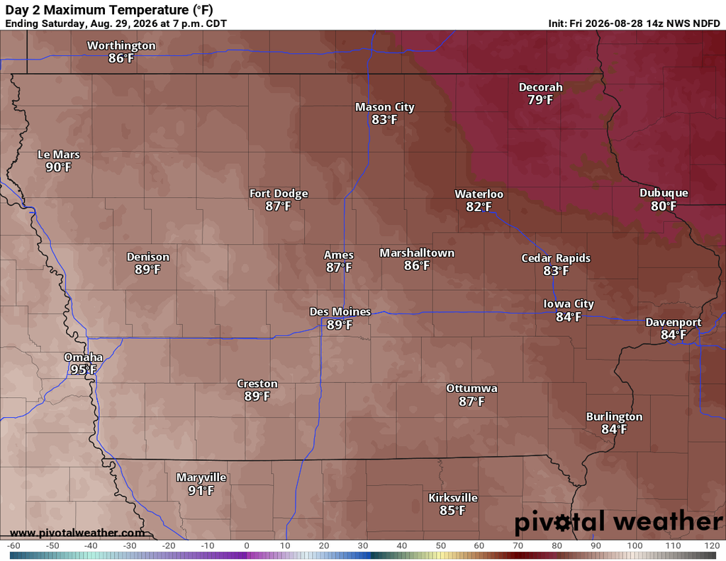
Saturday marks the beginning of a noticeable warming trend, although morning thunderstorms and cloud cover could complicate the temperature forecast. Western and southern Iowa have the best chance to warm substantially during the afternoon, with temperatures approaching 90 degrees in some locations as sunshine returns. Eastern Iowa should be somewhat cooler, with highs generally around 80 to the lower 80s where clouds may linger longer. Southerly winds will strengthen behind the departing disturbance and begin transporting warmer, increasingly humid air into the state. Western Iowa could also become breezy during the afternoon as the atmosphere mixes more efficiently. If Saturday morning thunderstorms produce a larger area of rain-cooled air than currently expected, afternoon temperatures could finish several degrees cooler in parts of Iowa. Confidence is therefore higher in the warming trend than in the exact Saturday high temperature for any individual location.
Late-Summer Heat Builds Sunday
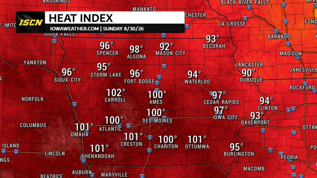
Sunday is expected to bring the most significant change in Iowa’s weather as late-summer heat spreads across the state. High temperatures are forecast to reach the lower to middle 90s across a large portion of Iowa, with some of the hottest readings likely across western, central and southern portions of the state. Humidity will also increase as southerly winds transport more moisture northward, making it feel considerably hotter than the actual air temperature. Heat index values could approach 100 degrees in some areas Sunday afternoon, especially where temperatures reach the middle 90s. Northwest Iowa may also climb well into the 90s after a considerably warmer and more humid air mass expands eastward. Anyone spending significant time outdoors Sunday should plan for the combination of heat and humidity rather than focusing only on the forecast temperature.
This heat is developing as a strong ridge of high pressure in the upper atmosphere expands across the central United States. Air beneath this ridge sinks and warms, while southwest and southerly winds near the surface transport additional heat and moisture into Iowa. That combination will produce above-normal temperatures as August comes to an end, and the heat is unlikely to disappear immediately once the weekend is over. Central and southern Iowa could experience heat index readings near 100 degrees again Monday, while eastern Iowa may see similar conditions at times into next week. There remains some uncertainty over exactly how hot individual days become because thunderstorms, clouds and subtle changes in the position of the ridge could lower temperatures. Confidence is high, however, that Iowa is entering a stretch of hotter and more humid weather.
Another Severe Weather Chance Develops Sunday
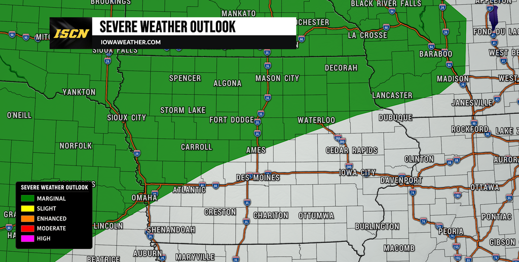
Thunderstorm chances return to parts of the region Sunday as a cold front approaches from the northwest, although much of Iowa could remain dry for a significant portion of the day. A Marginal Risk, level 1 of 5, for severe thunderstorms extends across portions of the northern and central Plains into the Upper Mississippi Valley. The most favorable combination of instability and wind shear appears focused north and northwest of much of Iowa, but northwest Iowa will need to be monitored as storms approach the region. Any stronger storms that develop could produce damaging wind gusts and large hail, especially closer to the warm front and advancing cold front. The atmosphere may also contain a layer of warm air aloft, commonly called a cap, that could suppress thunderstorm development despite the heat and humidity near the ground. Because of that uncertainty, confidence in widespread severe weather across Iowa Sunday remains low.
If thunderstorms successfully develop farther northwest, they could organize into clusters and potentially move toward portions of Iowa later Sunday or Sunday night. The atmosphere should contain enough instability for thunderstorms to become strong where they can overcome the cap, but exactly where that occurs remains uncertain. Northern and northwest Iowa currently deserve the closest attention, while central and southern Iowa appear more likely to spend much of Sunday under the hot air mass. Damaging winds and hail would be the primary severe weather hazards with any organized storms. The severe weather forecast may become more focused as higher-resolution guidance gets a better handle on the strength and location of the front. Iowa residents with Sunday evening plans should continue checking the local weather forecast and live weather radar as the weekend progresses.
Storm Chances Continue Into Early Next Week
Iowa’s weather pattern becomes more unsettled heading into Monday and Tuesday as the upper-level ridge begins to flatten. Several smaller disturbances are expected to travel through the faster flow surrounding the ridge, creating periodic opportunities for showers and thunderstorms. These are not expected to produce continuous rain, meaning Iowa will likely experience substantial dry periods between individual rounds of storms. Current trends suggest one of the better opportunities may develop around Monday evening into Tuesday as a cold front pushes farther into the state. Evening and overnight hours may generally offer the better thunderstorm chances, particularly across western and northern Iowa. Forecast confidence decreases considerably regarding exact timing and storm coverage after the weekend because computer models disagree on the placement and strength of the ridge.
That uncertainty will also influence the severe weather and rain forecast next week. A stronger ridge would tend to push the main storm track farther north and keep more of Iowa hot and relatively dry, while a weaker or displaced ridge would allow thunderstorms to travel farther south into the state. Eastern Iowa currently has particularly large temperature uncertainty next week because of questions surrounding precipitation and the eventual movement of the upper ridge. Available guidance supports keeping periodic rain chances in the forecast rather than identifying any single day as a statewide washout. Heavy rain could become a localized concern where thunderstorms repeatedly move across the same locations, but there is not enough confidence yet to identify a significant flooding threat for Iowa. Residents should expect the forecast for individual days to become more precise as each disturbance gets closer.
Above-Normal Temperatures May Last Into September
The return of the 90s this weekend may be the beginning of a longer period of above-normal temperatures rather than a brief burst of heat. Much of Iowa should remain in the upper 80s to lower 90s during at least portions of next week, although thunderstorms could temporarily interrupt the heat. Eastern Iowa has the potential for dew points to reach the upper 60s and lower 70s, which would keep humidity noticeably elevated. Longer-range temperature guidance also favors near- to above-normal temperatures during the opening days of September. The biggest question is where the upper-level ridge settles and how frequently storm systems can push through it. Confidence is relatively high in temperatures averaging warmer than normal, but lower in predicting which individual days will be the hottest.
The position of the ridge will ultimately determine both the temperature forecast and the frequency of thunderstorms. If it remains strong over or just south of Iowa, hot conditions could persist while many storm systems track north of the state. If the ridge weakens or shifts, fronts and disturbances would have an easier path into Iowa and could provide temporary relief from the heat. This is why individual high-temperature forecasts next week still have a fairly wide range among weather models. It is also why a 7 day forecast will likely undergo several adjustments as the pattern evolves. For now, Iowa residents should plan on a warmer and more humid stretch with occasional thunderstorms rather than an immediate return to prolonged cooler weather. The overall pattern favors late-summer heat continuing as the calendar turns toward September.
Keep checking IowaWeather.com throughout the weekend for the latest Iowa weather forecast, storm timing, heat updates and changes to the severe weather outlook as new forecast data arrives.