A stretch of unusually hot and humid weather is about to settle over Iowa as August comes to a close and September begins. Temperatures will climb Sunday and remain well above normal through at least the middle of next week, with the most significant heat expected across southern Iowa. Afternoon heat index values could reach 100° to 103° at times, while warm overnight temperatures may provide little relief. Northern Iowa will have a somewhat different weather story, with periodic thunderstorms and cloud cover potentially holding temperatures down on some days.
This will not be a completely dry stretch, but widespread rain is not expected either. Several weak disturbances will travel around the northern edge of the expanding heat dome, creating intermittent chances for showers and thunderstorms from Sunday through the middle of next week. The best opportunities for rain will generally favor northern Iowa, especially during the overnight and early morning hours. Exactly where those storms develop will play an important role in determining how far north the hottest temperatures can spread.
Late-Season Heat and Humidity Build Sunday Through Wednesday
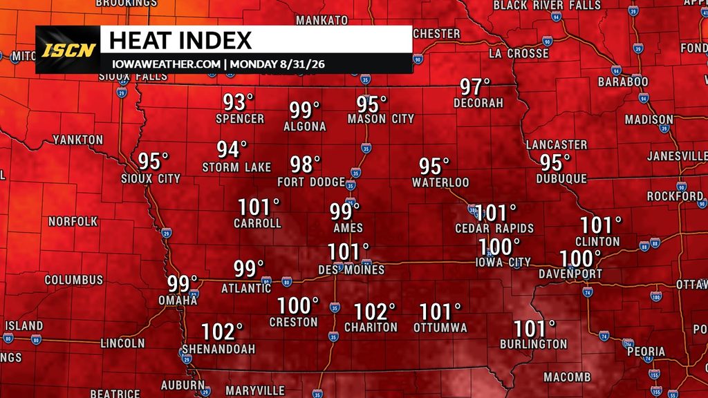
Sunday marks the beginning of a much hotter stretch of weather across Iowa as a strong ridge of high pressure expands into the central United States. High temperatures will generally reach the upper 80s and 90s, with western and southern Iowa likely experiencing the hottest conditions. Humidity will make it feel even warmer, and heat index values could climb into the upper 90s or low 100s across parts of western and southern Iowa Sunday afternoon. The heat becomes more persistent Monday through at least Wednesday, when southern Iowa could experience several afternoons with heat index values around 100° to 103°. Northern Iowa may occasionally run cooler because it will remain closer to a boundary where clouds and thunderstorms have a better opportunity to develop. Confidence is high that temperatures will remain above normal, although the exact afternoon highs will depend heavily on cloud cover and storm development.
There is some uncertainty regarding just how high actual temperatures will climb, particularly across southern Iowa. Some forecast guidance has been considerably hotter than the overall blend of available data, including scenarios that push temperatures close to 100°. Those extreme readings are not currently the most likely outcome, but temperatures well into the 90s remain possible. The combination of heat and humidity is more important than the exact afternoon temperature because it determines how efficiently the body can cool itself. This will be an unusually hot period for the end of August and beginning of September, even if widespread 100° air temperatures do not occur. Anyone spending extended time outdoors should plan for summerlike heat despite the calendar moving toward meteorological fall.
Extreme Heat Risk Is About More Than the Afternoon Heat Index
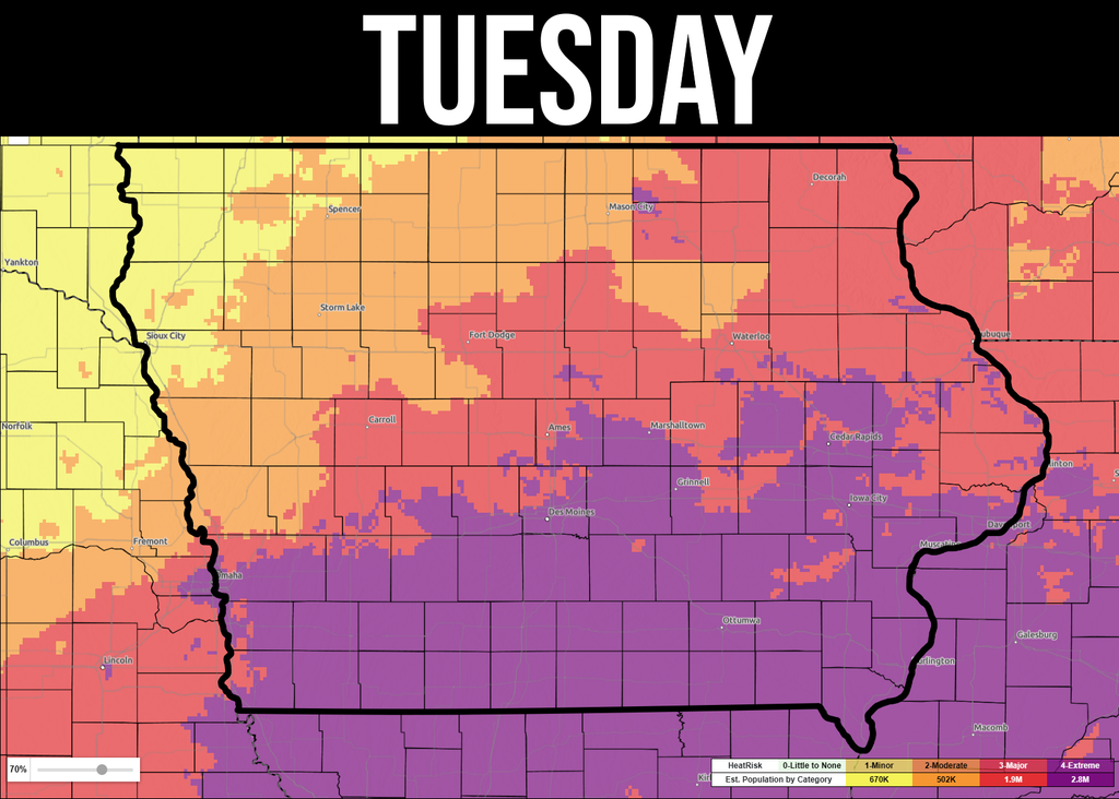
One of the more important elements of this late-season heat wave will be the lack of meaningful cooling overnight. Experimental Heat Risk guidance reaches the Extreme, or Level 4 of 4, category across portions of southern Iowa during the upcoming stretch. That classification considers more than the maximum afternoon heat index and accounts for factors such as how unusual the heat is, how long it lasts and whether temperatures cool sufficiently at night. Overnight lows could remain in the mid to upper 70s across southern Iowa Monday night through at least Wednesday night. Some locations may challenge or break records for the warmest minimum temperature on those dates. When nights remain that warm, homes without adequate air conditioning and people who work or spend long periods outside have less opportunity to recover from daytime heat.
Heat stress can build over several consecutive days even when daytime heat index values remain below traditional Heat Advisory criteria. Current projections generally keep peak heat index values below 105°, but repeated readings near 100° to 103° combined with very warm nights can still create meaningful health concerns. Older adults, young children, people with certain health vulnerabilities and anyone without reliable cooling should pay especially close attention to the weather this week. Outdoor workers and athletes should also consider adjusting strenuous activities toward the cooler parts of the day. Drinking water regularly and taking breaks in air-conditioned or shaded areas will become increasingly important as the heat builds. Confidence in a multi-day period of unusually warm and humid conditions is increasing, especially across the southern half of Iowa.
Periodic Thunderstorm Chances Favor Northern Iowa
The heat will not eliminate rain chances completely, especially across the northern half of Iowa. A nearly stationary boundary is expected to remain close to northern Iowa while several small upper-level disturbances move along the northern side of the heat dome. That setup can produce rounds of scattered thunderstorms, with the most favorable timing often occurring overnight into the early morning hours. Rain chances will generally remain in the 20% to 40% range at any one time through the first part of the week, meaning many locations could remain dry even when storms are in the forecast. Northern Iowa has the best overall opportunity for thunderstorms, while southern Iowa should experience longer stretches of dry and hot weather. Forecast confidence is moderate on the overall pattern but lower on the exact timing and placement of individual storm clusters because relatively subtle disturbances will determine where they form.
Sunday could bring another round of isolated to scattered showers and thunderstorms, particularly across northern and eastern Iowa. Some storms could also develop farther west or southwest, although widespread coverage is not expected. Any thicker cloud cover or rain that develops during the daytime would temporarily lower temperatures and could significantly affect the afternoon heat index in that area. Additional thunderstorm opportunities return Sunday night into Monday and continue periodically through the middle of the week. This is not expected to be a consistently wet pattern, and rainfall amounts could vary considerably from one community to another. The rain forecast will need to be refined each day as the position of the boundary and smaller atmospheric disturbances become clearer.
Severe Weather Threat Remains Limited but Bears Watching
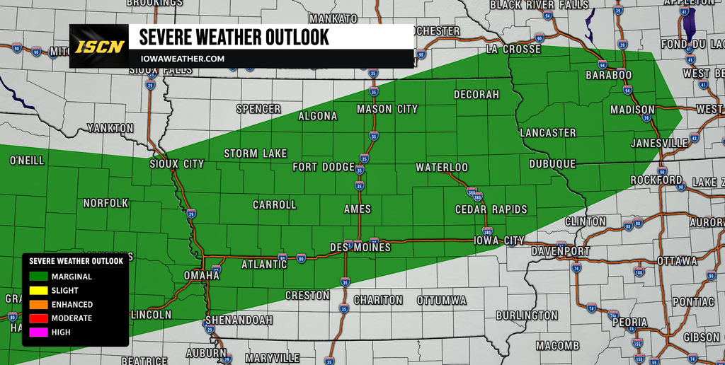
Widespread severe weather is not currently expected Sunday, although a stronger isolated thunderstorm could produce gusty winds or small hail. The atmosphere will contain plenty of instability because of the heat and humidity, but relatively weak wind shear should limit how organized most storms can become. Monday brings a somewhat greater concern as a weak boundary remains stretched from the Plains toward the Upper Midwest and Corn Belt. A Marginal Risk for severe thunderstorms highlights the potential for isolated storms capable of damaging wind gusts or hail Monday afternoon and evening. Northern Iowa will be closer to the more favorable zone for storm development, but storm coverage may remain limited because forcing is weak and warmer air aloft could suppress thunderstorm growth. Confidence in a widespread severe weather event is low at this time.
The severe weather potential may need to be watched again around the middle of the week. Forecast guidance shows additional disturbances moving through the region as the upper-level ridge gradually weakens and becomes less dominant. Wednesday and Thursday currently have some signals for stronger thunderstorms, particularly if a weak cold front can interact with the hot and humid air mass over Iowa. It is too early to determine specific timing, locations or hazards, and those details will depend on how thunderstorms earlier in the week alter the atmosphere. For now, the more important message is that periodic storm chances will accompany the heat rather than a major organized severe weather outbreak being imminent. Residents should continue checking updated forecasts and weather radar as individual storm periods come into better focus.
Where Will the Hottest Weather Be in Iowa?
Southern Iowa continues to have the highest confidence for several consecutive days of significant heat. Communities from southwest Iowa through south-central and southeast Iowa could experience afternoon temperatures well into the 90s along with heat index values near or above 100°. Central Iowa will also be hot and humid, but occasional clouds or thunderstorms could create more day-to-day variation in temperatures. Northern Iowa will remain closest to the primary storm track, increasing the likelihood that rain and cloud cover periodically interrupt the heat. Eastern Iowa will warm substantially beginning Sunday, with the most persistent heat expected south of Interstate 80 while areas farther north have a better chance of seeing storm-related cooling. Even in locations that avoid triple-digit heat index readings, temperatures will remain well above normal for late August and early September.
Western Iowa will also experience very warm conditions, particularly Sunday when highs in some areas may reach the mid to upper 90s. Heat index values around 100° are possible near the Missouri River Valley before slightly cooler temperatures arrive behind a weak front farther northwest. The front will not bring a major push of cool air into the entire state, however, allowing summerlike temperatures to continue next week. Northeast Iowa may have some of the greatest temperature uncertainty because that region is closer to repeated thunderstorm chances. A storm complex arriving at the right time could keep a location considerably cooler than surrounding areas that remain sunny. That makes daily updates especially important when planning outdoor activities during this pattern.
For now, Iowa residents should prepare for several days that feel more like the heart of summer than the end of August. Pay particular attention to the warm nighttime temperatures because several days without significant overnight cooling can increase heat stress. Keep checking IowaWeather.com for the latest Iowa weather update, thunderstorm timing, severe weather information and changes to the heat forecast as new data arrives.