Iowa remains stuck in a very moist and active weather pattern Friday, with several more rounds of rain and thunderstorms expected before conditions gradually improve next week. Showers and thunderstorms were already affecting portions of northern Iowa early Friday morning, and additional storms may develop later today as a weather system moves across the region. The biggest concern over the next 36 to 48 hours will be locally heavy rainfall, especially across northern and eastern Iowa where repeated rounds of rain could lead to flooding.
There is also a conditional risk for severe thunderstorms Friday afternoon and evening. Whether stronger storms develop will depend heavily on how much Iowa can warm after the morning rain and cloud cover. If enough sunshine develops, the atmosphere could become quite unstable and support a few severe thunderstorms. Additional thunderstorms are expected Saturday before cooler, more fall-like temperatures spread across Iowa for Sunday and much of next week.
Morning Rain Gives Way to a Potential Afternoon Break
Showers and thunderstorms moving through northern Iowa Friday morning should gradually decrease from west to east, allowing much of the state to experience a break later in the morning. Some of the early thunderstorms are capable of producing brief heavy rain because the atmosphere contains unusually high amounts of moisture for mid-September. Ponding of water may occur in poor-drainage areas, but widespread flooding from the morning activity alone is not expected. The duration of the break will be important because any clearing would allow temperatures to climb quickly during the afternoon. Much of western and central Iowa could reach the 80s, with some locations in western Iowa potentially approaching the lower 90s. Areas that remain cloudy longer will stay cooler and may also experience a lower severe weather risk later in the day.
Hot and Humid Air Builds Ahead of the Next System
Friday afternoon will feel more like summer than late September across portions of Iowa as warm, humid air continues flowing north. Dew points in the lower 70s will provide plenty of moisture for thunderstorms, while afternoon heating could produce considerable instability. Forecast guidance indicates roughly 2,000 to 3,000 J/kg of instability may develop in parts of the state, which is more than enough to support strong thunderstorms if storms can break through a layer of warmer air aloft known as a cap. That cap is one of the biggest uncertainties in today’s weather forecast because it could prevent thunderstorms from fully developing despite the warm and humid conditions near the ground. The greatest opportunity for stronger surface-based storms appears to be near a frontal boundary moving through Iowa during the afternoon and evening. Confidence is high that the atmosphere will be humid and unstable, but confidence is considerably lower regarding how many severe thunderstorms actually develop.
Isolated Severe Thunderstorms Possible Friday Afternoon and Evening
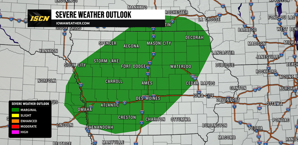
Iowa is under a Marginal Risk, Level 1 of 5, for severe thunderstorms Friday, meaning severe weather is possible but should remain isolated. Thunderstorm development may begin during the mid-to-late afternoon, with northwest and western Iowa potentially seeing stronger storms between roughly 4 p.m. and 9 p.m. before activity shifts farther east and southeast. Other storms may develop farther into central and eastern Iowa into the evening, but exactly where storms form will depend on the position of the front and whether the cap can weaken enough. Damaging wind gusts are expected to be the most common severe weather hazard, although some storms could also produce hail. Storm coverage is not expected to be uniform, meaning some Iowa communities may see thunderstorms while others remain dry for much of the afternoon. Anyone with outdoor plans Friday afternoon or evening should keep an eye on the weather radar because storms that manage to develop could strengthen relatively quickly.
A Tornado or Two Cannot Be Ruled Out
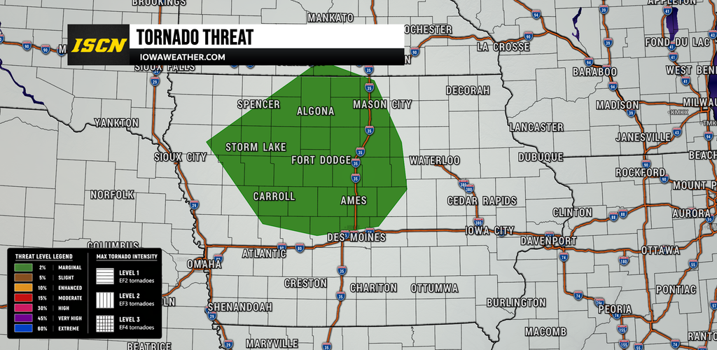
The tornado potential Friday is low, but it is not zero, particularly if thunderstorms become rooted near the surface along the warm frontal zone. Winds near the ground are expected to blow from the southeast in some areas before turning more southwesterly just above the surface, creating some rotation in the lowest part of the atmosphere. That environment could support a brief tornado with a stronger storm that develops close to the boundary. However, winds higher in the atmosphere are not especially strong, which should limit the organization and longevity of any supercell thunderstorms. Morning clouds and rain could further reduce the tornado threat if they prevent sufficient heating and keep storms elevated above the surface. This makes the tornado risk highly conditional, and damaging winds remain the more likely severe weather hazard if storms develop.
Heavy Rain and Flooding Become the Bigger Concern
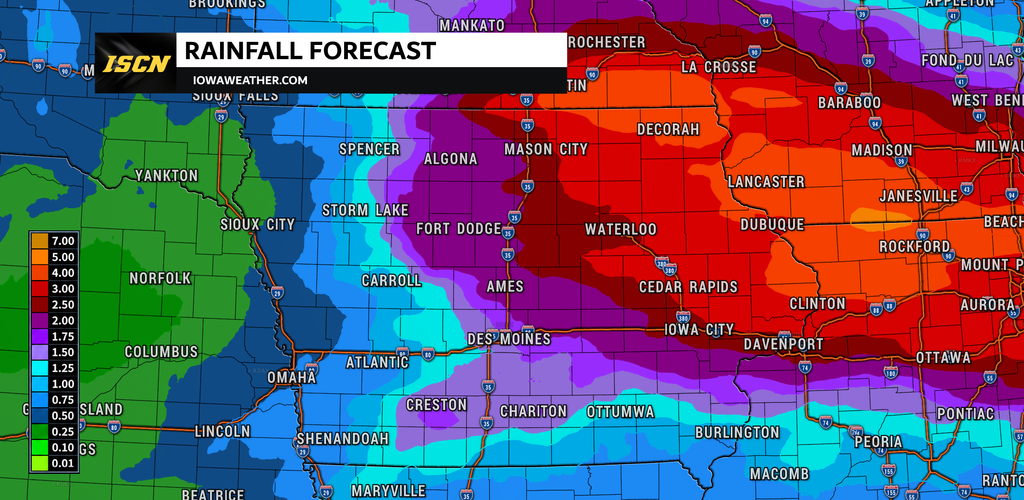
Heavy rainfall may ultimately be a more widespread concern than severe weather through Saturday because Iowa’s atmosphere is exceptionally moist. Precipitable water values, a measure of how much moisture is available through the atmosphere, are expected to approach or exceed 2 inches in many areas. Those values are near the upper end of what is normally observed in Iowa during September and will allow thunderstorms to produce very efficient rainfall. Repeated storms moving across the same locations could quickly produce several inches of rain, particularly across northern, northeastern and eastern Iowa. The Weather Prediction Center has highlighted portions of the Upper Midwest with a Slight Risk of excessive rainfall through Saturday morning, with another Slight Risk continuing into Saturday. Given the rain Iowa has already received, additional downpours could cause rapid rises on smaller creeks and streams along with flooding in low-lying, urban and poor-drainage areas.
Northeast and Eastern Iowa Face the Highest Flooding Risk
The greatest flooding concern through Saturday is focused across portions of northeastern and east-central Iowa, although the exact placement of the heaviest rain remains uncertain. In northeast Iowa, widespread rainfall totals of roughly 1 to 4 inches are possible from Friday into Saturday, with a small chance of localized amounts exceeding 5 inches. High-end guidance suggests isolated totals approaching 5 to 7 inches cannot be completely ruled out if thunderstorms repeatedly track over the same locations. Farther south into east-central Iowa, another round of heavy thunderstorms is expected Friday night, where rainfall totals of 1 to 3 inches are likely in some areas and localized amounts over 3 inches are possible. Flood Watches are in effect for portions of northeastern and east-central Iowa because saturated soils will be less capable of absorbing another round of heavy rain. The precise corridor receiving the most rain will depend on where the frontal boundary stalls, so relatively small shifts in that boundary could substantially change local rainfall totals.
More Thunderstorms Develop Friday Night
Thunderstorms should become more widespread again Friday night as winds several thousand feet above the ground strengthen and transport additional moisture into Iowa. This low-level jet will interact with the frontal boundary and may cause thunderstorms to repeatedly develop and move across northern and eastern portions of the state. The severe weather threat should gradually diminish after sunset as surface instability decreases, but a stronger elevated thunderstorm could still produce gusty winds or hail. Heavy rainfall will remain possible well after the daytime severe weather threat fades, making flooding the primary overnight concern. Some locations could experience multiple rounds of rain before Saturday morning, especially across northern and eastern Iowa. Anyone living near flood-prone roads, small streams or low-lying areas should remain alert to changing conditions overnight.
Another Round of Storms Expected Saturday
Rain and thunderstorms will remain in the Iowa weather forecast Saturday as the frontal boundary gradually moves south through the region. After some morning activity, thunderstorms should become more numerous again during the afternoon and evening, particularly across southern and eastern Iowa. The atmosphere will remain very humid, with enough instability for some thunderstorms to become strong or severe. The Storm Prediction Center indicates an isolated severe weather threat across portions of the Midwest, including parts of Iowa, with damaging winds and hail the primary concerns. Stronger storms may produce water-loaded downbursts, where the combination of heavy rain and descending air produces locally damaging wind gusts. Severe weather should again remain isolated, but the combination of thunderstorms and additional heavy rain could create problems in locations that receive repeated rounds.
Cooler, Showery Weather Arrives Sunday
A noticeable change in temperatures will follow the front this weekend, bringing a much more fall-like feel to Iowa. High temperatures Saturday will generally retreat into the 70s and 80s, while parts of western Iowa may struggle to get out of the 60s by Sunday. Clouds and periods of rain will also make Sunday feel considerably cooler than Friday’s warm and humid conditions. Additional showers and occasional thunderstorms remain possible, although rainfall rates should generally become lower as the main supply of deep tropical moisture shifts away. The severe weather threat will also decrease substantially as cooler and more stable air spreads across the state. Sunday will not necessarily be a washout everywhere, but anyone with outdoor plans should expect periods of unsettled weather and keep rain gear nearby.
Unsettled Weather Lingers Into Early Next Week
The upper-level storm system responsible for the unsettled pattern will move slowly across the region Sunday through Tuesday. That will keep plenty of clouds around Iowa along with periodic showers and perhaps a few thunderstorms, although the rain should become less widespread and less intense with time. Temperatures will remain near to below average, with highs generally in the 60s and 70s across much of the state. Flooding concerns should gradually decrease as rainfall rates diminish, but areas of northeastern and eastern Iowa that receive several inches of rain Friday and Saturday could remain sensitive to additional precipitation. Rivers and streams may also take time to respond to the weekend rainfall, so river rises could continue even after the heaviest rain ends. Forecast confidence increases toward Tuesday as guidance generally supports the main upper-level system finally beginning to move away.
Looking Ahead
Iowa should finally begin to see a break from the persistent wet weather pattern around Tuesday afternoon or evening as the upper-level system moves east and high pressure builds into the region. Wednesday currently has the potential to be one of the quieter days of the extended forecast, with drier conditions, lower humidity and fall-like temperatures. Highs across eastern Iowa may only reach the mid-60s to lower 70s, while overnight lows could fall into the 40s and lower 50s in some locations. The dry stretch may not last particularly long, however, as another weather system could approach the region by late Wednesday or Thursday. Confidence in the timing and rainfall potential of that next system remains lower this far in advance. For now, the main focus remains the rounds of heavy rain and thunderstorms through Saturday, followed by cooler and gradually quieter weather early next week.
Stay with IowaWeather.com throughout the weekend for the latest Iowa weather forecast, weather radar updates, rainfall information and any changes to the severe weather or flooding threat.