A cool and damp weather pattern will continue across Iowa through Monday as another round of showers moves across the state. While the widespread heavy rainfall that affected portions of eastern Iowa has ended, additional rain remains in the forecast, particularly across northern Iowa. Temperatures will also remain well below the levels experienced during recent warmer periods, with much of the state struggling to climb out of the 50s and 60s.
The biggest weather concerns over the next 24 to 36 hours will be lingering rainfall, areas of fog, and ongoing flooding in portions of eastern Iowa. Although additional rainfall is not expected to be as heavy as previous rounds, saturated ground and elevated water levels could prolong flooding in areas that have already received significant precipitation. Drivers should also prepare for reduced visibility during the Monday morning commute as fog develops across parts of the state.
Looking beyond Monday, Iowa’s weather forecast features a noticeable shift toward more traditional early fall conditions. A stretch of cooler and generally drier weather is expected to develop during the middle of the week, bringing more opportunities for sunshine and comfortable afternoon temperatures. However, the dry weather may not last through the entire week, as another weather system could bring showers and thunderstorms back to portions of Iowa beginning Thursday.
Rain Continues Across Iowa Through Monday Night
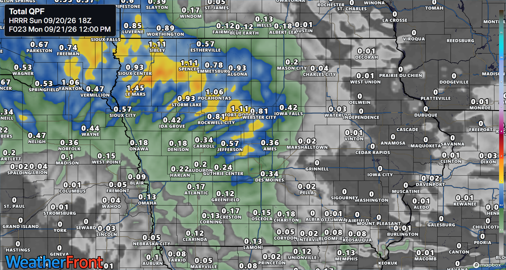
Rain will remain a common feature of Iowa’s weather through Monday night as an upper-level low-pressure system moves eastward across the region. This system is helping generate showers by lifting moist air through the atmosphere, allowing clouds and precipitation to develop. At the same time, drier air moving into the region from the northeast will limit how much moisture is available for additional rainfall. The result will be a prolonged period of cloudy and occasionally wet weather rather than another widespread heavy rainfall event. Northern Iowa will have the greatest opportunity to receive additional precipitation, although scattered showers may also develop farther south.
Rainfall is expected to become more widespread across portions of northern and northwestern Iowa Sunday afternoon and evening, with precipitation continuing overnight into Monday. Areas near the Minnesota border, including portions of northwest Iowa, will be closer to the more persistent rainfall associated with the approaching system. Farther south, showers will generally be lighter and more scattered, with some communities experiencing extended periods of cloudy weather between rounds of rain. A few thunderstorms may develop across northern Iowa, but the available atmospheric instability is limited, keeping the overall thunderstorm potential relatively low. Severe weather is not currently indicated as a significant concern with this system.
Rainfall totals will vary considerably depending on location, particularly across northern Iowa. Portions of central and northern Iowa could receive approximately two-tenths to one-half inch of additional rainfall through Monday night, with the greatest totals generally expected where multiple rounds of showers occur. Farther northwest, areas near the Iowa-Minnesota border could receive higher amounts, with a broader corridor of one-half inch to 1.5 inches possible across southeast South Dakota and into northern portions of northwest Iowa. Some locations in northwest Iowa could also receive around one-quarter inch of additional rainfall during the day Monday as the system gradually moves eastward. Meanwhile, eastern Iowa is expected to receive much lighter precipitation, generally less than one-quarter inch through the next 24 hours.
Rain chances will gradually decrease as the upper-level system moves away from Iowa, although the timing of improvement will vary across the state. Western portions of the region should begin seeing precipitation diminish during Monday, while showers could linger longer across central and eastern Iowa. Some lingering precipitation may continue into Monday night, with eastern Iowa potentially remaining cloudy and damp into early Tuesday morning. Rainfall coverage and intensity will depend on the exact track of the upper-level low and how much moisture remains available as it crosses the state. Confidence is relatively high that widespread heavy rainfall will not return with this particular system, although localized differences in rainfall totals remain possible.
Flooding Concerns Continue in Eastern Iowa
Although the threat of widespread heavy rainfall has diminished, flooding remains a concern in portions of eastern Iowa following the significant rainfall that occurred over the past several days. Several creeks have experienced elevated water levels, including Indian Creek in Linn County, where flooding was reported earlier Sunday. Water levels in some affected areas had stopped rising by Sunday morning, suggesting that conditions were beginning to improve. However, falling water levels do not necessarily mean that flooding has ended, particularly in low-lying areas where water may take additional time to drain. Residents near affected creeks and streams should continue monitoring local conditions as the remaining water moves through the drainage system.
Additional rainfall through Monday is expected to be considerably lighter than the precipitation responsible for the recent flooding. Much of eastern Iowa is forecast to receive less than one-quarter inch of rain during the next 24 hours, which should limit the potential for additional widespread flooding. However, portions of northeast Iowa remain more vulnerable because the ground is already saturated from previous rainfall. If localized rainfall totals exceed one inch, additional flooding could develop in areas where soils and waterways have little remaining capacity to absorb or carry more water. The likelihood of that amount of rain is relatively low, but the existing ground conditions warrant continued attention.
Travelers should remain alert for water covering roads, particularly near creeks, streams, and other low-lying locations that have experienced flooding. Even after rainfall ends, some roads may remain affected until water levels fall enough for normal travel to resume. Drivers should never attempt to cross a flooded roadway, as the depth of the water and the condition of the pavement beneath it may be difficult to determine. Conditions should gradually improve through Monday as the heaviest rainfall remains out of the forecast and water levels continue to recede. Anyone living or traveling near an affected waterway should check current flood warnings and local road conditions before heading out.
Monday Morning Fog Could Affect the Commute
Fog could become another concern across Iowa late Sunday night and into Monday morning as moisture remains trapped near the ground following the recent rainfall. Light winds, damp ground, and a cool lower atmosphere will create favorable conditions for fog to develop in portions of the state. The greatest concern will be during the early morning hours, when visibility could become reduced enough to affect the morning commute. Areas that experience additional rainfall overnight may be particularly susceptible to fog development, although the exact locations of the lowest visibility remain uncertain. Low clouds and pockets of mist may also contribute to poor visibility even where widespread fog does not develop.
Drivers heading to work or school Monday morning should allow additional travel time and prepare for changing visibility along their routes. Fog can develop unevenly, meaning visibility may be relatively good in one location before dropping considerably a short distance away. Using low-beam headlights, reducing speed, and increasing the distance between vehicles can help improve safety when traveling through fog. Motorists should also remain alert for wet pavement and areas where standing water may still be present following recent rainfall. Visibility should generally improve as the morning progresses, although persistent low clouds and damp conditions may continue through much of the day.
Fog may also become possible across portions of northwest Iowa late Monday night into Tuesday morning as moisture lingers near the surface. The extent of any additional fog will depend on how quickly the atmosphere dries out and whether cloud cover and winds remain favorable for its development. Confidence is higher in the potential for fog Monday morning than in the exact coverage of any fog that develops Tuesday morning. Travelers should monitor the latest local weather forecast before heading out, especially if their commute begins during the early morning hours. Conditions may vary considerably between communities, making current visibility observations particularly useful for planning travel.
Cooler Temperatures Bring an Early Taste of Fall
Iowa will experience a noticeable stretch of cooler weather as persistent cloud cover and northeast winds keep temperatures from warming significantly. Afternoon temperatures Sunday are expected to remain in the 60s across much of the state, with far southeast Iowa having a better opportunity to experience slightly warmer conditions. The combination of thick clouds and limited sunshine will prevent temperatures from climbing as much as they otherwise might during the afternoon. Cool air moving into the region from the northeast will reinforce the lower temperatures as the weather system continues moving across Iowa. These conditions will set the stage for an even cooler start to the workweek.
Monday is expected to be one of the coolest days of the week, with afternoon highs struggling to reach 60 degrees across much of Iowa. Many communities in central and northern Iowa may spend the afternoon in the upper 50s, particularly where clouds and showers remain persistent. Portions of western Iowa could reach the lower 60s, while eastern Iowa may experience highs ranging from the upper 50s into the lower or middle 60s. Northeast winds will add to the cool feel of the day, with portions of eastern Iowa experiencing sustained winds around 10 to 15 mph. Residents spending extended periods outdoors may want an additional layer, especially during the morning and evening hours.
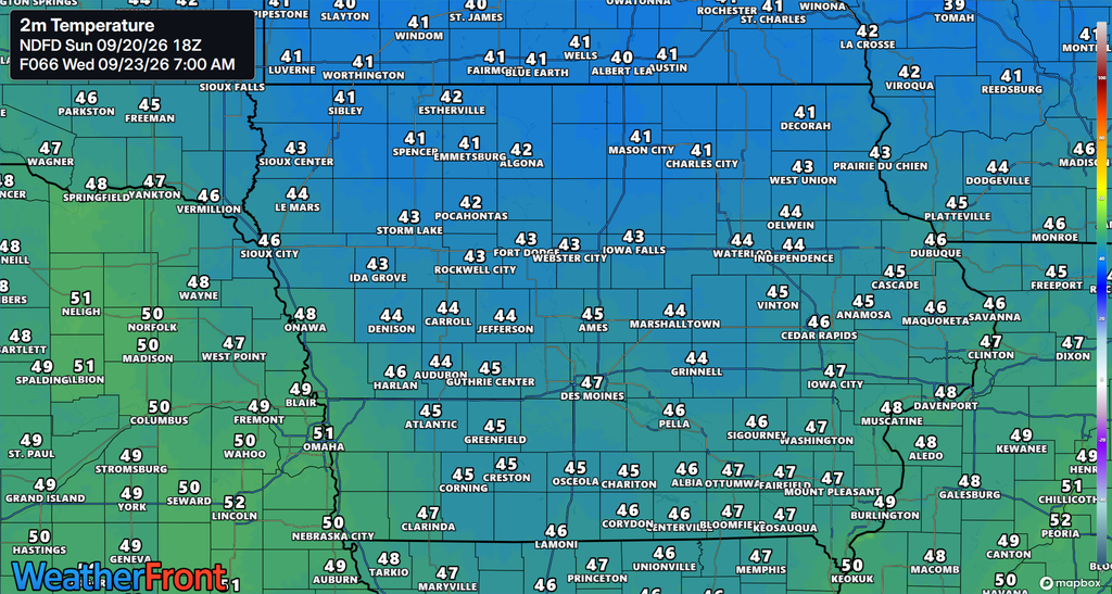
Overnight temperatures will also reflect the cooler weather pattern, with lows generally falling into the upper 40s and 50s through Monday night. As the atmosphere begins to dry out during the middle of the week, some locations could experience overnight temperatures in the 40s. These readings will provide a more noticeable early fall feel, particularly during the morning hours when temperatures are at their lowest. The cooler pattern is expected to persist through much of the week before temperatures gradually moderate heading toward next weekend. While the weather will feel considerably different from recent warmer conditions, the available forecast information does not indicate a widespread freezing threat during this period.
Sunshine Returns as Iowa Settles Into a Drier Midweek Pattern
A gradual improvement in Iowa’s weather is expected beginning Tuesday as the upper-level system responsible for the recent rainfall moves away from the state. High pressure positioned near the Great Lakes will help introduce a drier air mass, reducing the amount of moisture available for additional showers. However, the transition will not necessarily produce immediate sunshine across every part of Iowa. Lingering low clouds may remain in place during the first part of Tuesday, especially across areas that experience rain late Monday night. Conditions should gradually improve as the atmosphere dries out, allowing more breaks in the cloud cover.
Tuesday afternoon temperatures are expected to climb into the 60s across much of Iowa, with some locations remaining cooler where clouds persist. Western Iowa may experience highs in the middle 60s, while portions of eastern Iowa could see temperatures ranging from the middle 60s into the lower 70s during the middle of the week. Wednesday currently offers another opportunity for generally dry weather, with partly cloudy skies and comfortable afternoon temperatures expected across much of the state. Overnight lows will generally fall into the 40s and lower 50s, making mornings noticeably cooler than the afternoon hours. The combination of reduced rainfall and more sunshine should provide better conditions for outdoor activities and travel compared with the start of the week.
There is some uncertainty regarding how quickly clouds will clear across western Iowa and whether a few additional showers could develop during the transition to the drier pattern. A weak disturbance moving through the region Tuesday night into Wednesday could produce isolated showers in portions of western Iowa as slightly warmer air begins returning to the region. However, the broader weather pattern continues to favor a substantial reduction in rainfall across the state during the middle of the week. Confidence is relatively high that Tuesday and Wednesday will offer an improvement over the persistent damp conditions expected through Monday. The exact amount of sunshine will depend on how quickly the remaining low-level moisture clears out.
Rain Chances Return Later This Week
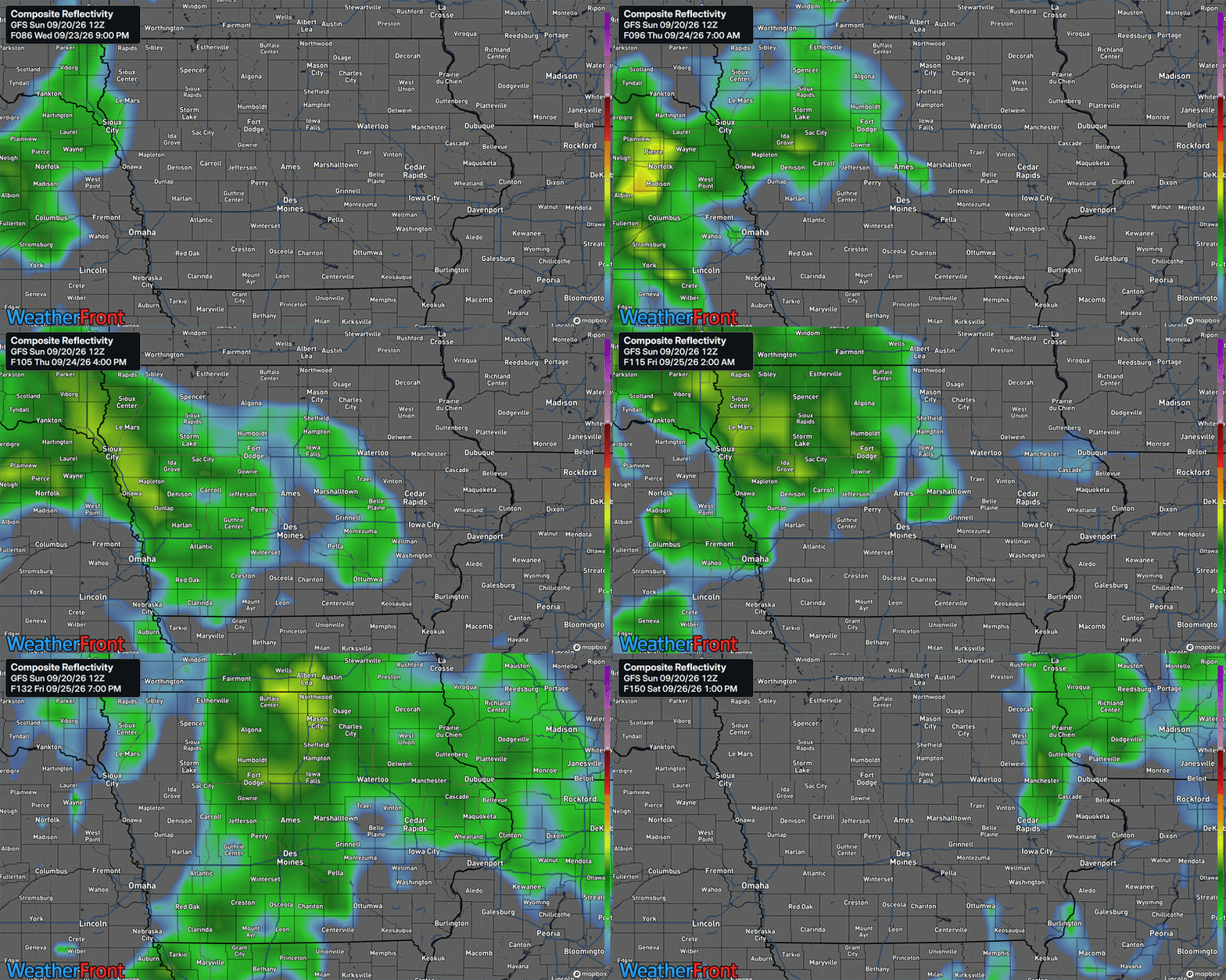
The next opportunity for more widespread rainfall is expected to develop later in the week as the weather pattern begins shifting across the Central Plains. High pressure will gradually move away from the region, allowing southerly winds to return and transport additional moisture northward. At the same time, disturbances moving into the western United States will begin influencing the weather across the central part of the country. These changes will create a more favorable environment for showers and thunderstorms to develop as the week progresses. Western Iowa is expected to be among the first areas affected as the next system approaches from the west.
Rain chances could begin returning to portions of western Iowa as early as Wednesday night into Thursday, although the timing and coverage remain uncertain. Additional opportunities for showers and thunderstorms are expected Thursday through the weekend as the atmosphere becomes more active. The greatest initial potential for precipitation appears to favor western Iowa, with rain chances potentially expanding farther east as individual disturbances move through the region. However, the exact track and timing of these systems will determine which communities receive rainfall and how much precipitation ultimately develops. Residents planning outdoor activities later in the week should continue monitoring the forecast as the timing of individual rain chances becomes clearer.
At this time, the available forecast information does not indicate a significant severe weather threat or widespread heavy rainfall event with the late-week system. Atmospheric conditions will continue evolving as moisture returns to the region, and the potential for thunderstorms will depend on how much instability develops ahead of the approaching disturbances. Forecast confidence is higher that rain chances will return than it is in the exact timing, location, or intensity of individual showers and thunderstorms. There is also uncertainty regarding how far east the precipitation will spread during the first part of the weekend. Additional forecast updates will help determine whether the greatest rainfall potential remains concentrated across western Iowa or expands across a larger portion of the state.
Temperatures Gradually Warm Heading Into Next Weekend
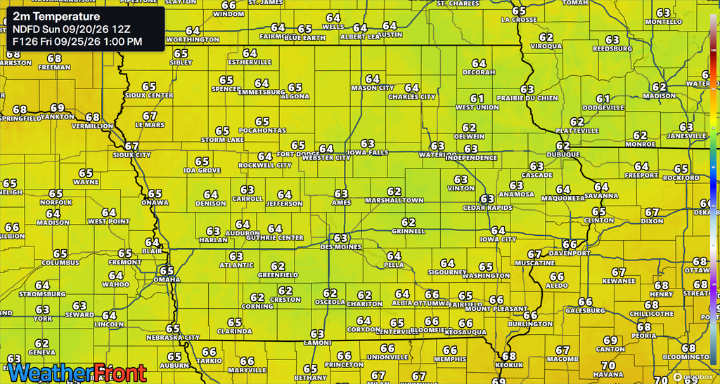
Although the middle of the week will feature cool temperatures and a more noticeable fall feel, a gradual warming trend is expected as the weekend approaches. Winds will begin shifting toward a more southerly direction across portions of the region, allowing somewhat warmer air to move back into Iowa. This change will be most noticeable across western Iowa, where afternoon temperatures could climb into the upper 60s and lower 70s by Friday and Saturday. Eastern Iowa may also experience a gradual increase in temperatures, with highs potentially reaching the upper 60s to middle 70s by next weekend. The exact degree of warming will depend on cloud cover and the timing of any additional rainfall.
The warming trend will not necessarily mean that sunny weather will return for the entire weekend. Increasing moisture and the approach of additional weather disturbances could produce periods of cloud cover and scattered showers, limiting afternoon temperatures in some locations. Communities that experience more sunshine will have a better opportunity to reach the warmer end of the forecast temperature range. Meanwhile, areas that remain cloudy or experience repeated showers may struggle to warm as much during the afternoon. Overall, temperatures are expected to move closer to seasonal averages by the end of the week, particularly across western and northwestern Iowa.
Looking Ahead: What to Expect Across Iowa This Week
Iowa’s weather forecast for the coming days features a transition from persistent rainfall and cloudy skies toward a cooler and generally drier early fall pattern. Showers will continue through Monday night, with northern Iowa experiencing the greatest opportunity for additional rainfall and Monday morning fog potentially affecting travel across portions of the state. Existing flooding in eastern Iowa will remain an important concern in areas where waterways are still elevated, although the threat of additional widespread heavy rainfall has diminished. Temperatures will remain cool through the middle of the week, with Monday likely to be among the coolest days as highs struggle to reach 60 degrees in many communities. Conditions should gradually improve Tuesday and Wednesday as the atmosphere dries out and more sunshine becomes possible.
Looking toward the end of the week, the next weather system could bring additional showers and thunderstorms beginning Thursday, particularly across western Iowa. Rain chances may continue into next weekend, although the timing and coverage of individual rounds of precipitation remain uncertain. Temperatures will gradually moderate as warmer air returns, with afternoon highs potentially reaching the upper 60s and lower 70s across much of the state by Saturday. The primary forecast details to monitor over the coming days will be the timing of the late-week rainfall, how far east the precipitation spreads, and whether any changes develop in the thunderstorm potential. For now, the overall pattern favors a cool and damp start to the week, improving weather during the middle of the week, and a return to more unsettled conditions as the weekend approaches.
Stay connected with IowaWeather.com for the latest Iowa weather updates, local weather forecasts, and changing weather conditions throughout the week. Download the ISCN Weather app to follow the latest weather radar, monitor developing rain chances, and stay informed about weather conditions in your community.