Iowa Weather: Thunderstorms Tuesday, Widespread Rain Thursday, and Frost Possible This Weekend
Iowa’s stretch of unusually warm October weather is coming to an end as a series of weather systems brings thunderstorms, widespread rainfall, and eventually a significant drop in temperatures. The transition begins Monday night as a cold front moves across the state, setting the stage for a much different weather pattern through the remainder of the week. While the first round of thunderstorms Tuesday night could produce isolated severe weather, a second system arriving Wednesday night into Thursday will bring more widespread rain.
The biggest temperature changes will arrive late in the week when a stronger cold front pushes through Iowa, sending afternoon highs into the 50s and 60s. Overnight temperatures could fall into the 30s by Friday night, raising the possibility of frost across portions of the state Saturday morning. For some communities, particularly across northern Iowa, this could be one of the more significant cold spells of the fall season so far.
The Iowa weather forecast also features some important differences from north to south, especially with Tuesday’s thunderstorm potential. Southern Iowa will remain closer to the warmer, more humid air needed to support stronger thunderstorms, while northern Iowa will generally experience cooler and quieter conditions until the more widespread rain arrives later in the week.
Cold Front Brings Changes Monday Night Into Tuesday
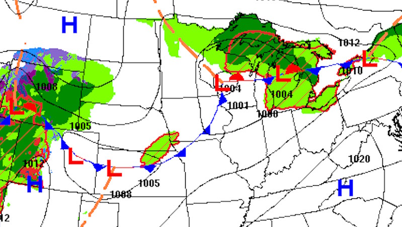
A cold front moving southeast across Iowa Monday evening will gradually bring an end to the summer-like warmth that has dominated the region. The front will move through much of the state overnight, shifting winds toward the north and allowing cooler air to spread southward. Most communities will remain dry during the overnight hours, although a few isolated showers or thunderstorms cannot be ruled out across far southern and southwestern Iowa. Cloud cover will increase in some areas as moisture begins to gather along and just north of the boundary. Overnight temperatures will vary considerably depending on when the front passes, with cooler readings across northern Iowa and relatively mild conditions lingering farther south.
Tuesday’s weather will feature a noticeable temperature difference across the state as the cold front slows and eventually stalls near northern Missouri. Much of northern and central Iowa will experience temperatures in the 60s and 70s, although some central locations could still approach 80 degrees before cooler air becomes more established. Southern Iowa, especially near the Missouri border, may remain considerably warmer, with some locations potentially reaching the lower 80s. Humidity will also be more noticeable across southern Iowa, where moisture will continue to increase ahead of an approaching disturbance. This contrast between the cooler air to the north and warmer, more humid conditions to the south will play an important role in determining where thunderstorms develop later Tuesday.
Strong to Severe Thunderstorms Possible Tuesday Evening and Overnight
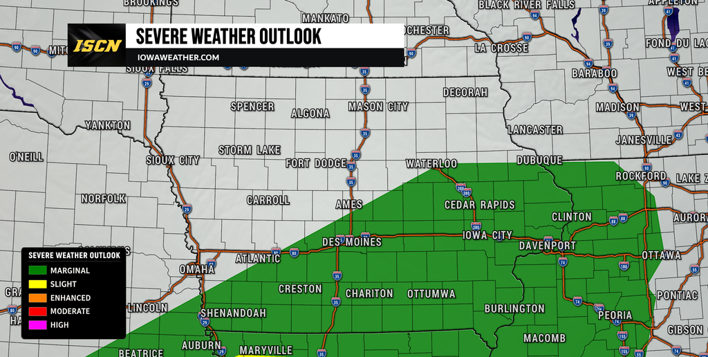
Thunderstorm chances will increase Tuesday afternoon and evening as a developing low-pressure system over the Central Plains interacts with the stalled frontal boundary near Iowa. Warm, humid air moving northward will provide fuel for thunderstorms, while stronger winds higher in the atmosphere will help organize some of the developing storms. The greatest potential for stronger thunderstorms will generally remain south of Iowa, closer to the warmest and most unstable air across Kansas and Missouri. However, portions of southern Iowa will be close enough to the boundary that a few strong to severe thunderstorms remain possible. The Storm Prediction Center has outlined a Marginal Risk, level 1 of 5, for portions of the region, indicating that isolated severe thunderstorms could develop.
The primary severe weather concerns across Iowa will be large hail and isolated damaging wind gusts, particularly across the southern counties. Some thunderstorms may develop farther west during the afternoon before spreading east and northeast toward Iowa during the evening and overnight hours. The greatest concern will generally be across southern and southeastern Iowa, including areas near and south of Highway 34, although storms could extend farther north into central and eastern Iowa. The overall severe weather threat should remain limited compared to areas farther south, where stronger instability will support more organized thunderstorms.
Another Round of Widespread Rain Expected Wednesday Night Into Thursday
After the first round of thunderstorms moves through, Iowa should experience a temporary reduction in rainfall chances Wednesday, particularly during the afternoon. Some lingering showers will remain possible during the morning, especially across southern and eastern Iowa, but much of the state could experience a period of relatively quiet weather. Afternoon temperatures will generally settle into the 60s and lower 70s, a noticeable change from the unusually warm conditions earlier in the week. Clouds may remain widespread in some locations as moisture continues to circulate through the region. This quieter period will be temporary, however, as a stronger weather system approaches from the southwest.
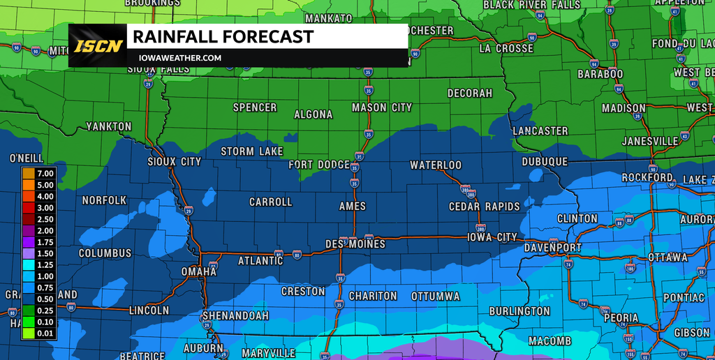
Rain chances will increase again Wednesday night as a larger upper-level low-pressure system moves out of the southwestern United States and toward the Central Plains. Unlike Tuesday’s more concentrated thunderstorm threat, this system is expected to bring a broader area of showers across Iowa, with widespread precipitation likely Thursday. Rain chances are particularly high across central and eastern Iowa, where probabilities reach approximately 70% to 90% in some locations. Northern Iowa will also have a better opportunity for measurable rainfall with this system, although exact totals will depend on the storm’s track. The greatest uncertainty involves how far north the more persistent rainfall will extend, especially across the northeastern portion of the state.
Thunderstorms may accompany Thursday’s rainfall, but widespread severe weather is not currently anticipated. The atmosphere will have less instability available than during Tuesday’s storm potential, reducing the likelihood of organized severe thunderstorms. Most areas should receive manageable rainfall amounts, although some locations could experience heavier downpours if thunderstorms repeatedly move across the same area. Forecast guidance suggests many locations could receive less than one-half inch from individual rounds of precipitation, with locally higher totals possible. Widespread flash flooding is not currently the primary concern, but isolated ponding on roads and poor-drainage areas will remain possible during heavier rainfall.
Strong Cold Front Brings Much Cooler Weather Friday
The second half of the week will feature another significant weather change as a strong cold front moves through Iowa late Thursday into Friday. This front will be associated with a larger storm system tracking toward the Great Lakes, allowing a much colder air mass from Canada to spread into the Midwest. Rain should gradually end from west to east as the system departs, with drier conditions becoming more widespread by Friday. Temperatures will struggle to recover during the afternoon, with highs generally reaching only the 50s to lower 60s across much of Iowa. Compared to the summer-like warmth experienced at the beginning of the week, the difference will be substantial.
Friday will also likely be a breezy to windy day as colder air moves into the region behind the departing storm system. Gusty northwest winds could make conditions feel even cooler, especially across open areas of northern and western Iowa. The combination of falling humidity, stronger winds, and drying vegetation may also increase the potential for agricultural field fires, even with the cooler temperatures. Farmers and anyone working with equipment that can produce sparks should remain aware of changing wind conditions and local fire restrictions. By Friday evening, winds should begin to ease in some locations as high pressure builds toward the region, setting the stage for a potentially cold night.
Frost Possible Friday Night Into Saturday Morning
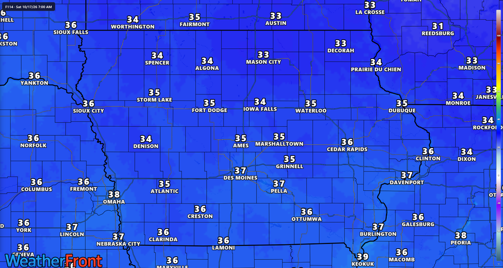
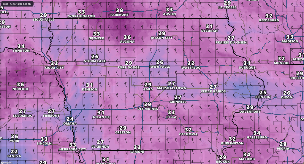
One of the more important developments in the extended Iowa weather forecast will be the potential for frost late Friday night into Saturday morning. A colder air mass settling over the region could allow overnight temperatures to fall into the 30s across much of Iowa, with some northern locations potentially dropping closer to freezing. The greatest frost potential currently appears to be across northern and northeastern Iowa, including communities along and north of Highway 30. However, portions of central and western Iowa could also experience frost if skies clear and winds become light enough overnight. For sensitive vegetation, this could become an important weather concern as the weekend approaches.
Frost formation depends on more than the temperature shown in a forecast. Clear skies allow heat to escape from the ground more efficiently, while light winds permit colder air to collect near the surface. If winds remain elevated Friday night, temperatures may stay slightly warmer and frost development could become less widespread. Forecast models continue to show differences in the strength of the incoming cold air and how quickly winds will diminish, so confidence in the exact coverage of frost remains moderate. A more widespread freeze is possible in colder areas of the Upper Midwest, but the extent of freezing temperatures within Iowa remains uncertain.
Residents with gardens, outdoor plants, or temperature-sensitive vegetation should monitor the forecast closely over the next several days. While not every community will necessarily experience frost, the potential is high enough to begin considering protective measures for vulnerable plants. Areas sheltered from the wind and low-lying rural locations may become colder than nearby urban neighborhoods. Frost can sometimes develop even when the official air temperature remains a few degrees above 32 degrees, especially on exposed surfaces. Additional forecast updates should provide a clearer picture of which Iowa communities face the greatest frost risk as Friday night approaches.
Weekend Forecast: Cool Saturday, Then a Gradual Warmup
Saturday should bring a return to quieter weather across Iowa as high pressure settles over the region following the late-week cold front. Morning temperatures will be chilly, particularly where skies clear and winds become light enough for frost development. Afternoon highs should recover into the 50s and lower 60s, keeping conditions noticeably cooler than the unusually warm weather earlier in the week. Sunshine should become more widespread as the departing storm system moves farther east and drier air settles into the state. For outdoor activities, Saturday should generally offer favorable weather conditions, although a jacket will likely be needed during the morning and evening hours.
Temperatures are expected to begin recovering Sunday as winds turn more southerly and warmer air gradually returns to the Midwest. Afternoon highs could climb back into the 60s across much of Iowa, with some locations potentially approaching the 70s early next week. The overall weather pattern appears likely to become quieter and drier through much of the weekend, offering a break from the multiple rounds of rainfall earlier in the week. There are some early indications that another weak disturbance could bring additional rain chances early next week, but confidence in that possibility remains low. For now, the most likely outcome is a gradual warming trend with temperatures returning closer to or slightly above seasonal averages.
Stay connected with IowaWeather.com for the latest Iowa weather forecast, live weather radar, severe weather updates, and changing conditions throughout the week. You can also follow the Iowa Storm Chasing Network and download the ISCN Weather app for weather information wherever you go.