Iowa Weather Forecast: Thunderstorms Tonight, Warm and Windy Weekend Ahead Before Fall Temperatures Return
Iowa is in for another stretch of unusually warm October weather, but a few changes are on the horizon. Showers and thunderstorms will return to portions of the state later today and tonight, followed by temperatures climbing into the 80s Friday and Saturday. Gusty winds and dry conditions could also increase fire weather concerns this weekend before a cold front brings more seasonable temperatures and additional rain chances next week.
Pleasant Thursday Across Iowa Before Rain Arrives
Thursday is shaping up to be another pleasant October day across much of Iowa, with afternoon temperatures climbing into the 70s. Western and southwestern portions of the state could see temperatures approaching the lower 80s, while northern and eastern Iowa will generally remain a little cooler.
While much of the state will remain dry during the daytime hours, attention will turn toward an approaching weather system that could produce scattered showers and thunderstorms beginning Thursday afternoon in northwestern Iowa.
Showers and Thunderstorms Expected Thursday Night Into Friday
A developing area of low pressure and an advancing warm front will bring increasing moisture into Iowa Thursday evening and overnight, setting the stage for scattered showers and thunderstorms.
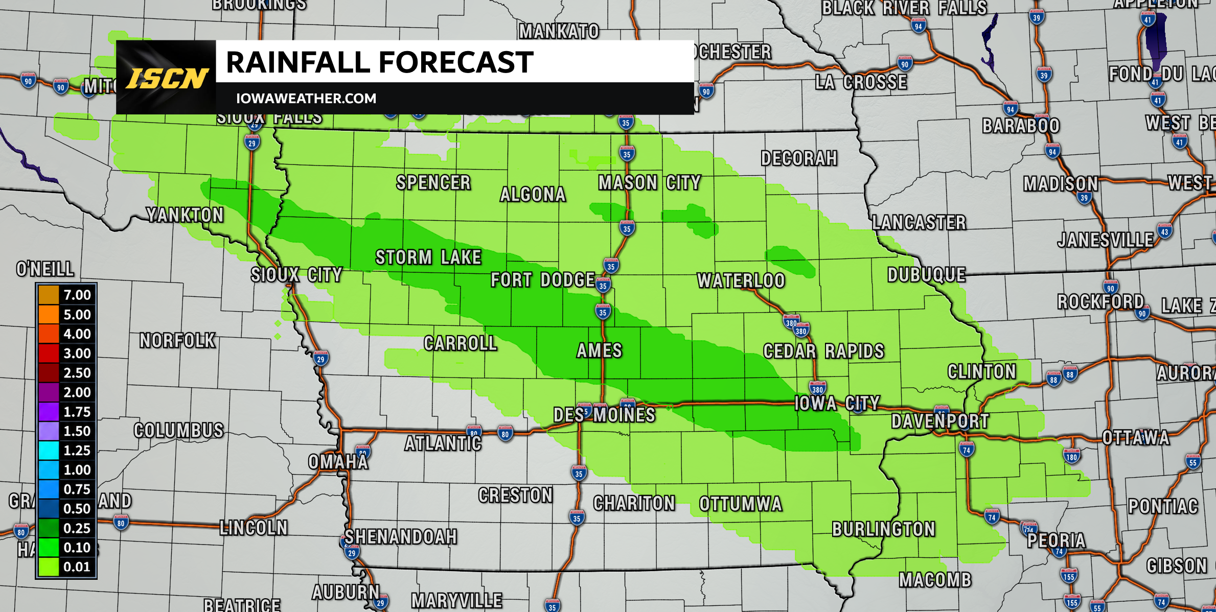
The first activity could develop across northwestern Iowa Thursday afternoon, with additional showers and thunderstorms spreading into central and eastern portions of the state overnight. The greatest coverage of precipitation is expected across central Iowa late Thursday night into Friday morning. Showers and isolated thunderstorms could continue into Friday afternoon across portions of eastern Iowa before gradually moving out of the region.
How Much Rain Could Iowa Receive?
Rainfall amounts will vary considerably depending on where showers and thunderstorms develop.
Across central Iowa, many locations that receive precipitation could pick up between 0.10 and 0.50 inches. A few isolated locations could see amounts exceeding one inch if heavier thunderstorms repeatedly move across the same area, although this currently appears to be a less likely scenario.
Rainfall totals across eastern Iowa will generally be lighter, with many locations receiving around a tenth of an inch or less. Some areas could see locally higher totals.
Northwestern and western Iowa may also experience lighter precipitation amounts, with some locations receiving little or no measurable rainfall.
Overall, widespread heavy rainfall and flooding are not expected.
Temperatures Climb Into the 80s Friday and Saturday
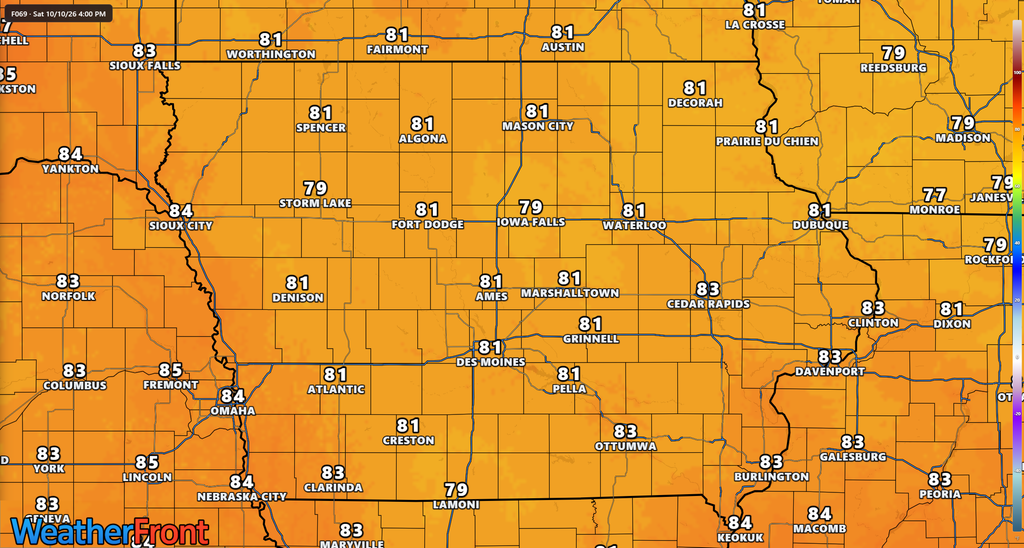
Following the departure of Friday morning’s precipitation, a surge of warmer air will push temperatures well above normal for early October.
Friday afternoon, southern and western Iowa could reach the lower to middle 80s, while northern portions of the state remain in the middle to upper 70s. A warm front positioned across central Iowa may create noticeable temperature differences over relatively short distances. Cloud cover and lingering precipitation could also influence how quickly temperatures warm Friday afternoon.
Saturday is expected to be one of the warmest days of the forecast period, with widespread highs in the 80s across much of Iowa. In some locations, temperatures could run approximately 15 to 20 degrees above normal for this time of year.
The unusual warmth will be accompanied by increasing southerly winds, making Saturday a day to watch for more than just the temperatures.
Strong Winds Could Increase Fire Danger Saturday
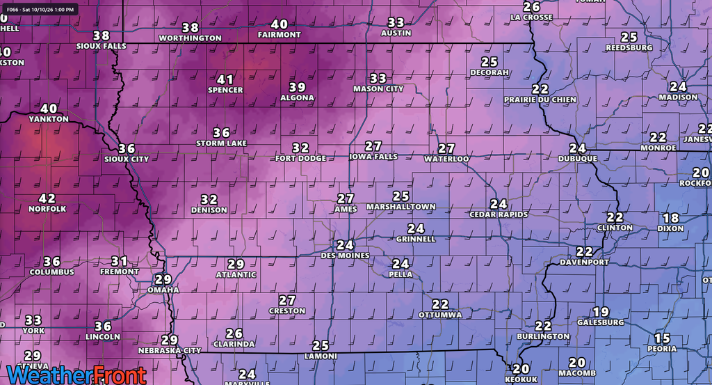
One of the more significant weather concerns heading into the weekend will be the combination of warm temperatures, gusty winds, and relatively low humidity. Southerly winds are expected to increase substantially Saturday, with gusts of 30 to 40 mph possible across portions of Iowa.
The strongest winds are currently expected across northwestern Iowa, where isolated gusts could approach 45 mph or potentially higher. These conditions could contribute to elevated fire weather concerns, particularly across agricultural areas where vegetation and crop residue have dried out.
Harvesting activities may also increase the potential for accidental field fires when strong winds and dry conditions are present. Farmers and others working outdoors should exercise additional caution with machinery and equipment that could generate sparks. Outdoor burning should be avoided when conditions are favorable for rapid fire spread.
The exact level of fire danger will depend on how low humidity values fall and how dry vegetation becomes heading into Saturday.
Cooler Weather Returns to Iowa Early Next Week
The unusually warm weather will not last indefinitely. Sunday should remain relatively mild, with afternoon temperatures generally reaching the upper 70s across much of Iowa. Winds should also begin to decrease compared to Saturday.
A cold front is expected to move through the region late Sunday into Monday or Monday night, with timing varying across the state. The front will bring a noticeable change in temperatures, along with another opportunity for precipitation.
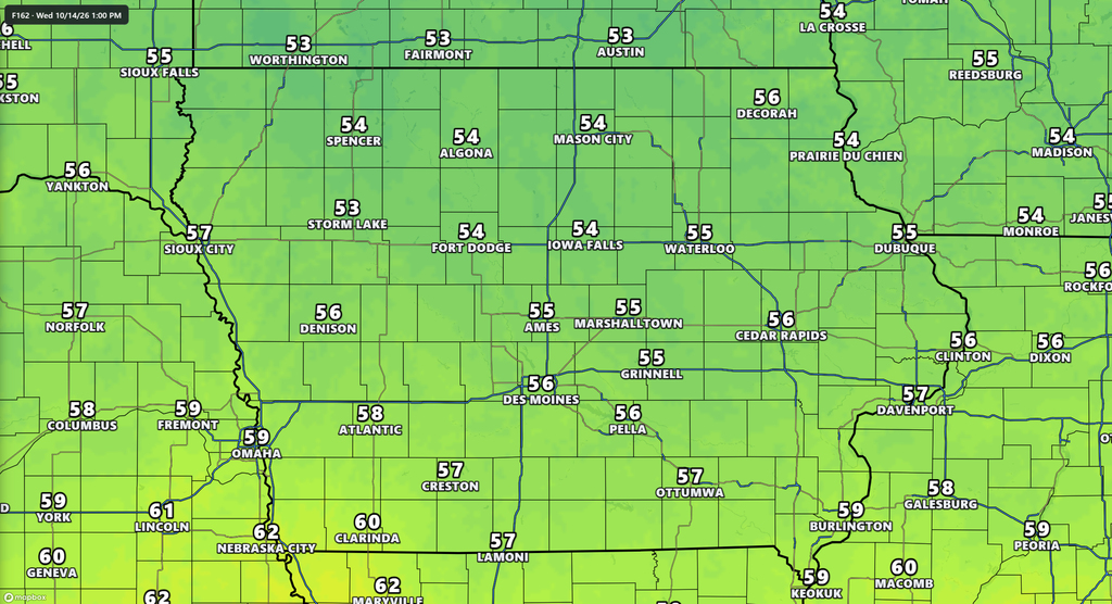
Northern and northeastern Iowa currently have some of the better chances for showers around Monday, although much of the state could remain dry during the initial frontal passage. By Tuesday and Wednesday, cooler air is expected to settle across Iowa, with afternoon highs generally returning to the 50s and 60s.
This would represent a significant temperature drop compared to the warmth expected Friday and Saturday.
Could More Active Weather Develop Later Next Week?
Forecast guidance continues to indicate the potential for a more active weather pattern developing across the central United States toward the middle and latter portions of next week. An approaching upper-level weather system could bring additional opportunities for showers and thunderstorms across Iowa.
Some forecast guidance also suggests that atmospheric conditions could become favorable for a stronger fall storm system somewhere across the Great Plains later next week. However, considerable uncertainty remains regarding the development, timing, and track of these systems.
It is too early to determine whether Iowa will experience any significant thunderstorms or severe weather next week. The overall pattern is worth monitoring, and forecast confidence should improve over the coming days.
Iowa Five-Day Allergy Forecast: Pollen Levels Increase Sunday
Fall allergy sufferers may notice some changes heading into the weekend, particularly on Sunday when pollen levels are expected to increase across much of Iowa.
The primary allergens currently affecting the state include ragweed, chenopods, and sagebrush.
The following five-day allergy forecast covers Thursday, October 8, through Monday, October 12.
| City | Thu | Fri | Sat | Sun | Mon |
|---|---|---|---|---|---|
| Des Moines | 4.5 | 3.3 | 3.2 | 6.2 | 5.3 |
| Mason City | 3.7 | 2.1 | 2.0 | 5.6 | 4.9 |
| Council Bluffs | 4.9 | 5.2 | 5.4 | 6.7 | 5.5 |
| Davenport | 4.9 | 4.4 | 3.1 | 5.4 | 5.2 |
| Dubuque | 3.7 | 3.3 | 2.1 | 4.6 | 4.4 |
Allergy index categories:
- Low: 0–2.4
- Low-medium: 2.5–4.8
- Medium: 4.9–7.2
- Medium-high: 7.3–9.6
- High: 9.7–12.0
Sunday currently appears to be the most challenging day for allergy sufferers, with medium pollen levels expected across Des Moines, Mason City, Council Bluffs, and Davenport.
Council Bluffs is forecast to experience some of the highest allergy levels among the five cities, reaching 6.7 on Sunday.
Those sensitive to fall pollen may want to limit prolonged outdoor exposure during periods of higher pollen concentrations.
Iowa Continues Losing Daylight as October Progresses
Along with the changing temperatures, another sure sign of fall is becoming increasingly noticeable: earlier sunsets. Iowa is now experiencing approximately 11 hours and 25 minutes of daylight each day, with sunset occurring around 6:45 p.m.
By the end of October, sunset will occur closer to 6 p.m., making evening daylight increasingly limited. The transition away from Daylight Saving Time will bring another noticeable shift in sunset times in early November.
Stay ahead of Iowa’s changing weather by downloading the free ISCN Weather app for the latest forecasts and weather alerts, and visit IowaWeather.com for continuing statewide weather coverage.