Widespread Freeze Warnings Issued Across Iowa as Temperatures Could Drop Into the 20s Saturday Morning
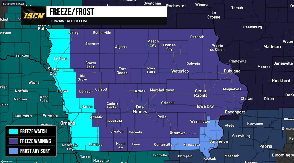
A widespread round of freezing temperatures is expected across Iowa early Saturday morning, prompting the National Weather Service to issue Freeze Warnings, Freeze Watches, and Frost Advisories for the entire state. Temperatures are forecast to fall into the upper 20s and lower 30s overnight Friday into Saturday, potentially bringing an end to the growing season for many locations.
The coldest temperatures are expected across northern and northeastern Iowa, where some communities could see overnight lows dip into the middle 20s. Meanwhile, portions of southern and southeastern Iowa are expected to experience temperatures closer to the freezing mark.
Freeze Warnings Cover Much of Iowa
Freeze Warnings have been issued for a large portion of central, northern, eastern, and northwestern Iowa, effective from 1 a.m. until 9 a.m. Saturday, October 17.
The National Weather Service is forecasting temperatures as low as 29 degrees across much of central Iowa, including Des Moines, Ames, Fort Dodge, Mason City, Waterloo, Marshalltown, Carroll, and surrounding communities. Farther southeast, temperatures could drop to around 31 degrees in Ottumwa and surrounding portions of Wapello County.
Across eastern Iowa, including Cedar Rapids, Iowa City, Dubuque, Davenport, Clinton, and Burlington’s surrounding region, temperatures are expected to fall to around 30 degrees in areas under Freeze Warnings. Burlington itself is under a Frost Advisory.
Some of the coldest conditions are anticipated in northeastern Iowa, where the National Weather Service is forecasting temperatures as low as 26 degrees. Communities including Decorah, Cresco, Waukon, Charles City, and Oelwein are included in the Freeze Warning.
Northwestern Iowa communities, including Spencer, Spirit Lake, Storm Lake, Cherokee, and Sheldon, are also under Freeze Warnings, with temperatures potentially dropping to 29 degrees.
These temperatures could damage or kill sensitive vegetation, including flowers, garden plants, and crops that have not yet been harvested.
Freeze Watches Continue Across Western Iowa
While much of the state is under Freeze Warnings, portions of western and southwestern Iowa remain under Freeze Watches as forecasters monitor the potential for freezing temperatures.
Communities including Sioux City, Le Mars, Orange City, Rock Rapids, Council Bluffs, Glenwood, Harlan, Red Oak, and Clarinda are among the locations under Freeze Watches for late Friday night into Saturday morning.
Temperatures in these areas could fall as low as 29 to 32 degrees. A Freeze Watch indicates that freezing temperatures are possible, but there is still some uncertainty regarding the extent or severity of the freezing conditions.
Residents in these areas should continue monitoring the forecast, as Freeze Watches could be upgraded to Freeze Warnings if confidence in freezing temperatures increases.
Frost Advisories Issued for Portions of Southern and Southeastern Iowa
Frost Advisories have been issued for several counties in far southern and southeastern Iowa, where temperatures are expected to remain near or just above freezing.
The advisories include Davis, Van Buren, Lee, Henry, Des Moines, and Louisa counties, affecting communities such as Bloomfield, Keosauqua, Fort Madison, Mount Pleasant, Burlington, and Wapello.
Temperatures are forecast to fall to around 32 to 33 degrees, allowing frost to develop on exposed surfaces.
Although temperatures may not fall substantially below freezing in these locations, widespread frost could still damage or kill sensitive outdoor vegetation if precautions are not taken.
The Frost Advisories are in effect from 1 a.m. until 9 a.m. Saturday.
What Is the Difference Between a Freeze Warning, Freeze Watch, and Frost Advisory?
The National Weather Service issues these alerts to help residents prepare for potentially damaging cold temperatures.
- Freeze Warning: Issued when freezing temperatures are expected and could damage or kill sensitive vegetation.
- Freeze Watch: Issued when conditions are favorable for freezing temperatures, but uncertainty remains about whether they will occur.
- Frost Advisory: Issued when temperatures and atmospheric conditions are favorable for frost development that could damage sensitive plants.
Protect Plants and Outdoor Plumbing Before Temperatures Drop
With freezing temperatures expected across much of Iowa, residents are encouraged to take precautions before heading to bed Friday evening.
Tender plants and flowers should be brought indoors when possible. Plants that cannot be moved should be covered with frost cloths, blankets, or other protective materials to help reduce exposure to the cold.
Gardeners should also consider harvesting any remaining sensitive produce, including tomatoes and peppers, before freezing temperatures arrive.
Homeowners should disconnect garden hoses and consider protecting exposed outdoor plumbing, especially in areas where temperatures are expected to fall well below freezing.
Coldest Conditions Expected Around Sunrise Saturday
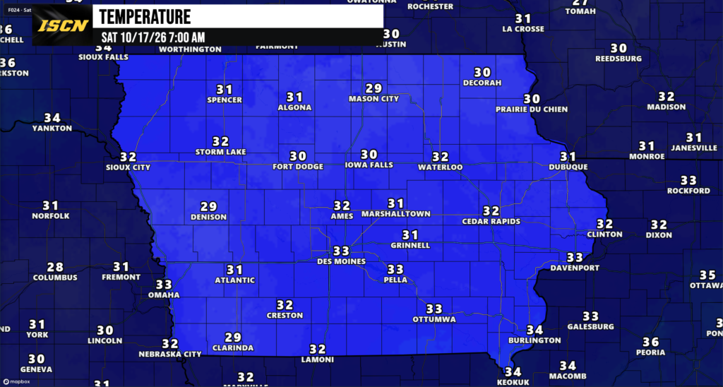
Temperatures are expected to fall throughout Friday night, with the coldest readings generally occurring during the early morning hours Saturday.
Although temperatures should recover after sunrise, several hours of near-freezing or sub-freezing conditions could be enough to damage unprotected vegetation.
Residents across Iowa should monitor the latest forecast and any updates to National Weather Service alerts, particularly in western Iowa, where Freeze Watches remain in effect.
Stay with IowaWeather.com and the Iowa Storm Chasing Network for the latest forecast information and weather updates across Iowa as the colder temperatures move into the state.