Freeze Watch Issued for Much of Iowa as Temperatures Could Drop Into the 20s Saturday Morning
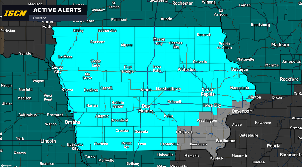
Much of Iowa could experience a widespread freeze this weekend as colder air moves into the region, bringing some of the lowest temperatures of the fall season. The National Weather Service has issued a Freeze Watch for much of Iowa from late Friday night, October 16, through Saturday morning, October 17, with temperatures potentially falling into the upper 20s and lower 30s.
The watch covers a large portion of the state, including central, northern, western, and eastern Iowa, while a small portion of southeast Iowa is not currently included. Temperatures could fall as low as 30 degrees across much of the watch area, with portions of northeast Iowa potentially reaching 27 degrees.
These temperatures could result in a widespread freeze, potentially damaging or killing sensitive vegetation, remaining crops, and unprotected outdoor plumbing.
How Cold Will Temperatures Get Across Iowa?
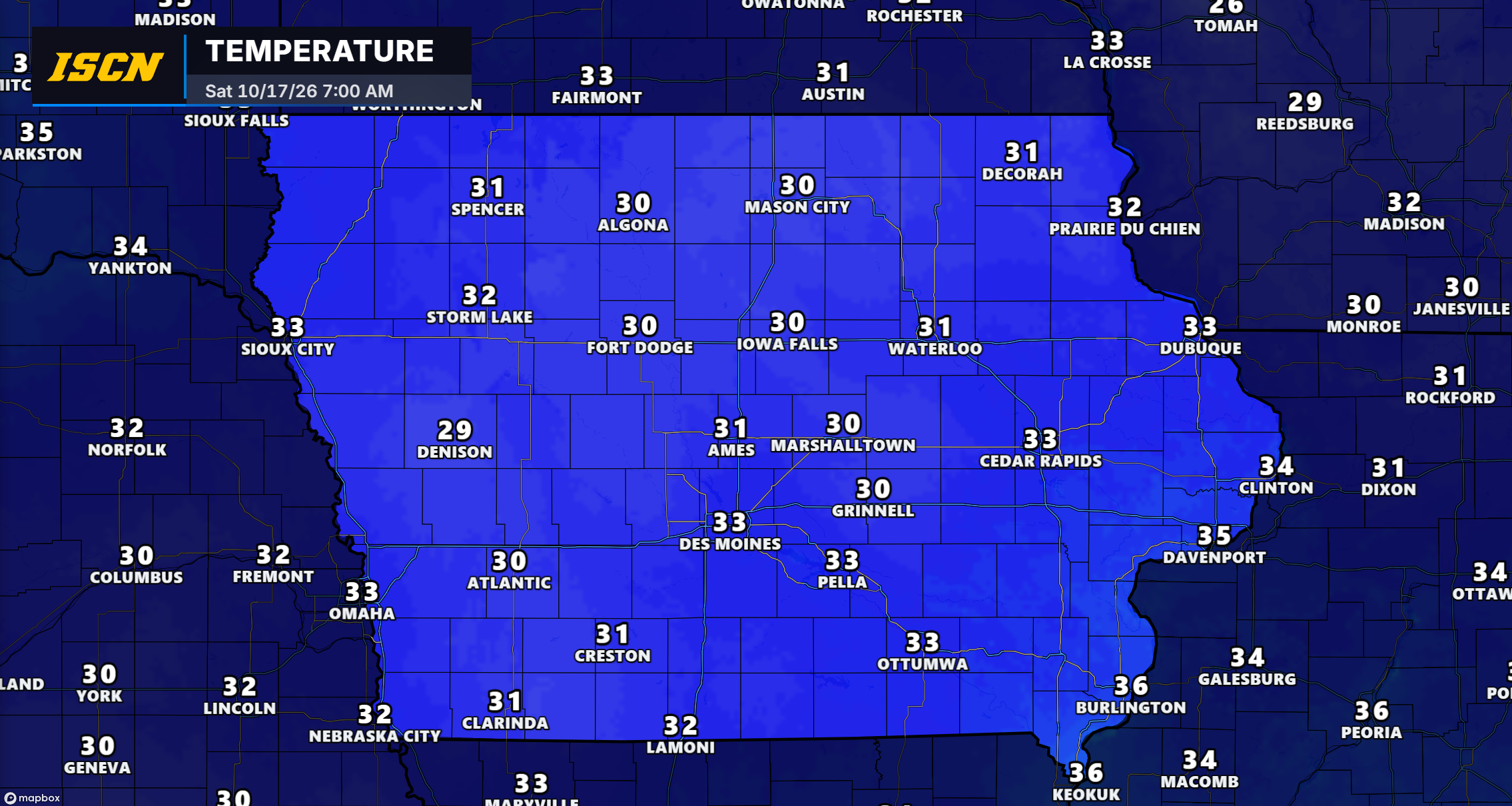
The coldest temperatures are expected late Friday night into early Saturday morning as colder air settles across the state.
According to the National Weather Service, temperatures could fall to around 30 degrees across much of central, western, southern, and eastern Iowa. Northeast Iowa could experience some of the coldest conditions, with temperatures potentially dropping into the upper 20s.
Communities including Des Moines, Ames, Cedar Rapids, Iowa City, Waterloo, Dubuque, Mason City, Fort Dodge, Sioux City, and Council Bluffs are among the locations included in the Freeze Watch.
In northeast Iowa, including areas around Decorah, Cresco, Waukon, and Charles City, temperatures could fall as low as 27 degrees.
While freezing temperatures are possible across much of Iowa, not every community will necessarily experience the same conditions. Local temperature differences could determine whether an area experiences frost, a light freeze, or more significant freezing conditions.
When Will the Freeze Watch Be in Effect?
The Freeze Watch is scheduled to begin early Saturday morning, although temperatures will begin falling Friday evening.
For most of the watch area, the National Weather Service has established the following timeframe:
- Begins: 1:00 a.m. CDT Saturday, October 17
- Ends: 9:00 a.m. CDT Saturday, October 17
Portions of western and northwestern Iowa have a slightly earlier expiration time of 8:00 a.m. CDT.
The greatest concern will be during the overnight and early morning hours when temperatures typically reach their lowest levels.
Temperatures are expected to recover after sunrise Saturday, reducing the immediate threat of freezing conditions.
What Is the Difference Between a Freeze Watch and a Freeze Warning?
A Freeze Watch is issued when conditions are favorable for temperatures to fall below freezing, potentially causing damage to sensitive vegetation and crops.
The issuance of a watch does not guarantee freezing temperatures will occur at every location. Instead, it indicates that the potential is significant enough for residents to begin taking precautions.
A Freeze Warning is issued when freezing temperatures are expected with greater confidence.
As the weekend approaches and forecast confidence increases, portions of the current Freeze Watch could be upgraded to a Freeze Warning.
Even locations that remain slightly above 32 degrees could experience frost under favorable conditions, particularly in sheltered or low-lying areas.
What Could This Freeze Mean for Iowa’s Growing Season?
With temperatures potentially falling into the upper 20s and lower 30s, this weekend’s cold weather could bring an end to the growing season for many sensitive plants across Iowa.
A freeze can damage or kill tender vegetation by causing water within plant tissues to freeze, potentially resulting in permanent damage.
The severity of the damage depends on several factors, including how cold temperatures become, how long they remain below freezing, and the type of vegetation exposed.
For gardeners, this means flowers, vegetables, and other temperature-sensitive plants could be at risk if left unprotected.
Agricultural producers with remaining sensitive crops should also monitor the forecast closely, as freezing temperatures could affect vegetation that has not yet completed its growing cycle.
How to Protect Plants and Outdoor Plumbing Before the Freeze
Residents across the Freeze Watch area should begin preparing ahead of Friday night’s colder temperatures.
Protect sensitive plants: Bring potted plants indoors when possible. Outdoor plants that cannot be moved should be covered with frost cloths or other breathable protective materials. Make sure coverings extend to the ground to help retain warmth.
Disconnect outdoor hoses: Remove garden hoses from outdoor faucets and drain exposed water lines to reduce the risk of damage from freezing temperatures.
Check remaining garden crops: Harvest any temperature-sensitive vegetables or produce that could be damaged by freezing conditions.
Prepare for colder morning temperatures: Anyone planning to spend time outdoors early Saturday should dress appropriately for temperatures near or below freezing.
Taking these precautions before temperatures begin falling Friday evening could help prevent damage to plants and outdoor equipment.
Will All of Iowa Experience Freezing Temperatures?
Although the Freeze Watch covers much of Iowa, a small portion of southeast Iowa is not currently included in the watch.
This does not necessarily mean those locations will avoid chilly temperatures or frost. It simply means the National Weather Service has not included those areas in the current Freeze Watch based on the forecast conditions and confidence at the time of issuance.
Temperatures can also vary considerably over relatively short distances, especially during overnight cooling.
Residents throughout Iowa should continue monitoring local forecasts as the weekend approaches, particularly if they have sensitive plants or outdoor equipment that could be affected by freezing temperatures.
What’s Next for Iowa’s Forecast?
The primary concern heading into the weekend will be the potential for widespread freezing temperatures late Friday night through Saturday morning.
Forecast confidence regarding the exact overnight lows and the extent of freezing conditions should improve as the event approaches. The National Weather Service may upgrade portions of the Freeze Watch to a Freeze Warning if confidence increases.
Residents should use Thursday and Friday to prepare sensitive vegetation and outdoor plumbing before the colder temperatures arrive.
The Iowa Storm Chasing Network will continue monitoring forecast developments and provide updates on any changes to the Freeze Watch or the potential issuance of Freeze Warnings.
For the latest Iowa weather forecasts, watches, warnings, and statewide weather coverage, visit IowaWeather.com and download the ISCN Weather app, available for iPhone and Android.