Iowa residents are finally getting a break from the persistent clouds and unsettled conditions that have dominated much of the past week. Friday will still feel chilly, with temperatures generally holding in the 40s, but improving sunshine will help make the afternoon more pleasant in many communities. Some areas of central and southern Iowa will have to wait for morning fog, drizzle, and low clouds to clear before seeing much improvement.
The bigger weather story is the warming trend developing this weekend. After another cold night that could bring freezing temperatures to portions of the state, temperatures will gradually climb through Saturday and Sunday. By Monday, many Iowa communities could be enjoying afternoon highs in the lower to middle 60s, roughly 5 to 10 degrees above what is typical for early November.
Even better, the Iowa weather forecast remains largely dry through much of next week. High pressure will keep most organized storm systems away from the state, providing several opportunities for outdoor activities, fall cleanup, and travel without significant weather concerns. There are still some questions about how quickly clouds will clear Saturday, but confidence is growing in a stretch of milder November weather.
Fog and Low Clouds Slowly Give Way to Sunshine Friday
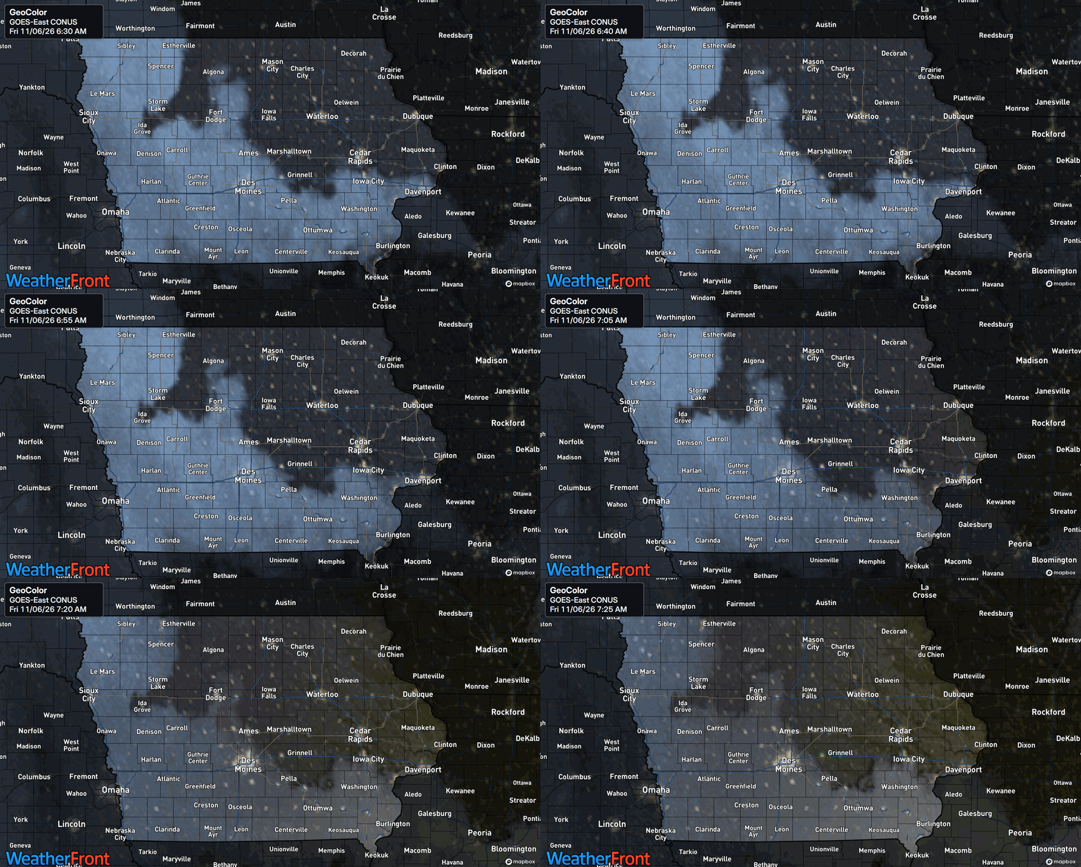
Friday morning is beginning with areas of fog, patchy drizzle, and stubborn low clouds across central and southern Iowa. The greatest potential for reduced visibility is in locations where moisture remains trapped near the ground, particularly across southern portions of the state. Drivers traveling early this morning should be prepared for changing visibility, especially along rural highways and in low-lying areas. Conditions should gradually improve through midmorning as drier air works southward and the lowest clouds begin to break apart. Northern and eastern Iowa have the best opportunity to see sunshine earlier in the day, while southwestern communities may remain cloudy longer. Despite the improving conditions, temperatures will remain on the chilly side throughout the afternoon.
The clearing trend is being driven by a change in the larger weather pattern as the system responsible for the recent stretch of cloudy weather moves farther east. Drier air is gradually spreading into Iowa, allowing some of the thick cloud cover to thin out. However, moisture remains trapped in the lowest levels of the atmosphere, making the timing of clearing somewhat difficult to predict. Areas around Des Moines and northeast Iowa have a reasonable chance of seeing periods of sunshine, although additional afternoon clouds could develop. Southwestern Iowa has a greater chance of holding onto cloud cover for much of the day. Confidence is moderate in the overall clearing trend, but lower regarding exactly when individual communities will see sustained sunshine.
Temperatures Stay in the 40s Before a Cold Friday Night
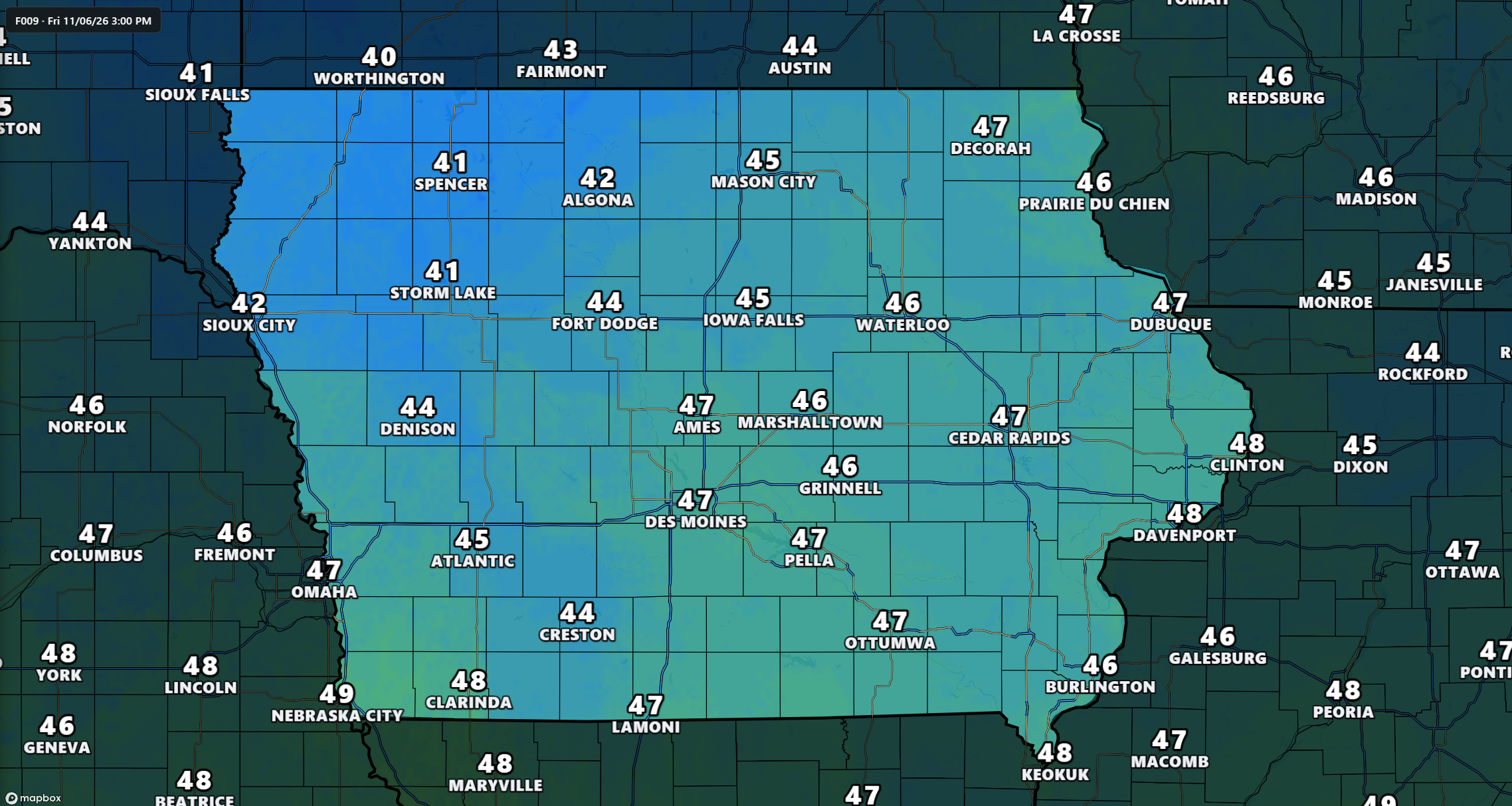
The temperature today will remain below average across much of Iowa, even where sunshine manages to return. Afternoon highs should generally reach the lower to upper 40s, with some locations in western Iowa approaching 50 degrees. Communities across northern and eastern Iowa can expect temperatures mainly in the middle to upper 40s, while cloudier areas of southwestern Iowa may struggle to warm as much. Winds will be noticeably lighter than during the previous few days, helping the afternoon feel more comfortable despite the cool temperatures. The difference between sunny and cloudy locations could be several degrees, making cloud cover an important part of the forecast. Overall, Friday will feel like a typical chilly November day rather than the beginning of the warmer pattern arriving this weekend.
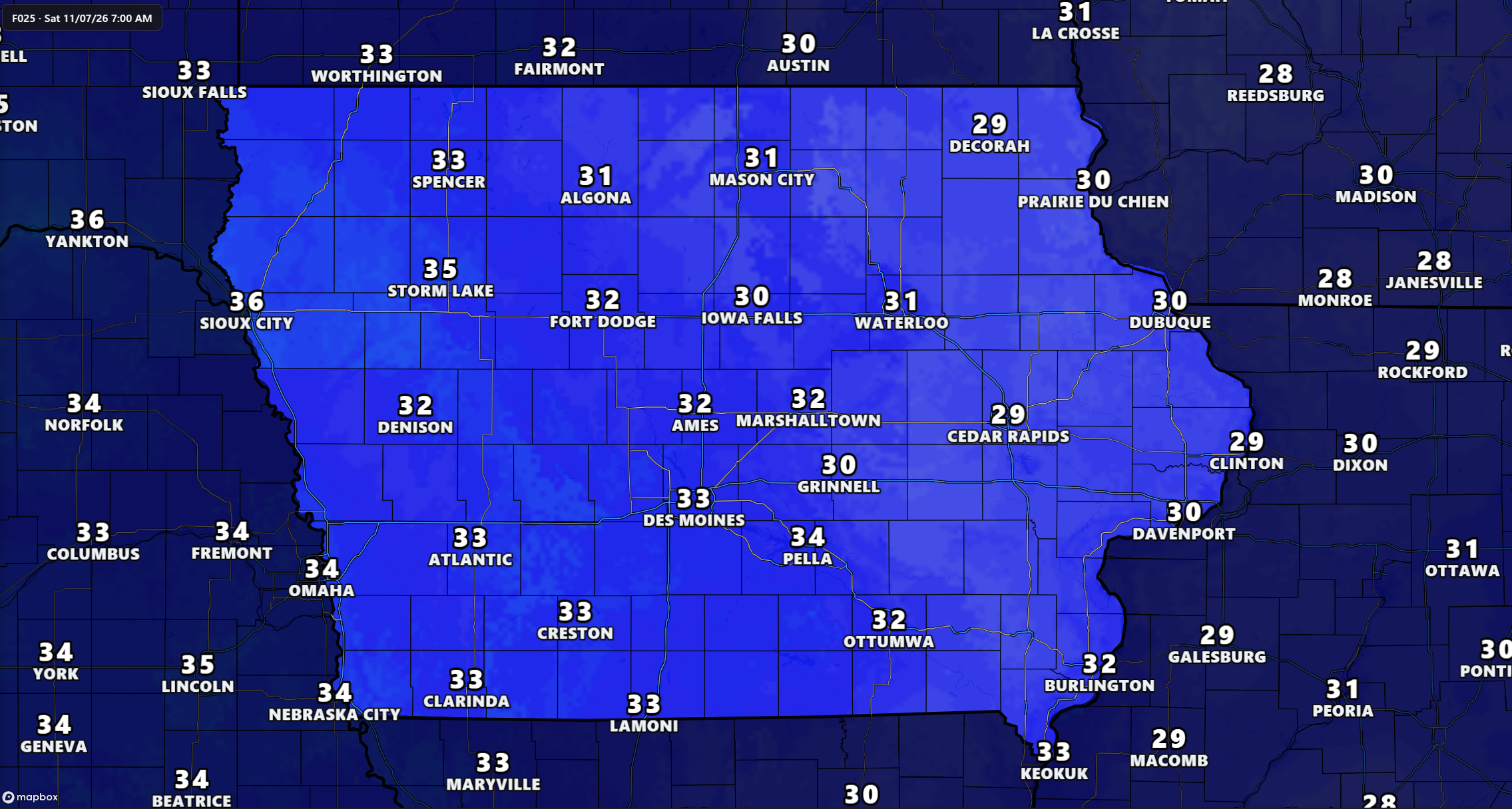
Temperatures will fall quickly Friday evening in locations where skies remain clear and winds become light. High pressure settling over Iowa will create favorable conditions for overnight cooling, particularly across eastern and northeastern sections of the state. Much of eastern Iowa is expected to drop into the middle and upper 20s by Saturday morning, while central and western Iowa should generally experience lows closer to the lower 30s. Some locations could remain slightly warmer if low clouds redevelop overnight and limit the amount of heat escaping from the ground. This makes the exact placement of the coldest temperatures somewhat uncertain outside eastern Iowa. Anyone with remaining sensitive outdoor plants should prepare for freezing conditions, especially east of Interstate 35.
Fog and Freezing Temperatures Could Affect Saturday Morning
Another round of fog could develop late Friday night into Saturday morning as light winds and lingering moisture combine across portions of Iowa. The greatest concern is across western and central Iowa, although fog could also form in southeastern locations where skies clear during the night. Some patches could become dense enough to reduce visibility below one mile, creating localized travel difficulties during the early morning hours. The exact coverage of fog remains uncertain because it depends on how much cloud cover remains overnight and how quickly temperatures fall. Areas that stay cloudy may experience less cooling, while locations that clear out could become colder and more favorable for fog formation. Drivers heading out early Saturday should allow extra time and watch for rapidly changing visibility.
Freezing temperatures will be another concern, particularly across eastern Iowa where the atmosphere is expected to remain relatively dry overnight. Lows in the 20s could end the growing season for any sensitive vegetation that has survived earlier cold weather. Central Iowa could see temperatures close to freezing, with some locations slipping below 32 degrees if skies clear long enough. Western Iowa should generally remain near the freezing mark, although localized colder pockets are possible. The combination of frost, fog, and cold temperatures could make Saturday morning feel considerably different from the milder afternoon expected later in the day. Confidence is highest in the freeze potential across eastern Iowa, while the temperature forecast farther west depends more heavily on overnight cloud conditions.
Weekend Forecast: Temperatures Begin Climbing Saturday
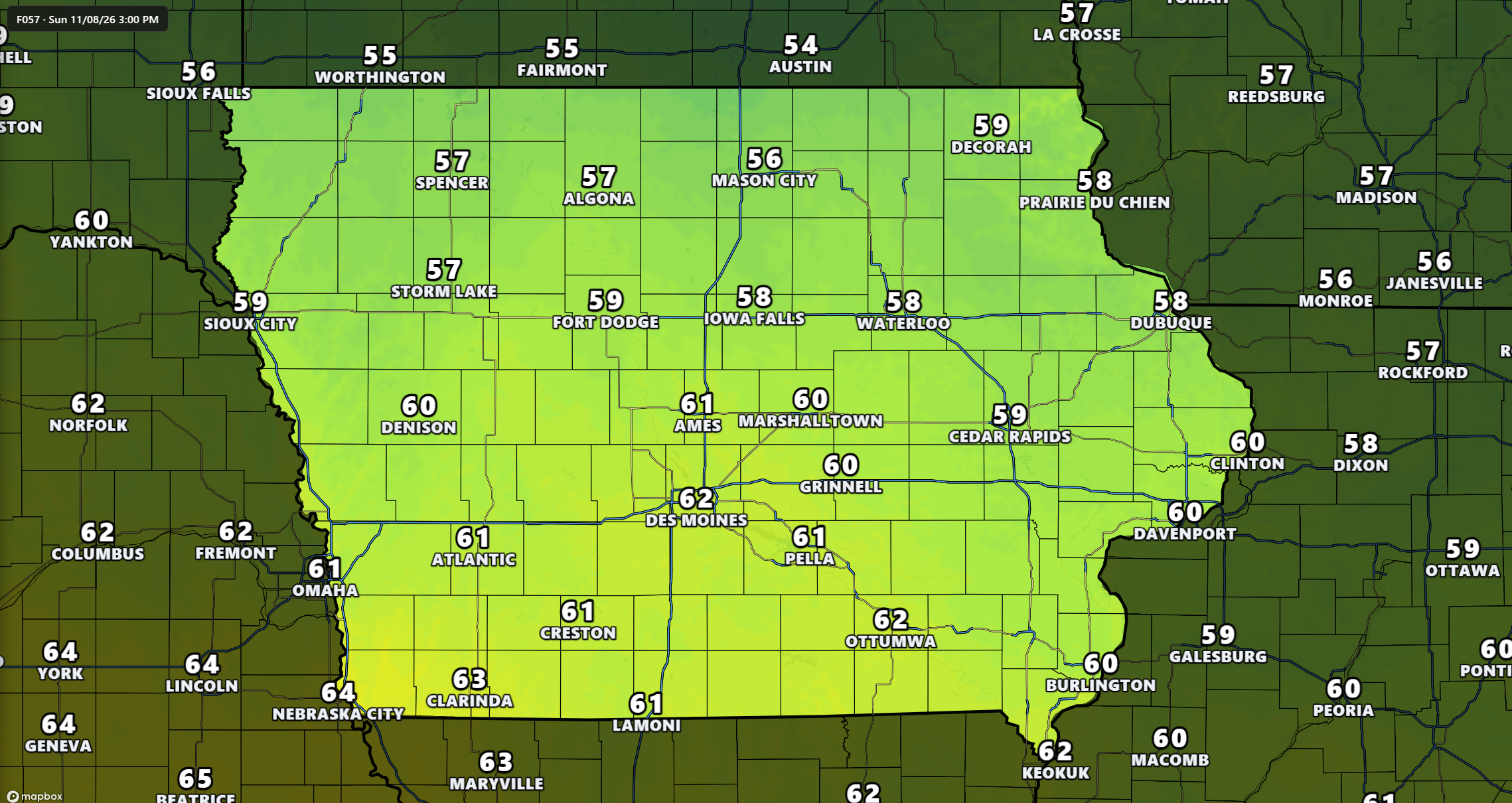
Saturday marks the beginning of a noticeable warming trend across Iowa, although the amount of improvement will depend on how quickly the morning clouds disappear. Most communities are expected to reach the lower to upper 50s, with some western and northwestern locations potentially climbing into the lower 60s. Eastern Iowa may remain a little cooler, with afternoon temperatures closer to the lower 50s. Winds should remain relatively light, and the absence of widespread precipitation will make Saturday a favorable day for outdoor plans. The main uncertainty involves stubborn low clouds that could keep some areas significantly cooler than currently expected. If cloud cover lingers longer than anticipated, temperatures could struggle to rise beyond the 40s in a few locations.
Sunday is shaping up to be the more reliably mild day of the weekend as warmer air becomes established across the region. Afternoon highs should reach the upper 50s to middle 60s across much of Iowa, with the warmest conditions favored in western and central sections. High pressure and a developing ridge of warmer air in the atmosphere will support the improvement. This ridge acts like a broad area of relatively warm, stable air that helps keep major storm systems away. Sunshine should be more common, although occasional passing clouds remain possible. For anyone planning yard work, outdoor recreation, or travel, Sunday currently offers one of the better weather opportunities of the upcoming week.
Monday Could Bring Some of Iowa’s Warmest Weather of the Week
The warming trend is expected to continue into Monday, with afternoon temperatures reaching the upper 50s to middle 60s across much of Iowa. Many central and eastern Iowa communities could see highs in the lower to middle 60s, placing temperatures nearly 10 degrees above the seasonal average in some locations. Western Iowa should experience similarly mild conditions before a weak cold front begins moving through the region. The warmer weather is being supported by a broad ridge of high pressure over the central United States, allowing milder air to spread across the Plains and Midwest. With little moisture available, the approaching weather disturbance is not expected to produce meaningful rainfall. Confidence is high that Monday will be warmer than average, although the exact high temperatures will depend on cloud cover and the timing of the approaching front.
A weak cold front is expected to move through portions of the region Monday afternoon or evening, bringing a gradual shift toward cooler conditions. This front will not have the moisture or atmospheric support needed to produce a widespread rain event. Winds may turn more northerly behind the boundary, allowing temperatures to settle back into the 50s by Tuesday, especially across northern and northwestern Iowa. Even with that cooling, temperatures should remain relatively comfortable for November. The front is not expected to bring the kind of sharp temperature drop or strong winds that sometimes accompany more powerful fall systems. Overall, the early-week forecast continues to favor quiet weather with limited impacts.
Rain Chances Remain Low Through Much of Next Week
Anyone hoping for a substantial rainfall event will likely have to wait a little longer, as the Iowa rain forecast remains largely dry through at least the middle of next week. Several weak weather disturbances are expected to move across the central United States, but most will pass through without enough moisture to generate widespread precipitation. The strongest storm systems are expected to remain well away from Iowa, with more active weather focused along portions of the East and West Coasts. High pressure over the central part of the country will continue to limit the development of organized rain-producing systems. Most Iowa communities should experience several consecutive days without measurable rainfall. Confidence is high in the overall dry pattern through the middle of next week.
There is a very small possibility of a passing light shower around Wednesday, mainly across northeastern Iowa and neighboring areas of Wisconsin and Minnesota. Some forecast models suggest that a weak disturbance could produce enough moisture for isolated showers behind a passing front. However, most guidance keeps the atmosphere too dry for meaningful precipitation, with the chance of a shower currently below 10 percent in the northeastern part of the region. Even if a shower develops, rainfall amounts would likely be minimal and significant impacts are not expected. There is no indication of an organized severe weather threat or widespread flooding concern during this period. The next more meaningful opportunity for precipitation may depend on how a developing western United States storm system evolves later next week or beyond.
Mild Temperatures Continue Through the Middle of Next Week
Following Monday’s warmer temperatures, Iowa should settle into a somewhat cooler but still seasonable to mild pattern for the middle of next week. Tuesday and Wednesday highs are generally expected to range through the 50s, with some central and southern locations potentially approaching the lower 60s. Overnight lows should commonly settle into the upper 30s and lower 40s, although cooler locations could fall a few degrees lower. These temperatures would remain near or above the averages for early November, particularly during the afternoon hours. Passing weather disturbances may bring periods of additional cloud cover, but widespread rainfall is not anticipated. The combination of mild temperatures and limited precipitation should keep travel conditions favorable across most of Iowa.
The atmosphere will remain influenced by a broad area of higher pressure over the central United States, even as weak disturbances move through the region. These disturbances may temporarily increase clouds or shift wind directions, but they are unlikely to produce major changes in the overall weather pattern. A slightly cooler period is possible behind the early-week front, especially across northern Iowa. However, there is currently little evidence of a sustained outbreak of unusually cold air through the middle of next week. Forecast confidence remains fairly high in the general temperature trend, although individual daily highs may change as the timing of passing disturbances becomes clearer. For now, the extended weather forecast continues to favor relatively comfortable November conditions.
Longer-Range Outlook Favors Above-Normal Temperatures
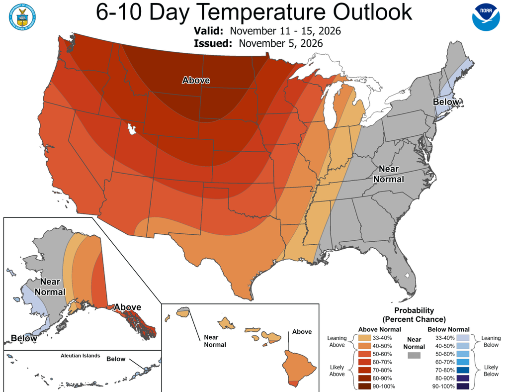
The longer-range Iowa weather outlook continues to favor warmer-than-average conditions through the middle of November. For November 11 through November 15, the Climate Prediction Center indicates increased chances of above-normal temperatures across much of the central United States, including Iowa. The strongest signal for unusual warmth is centered farther north across the Northern Plains and portions of Minnesota, but Iowa remains within the broader region favoring milder conditions. This pattern is associated with a persistent ridge of high pressure over the western and central United States. Such a setup generally limits the southward movement of cold Arctic air and supports periods of above-seasonal temperatures.
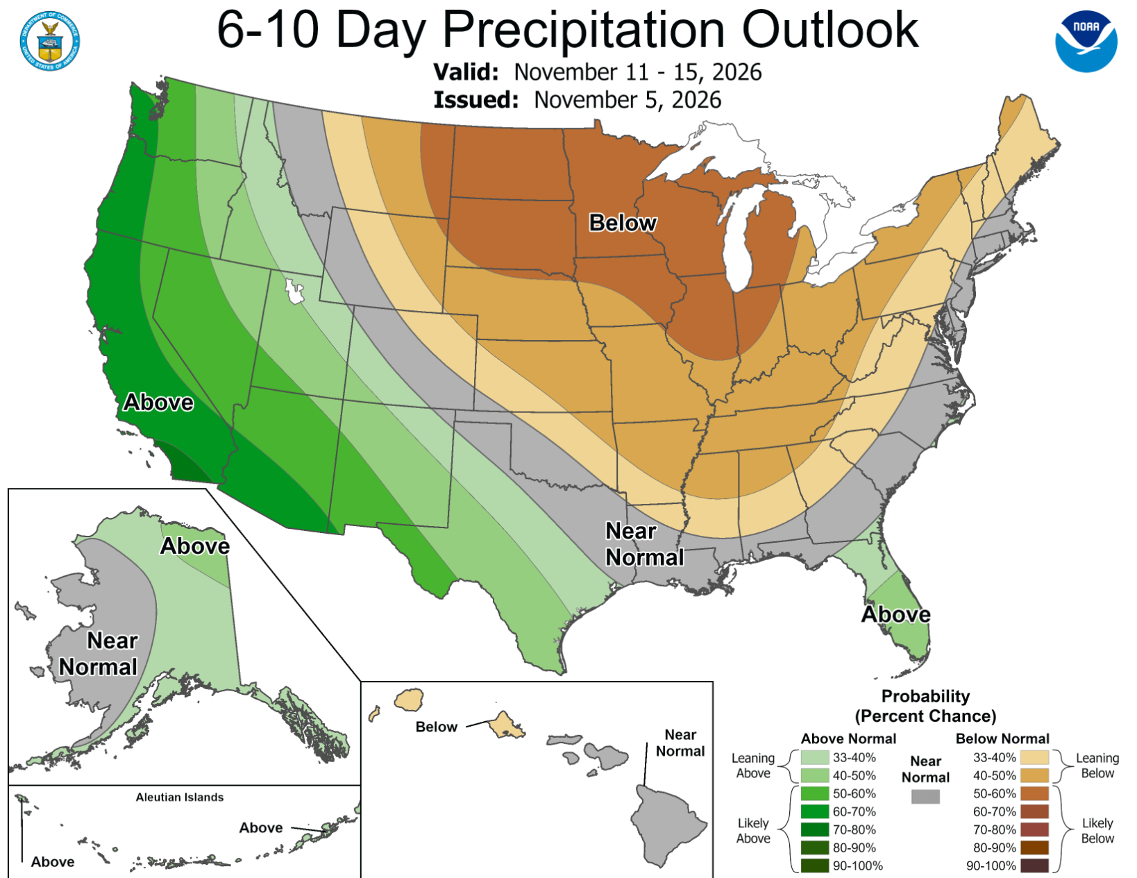
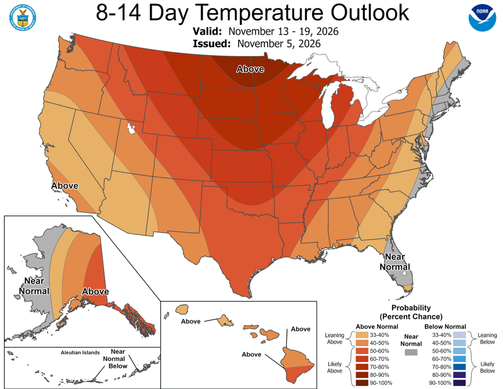
Precipitation during the November 11–15 period is expected to remain near or below normal across much of the north-central United States. The strongest signal for drier-than-average weather is centered over the Northern Plains, while Iowa sits closer to the broader transition between dry conditions and areas with less pronounced precipitation signals. Looking farther ahead to November 13–19, above-normal temperatures remain favored across nearly the entire country, including Iowa. The precipitation outlook becomes less certain during that second week as a more active weather pattern begins spreading eastward from the Pacific Coast. This could eventually provide opportunities for precipitation across portions of the central United States, although the timing and location of any Iowa rainfall remain unclear. The longer-range outlook does not provide enough detail to confidently predict a specific rain event for Iowa during that period.
Stay ahead of changing weather conditions across Iowa with the ISCN Weather app, available for free on iPhone and Android devices. Get the latest local forecasts, interactive weather radar, and important weather alerts wherever you go. You can also watch our live Iowa weather channel for continuous weather coverage, forecast updates, and the latest conditions across the state. Whether you’re planning your weekend or preparing for changing weather, IowaWeather.com and the ISCN Weather app help keep you informed and prepared.