Active Weather Pattern Ahead for Iowa with Multiple Rain Chances Through Halloween Weekend
Iowa is heading into a relatively active stretch of weather as several disturbances move across the Midwest over the next week. While portions of northern and western Iowa will deal with rain to begin the workweek, much of central, southern, and eastern Iowa will continue experiencing unseasonably mild temperatures. Additional opportunities for more widespread rainfall arrive during the second half of the week, including the possibility of thunderstorms heading into Halloween weekend.
Despite the unsettled forecast, there is little indication of a significant cooldown anytime soon. In fact, longer-range outlooks continue to favor above-normal temperatures across Iowa as we transition from October into November.
Monday: Rain Northwest, Mild Conditions Elsewhere
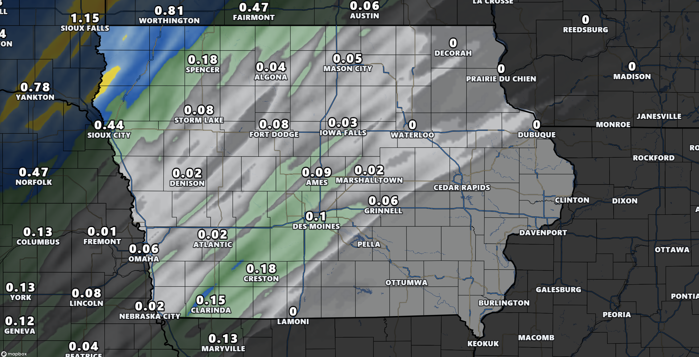
A developing low-pressure system moving through the Northern Plains is bringing widespread cloud cover and areas of rainfall to portions of Iowa this morning. However, conditions will vary considerably depending on where you live.
Northwestern Iowa, including communities around Sioux City, Spencer, and the Iowa Great Lakes, will experience the greatest potential for rain throughout the day. Some locations could see periods of steady rainfall, with a few embedded thunderstorms possible later this afternoon or evening. Severe weather is not expected with this activity.
Farther south and east, including Des Moines, Ames, Waterloo, Cedar Rapids, and the Quad Cities, conditions will remain predominantly cloudy but largely dry. A few light showers could drift into portions of western and north-central Iowa, although widespread rainfall is not anticipated across the central and eastern portions of the state.
One interesting aspect of today’s weather is the significant temperature difference expected across Iowa. Locations experiencing persistent rainfall in the northwest may struggle to climb out of the 40s and 50s, while portions of southern and southeastern Iowa could reach the lower to middle 70s.
This contrast is being driven by a frontal boundary separating cooler air across the Northern Plains from considerably warmer air positioned over the central Midwest.
Rainfall across northern and western Iowa should gradually diminish tonight as the low-pressure system moves northeastward.
Tuesday: A Brief Break Before More Rain Arrives
Tuesday should provide a temporary break from the more widespread precipitation chances as the first weather system departs the region.
While considerable cloud cover may linger across portions of Iowa, most locations should remain dry. There is a small possibility of isolated showers across far southwestern Iowa, although coverage is expected to remain limited.
Temperatures will generally range from the 60s into the lower and middle 70s, with the warmest conditions favored across southern and eastern Iowa.
Southerly winds will also return across portions of the state, helping temperatures recover in areas that experienced cooler and wetter conditions on Monday.
Unfortunately, the quieter conditions will not last particularly long.
Wednesday Night into Thursday: Widespread Rain and Thunderstorm Chances Return
Our next opportunity for more widespread precipitation is expected to develop Wednesday night and continue into Thursday morning.
A disturbance moving across the Northern Plains will help push a frontal boundary into Iowa. At the same time, increasing moisture will provide favorable conditions for showers and thunderstorms to develop across portions of the state.
Current forecast guidance suggests precipitation chances generally ranging from 40% to 70% across portions of Iowa during this period.
There is also some indication that a few thunderstorms could become stronger, particularly overnight Wednesday into early Thursday. Forecast models suggest enough elevated instability and strengthening winds just above the surface to support organized thunderstorm activity.
However, considerable uncertainty remains regarding the placement, intensity, and overall coverage of thunderstorms. It is too early to determine whether any meaningful severe weather threat will materialize.
For now, the primary concern appears to be another opportunity for beneficial rainfall, with thunderstorm potential something we will continue monitoring as newer forecast guidance becomes available.
Friday Through Saturday: Rain Could Impact Halloween Plans
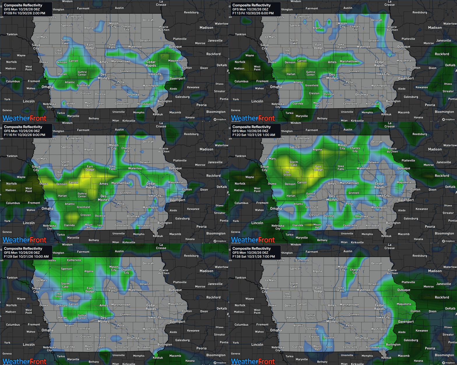
Another potentially more substantial weather system is expected to approach Iowa toward the end of the workweek, bringing additional opportunities for widespread rainfall and thunderstorms.
This particular system is worth watching because of its timing around Halloween on Saturday, October 31.
Forecast guidance is showing relatively good agreement that another disturbance and an accompanying surge of moisture will move into the Midwest sometime Friday through Saturday.
Current probabilities suggest a 40% to 60% chance of precipitation developing across portions of Iowa on Friday, with probabilities increasing to around 50% to 70% in some areas on Saturday.
However, these probabilities do not mean that it will rain continuously throughout the day. They simply reflect the likelihood of measurable precipitation occurring during the forecast periods.
There is still considerable uncertainty regarding the exact arrival and departure times of this system. Some forecast solutions bring precipitation into Iowa during Friday and continue it into Saturday, while others delay the more widespread rainfall until Saturday night or even Sunday.
For families planning trick-or-treating activities Saturday evening, it is too early to say whether rain will directly affect those plans. Nevertheless, the increasing potential for precipitation makes this a forecast worth monitoring throughout the week.
The good news is that temperatures are expected to remain relatively mild for late October, with many locations continuing to experience highs in the 60s and potentially lower 70s.
Looking Ahead: Above-Normal Temperatures Favored into Early November
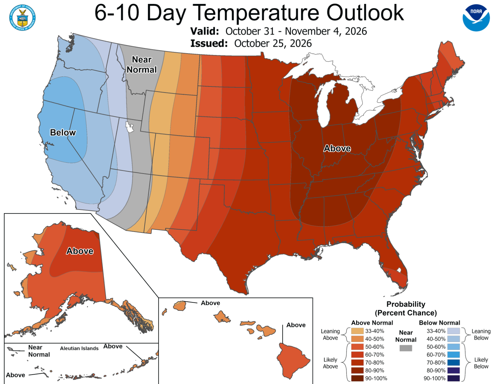
For those wondering when more typical November temperatures might arrive, the latest extended outlooks suggest Iowa could continue experiencing relatively mild conditions into the beginning of next month.
The Climate Prediction Center is favoring above-normal temperatures across much of the central and eastern United States during both the October 31 through November 4 and November 2 through November 8 forecast periods.
This outlook is supported by a broad upper-level weather pattern featuring higher atmospheric pressure across the central and eastern United States. Such a configuration generally favors milder-than-average conditions across Iowa.
The outlook also favors above-normal precipitation across much of the country, including the Midwest, suggesting the relatively active weather pattern could continue beyond Halloween weekend.
It is important to understand that these outlooks describe the probability of temperatures and precipitation being above or below their historical averages over several days. They do not indicate that every individual day will be warm or rainy.
While occasional cooler days and passing frontal systems are certainly possible, there is currently little evidence supporting a prolonged period of significantly below-normal temperatures across Iowa during the first week of November.
Stay with IowaWeather.com and the Iowa Storm Chasing Network for the latest forecast updates as we continue tracking these developing weather systems across Iowa.