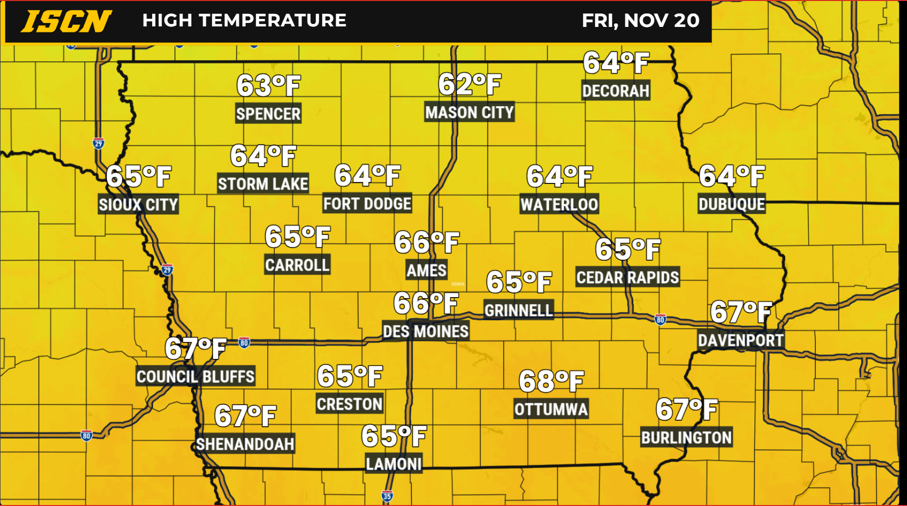
Iowa is in for several more days of unusually warm November weather, but changes are on the horizon as a series of weather systems moves across the central United States. Temperatures will climb into the 60s across much of the state through the end of the workweek, accompanied by gusty southerly winds. Rain chances will increase Friday night into Saturday before a cold front sends temperatures tumbling back into the 40s on Sunday.
While the upcoming cooldown will be noticeable, temperatures will simply be returning closer to what is typical for the middle of November. Looking farther ahead, another weather system could affect the region during Thanksgiving week, although considerable uncertainty remains regarding its track and potential impacts.
Mild Temperatures and Gusty Winds Through Wednesday
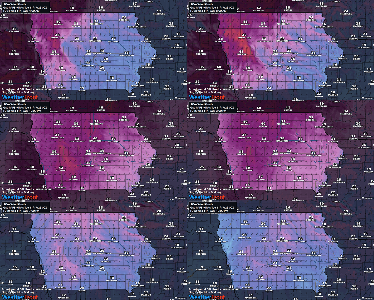
Wednesday will bring another round of warm temperatures and gusty winds as the storm system tracks northeastward through the Dakotas toward southern Canada. High temperatures should reach the upper 50s to middle 60s across much of Iowa, with the warmest readings favored in areas that experience afternoon clearing. Some western locations could climb into the upper 60s if clouds dissipate early enough.
The strongest winds are expected across northwestern and northern Iowa, where gusts could approach or exceed 40 mph. Wind Advisory criteria could be reached in portions of northwestern Iowa, depending on how effectively stronger winds above the surface mix downward.
Cloud cover will play an important role in determining both temperatures and wind speeds. Lingering low clouds could limit daytime warming and prevent some of the strongest winds from reaching the ground.
As drier air moves into western Iowa Wednesday afternoon, humidity levels will also decrease. Combined with gusty winds and dry vegetation, this could lead to an elevated fire danger in some locations, particularly where fields and grasses remain dry.
Warm Weather Continues Thursday and Friday
A weak cold front will approach Iowa Wednesday night into Thursday, but widespread precipitation is not expected with its passage. Limited atmospheric moisture should keep most locations dry, although a few isolated light showers cannot be completely ruled out.
Temperatures Thursday will remain above normal, despite some differences across the state. Northern and northwestern Iowa may experience highs in the 50s, while southern and southeastern Iowa could climb into the lower to middle 60s.
By Friday, another developing low-pressure system over the Rockies will draw warmer air northward into Iowa. Afternoon temperatures are expected to return to the 60s across much of the state, with some areas potentially reaching the upper 60s. These readings would be considerably warmer than typical mid-November temperatures.
Southerly winds will also strengthen again Friday, especially across western Iowa. Gusts of 30 to 40 mph appear possible, with some locations potentially experiencing gusts approaching 45 mph. Increasing clouds may affect how warm temperatures become, but the overall pattern will continue to favor an unusually mild end to the workweek.
Rain Chances Increase Friday Night Into Saturday
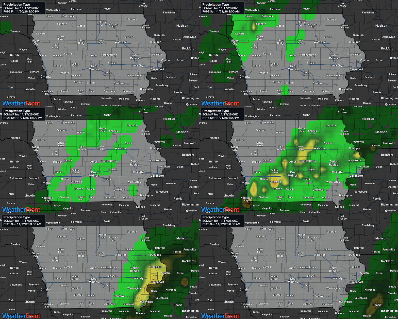
The most widespread precipitation opportunity of the week is expected to arrive late Friday into Saturday as another storm system moves eastward from the Rockies. Rain chances will initially increase across western and northwestern Iowa Friday night before spreading eastward across the state overnight and into Saturday.
Saturday looks to be the primary period for showers across much of the state, although the exact timing and coverage will depend on how the storm system develops. There are still some differences among forecast models regarding the strength and track of the surface low. Some solutions favor a more organized area of precipitation, while others move the system through more quickly and produce lighter rainfall totals.
At this point, the overall signal favors relatively light precipitation for many locations. Some forecast guidance suggests rainfall amounts generally under one-quarter inch, although locally higher totals cannot be ruled out. A few isolated thunderstorms are possible if sufficient instability develops, particularly toward southeastern Iowa. Rain should gradually diminish Saturday night as the associated cold front moves east of Iowa.
Much Cooler Air Arrives Sunday
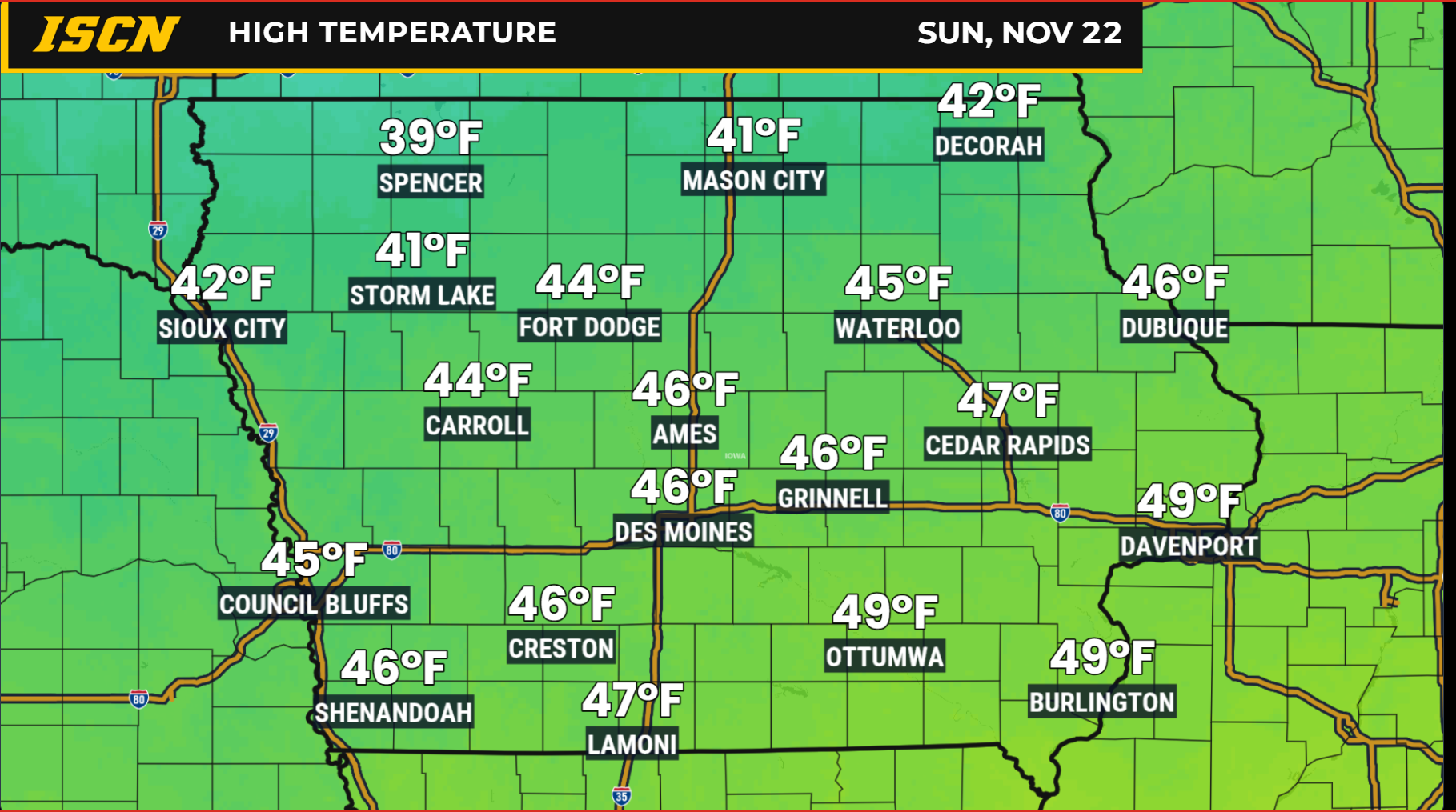
After several days of temperatures reaching the 60s, Sunday will feel noticeably different across Iowa. A cold front moving through Saturday night into early Sunday will usher in a cooler air mass accompanied by northwesterly winds.
Afternoon highs Sunday are expected to reach only the 40s across much of the state, representing a temperature drop of roughly 15 to 25 degrees compared to the warmest readings late in the workweek. Morning temperatures could fall into the 20s across portions of western and northwestern Iowa, with colder conditions becoming more widespread as the cooler air settles into the region.
Despite the sharp change, Sunday’s temperatures will be much closer to seasonal averages for the second half of November. The cooler pattern is expected to persist into Monday and potentially through the early portion of Thanksgiving week.
Could Iowa See Snow During Thanksgiving Week?
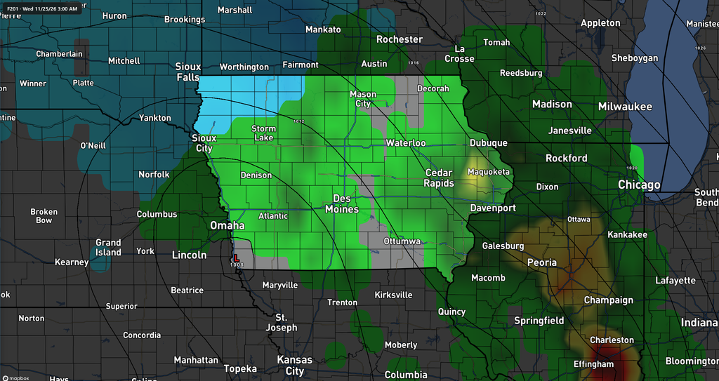
Looking beyond the weekend, forecast guidance is beginning to indicate the possibility of another weather system moving through the central United States around Tuesday or Wednesday of next week, November 24–25. This system could become relevant for Thanksgiving travel, particularly if precipitation develops while colder air remains in place.
Some ensemble guidance suggests that temperatures could be cold enough for snow in portions of the broader region. However, confidence remains low regarding the system’s exact track, strength, timing, and available moisture.
It is much too early to determine whether Iowa will experience rain, snow, a mixture of precipitation, or primarily dry conditions. The American GEFS and European ECMWF ensemble systems also show differences in the magnitude of the colder air expected across the region, adding another layer of uncertainty to the forecast.
For now, this is simply a system worth monitoring rather than a reason to anticipate significant winter weather. Travelers planning to hit the road ahead of Thanksgiving should continue checking updated forecasts as the holiday approaches and forecast confidence improves.
Stay with IowaWeather.com and the Iowa Storm Chasing Network for continued updates on Iowa’s changing weather pattern and the latest forecast information heading into the Thanksgiving holiday.