Iowa will enjoy several days of unusually mild November weather this week, with temperatures climbing into the 50s and 60s. However, strengthening winds will become increasingly noticeable through Wednesday before a couple of weather systems bring rain chances back into the forecast later this week.
A Pleasant Start to the Workweek
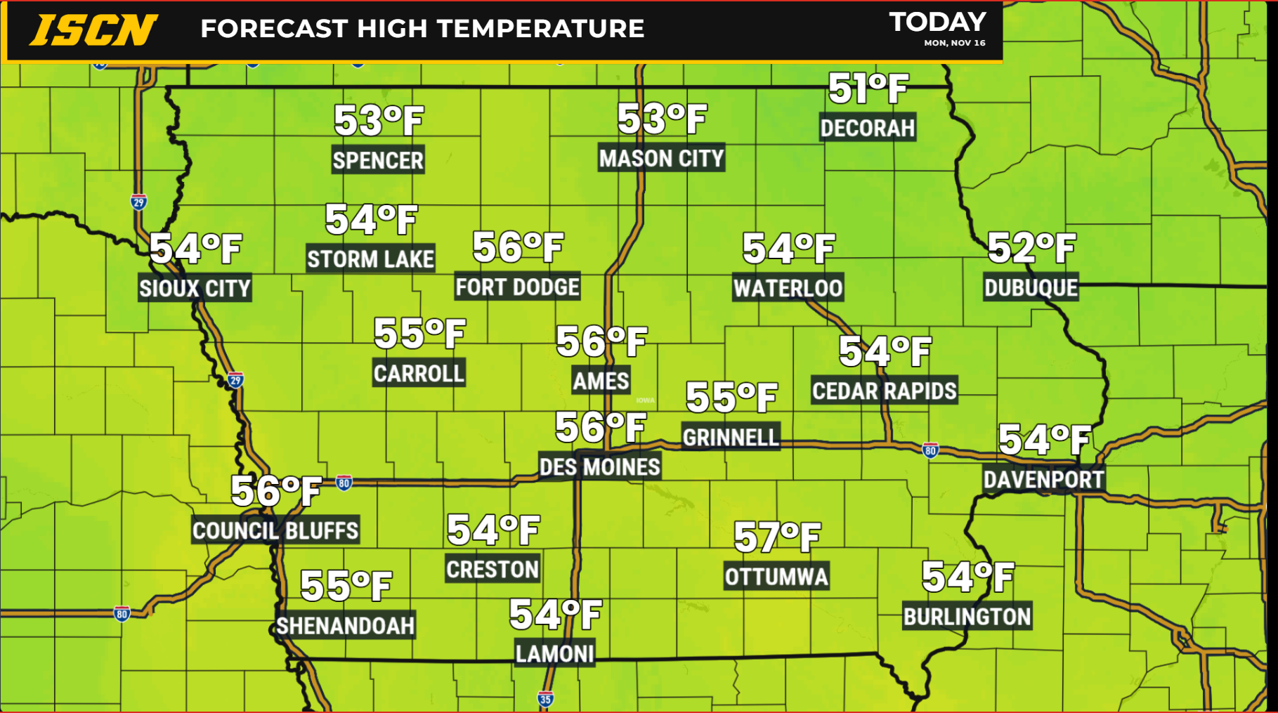
Monday is shaping up to be another pleasant November day across Iowa as high pressure continues to influence our weather. Following a chilly morning with temperatures near or below freezing in many locations, afternoon temperatures will recover nicely into the 50s.
Mostly sunny skies are expected across much of the state, with southerly winds gradually increasing throughout the day. The strongest winds will be found across northern and northwestern Iowa, where occasional gusts of 25 to 30 mph will be possible. Elsewhere, winds will generally be lighter, particularly across eastern Iowa.
This warming trend is being driven by a developing area of low pressure across the western United States and high pressure shifting east of Iowa. The resulting southerly flow will transport warmer air northward into the Midwest over the next several days.
Temperatures Climb Into the 60s by Midweek
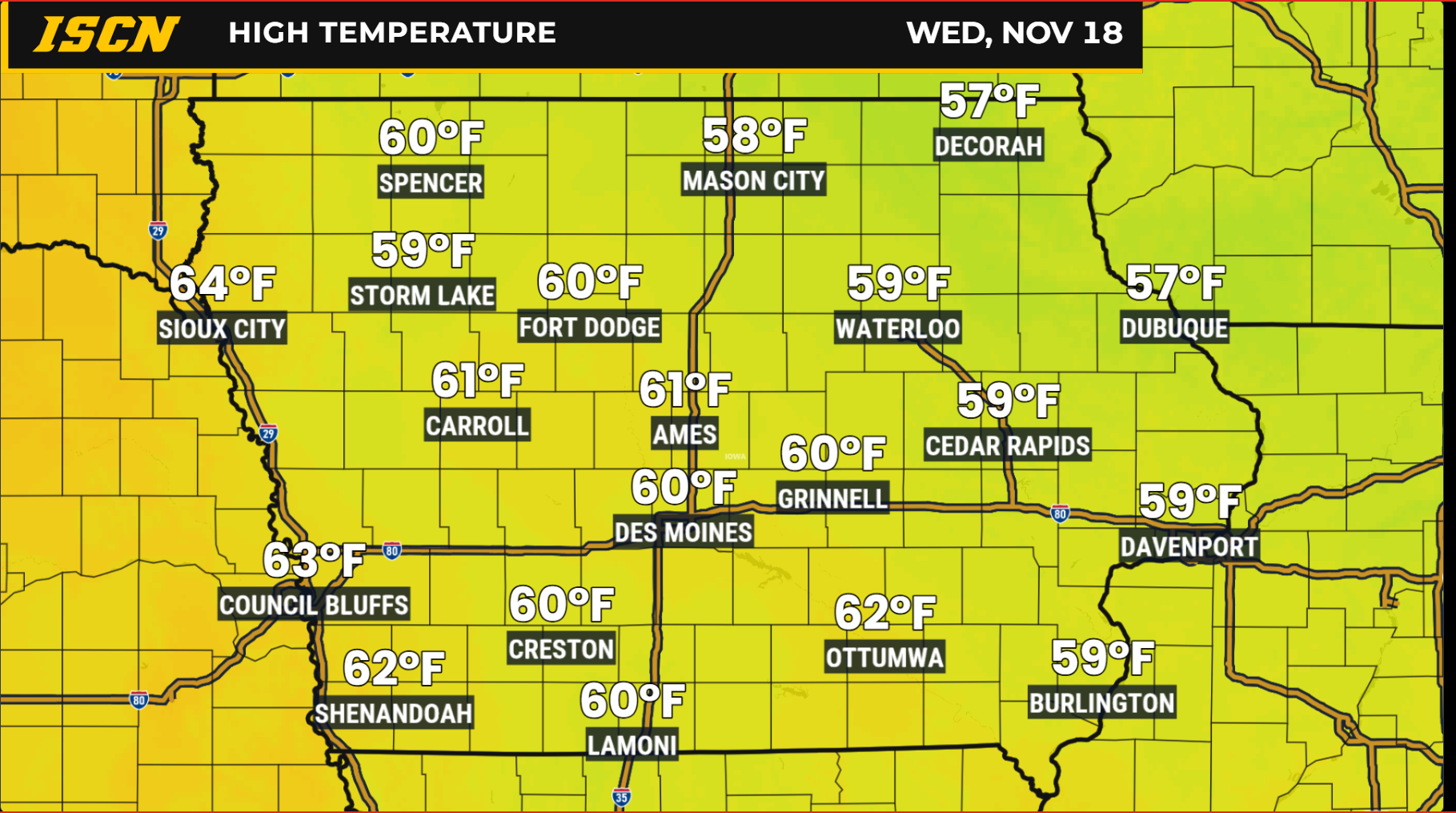
The warming trend will continue Tuesday and Wednesday, with afternoon temperatures running well above what we would normally expect during the middle of November.
Tuesday afternoon should feature widespread highs in the middle to upper 50s, with some locations reaching the lower 60s. By Wednesday, temperatures could climb into the lower to middle 60s across western Iowa, while central and eastern Iowa generally experience highs in the upper 50s to lower 60s.
For perspective, normal afternoon highs during this time of year are generally in the lower to middle 40s across Iowa. That means some locations could experience temperatures 10 to 20 degrees above average.
Overnight temperatures will also become milder as southerly winds and increasing cloud cover limit how quickly temperatures fall after sunset.
Strong Winds Become a Bigger Story Tuesday and Wednesday
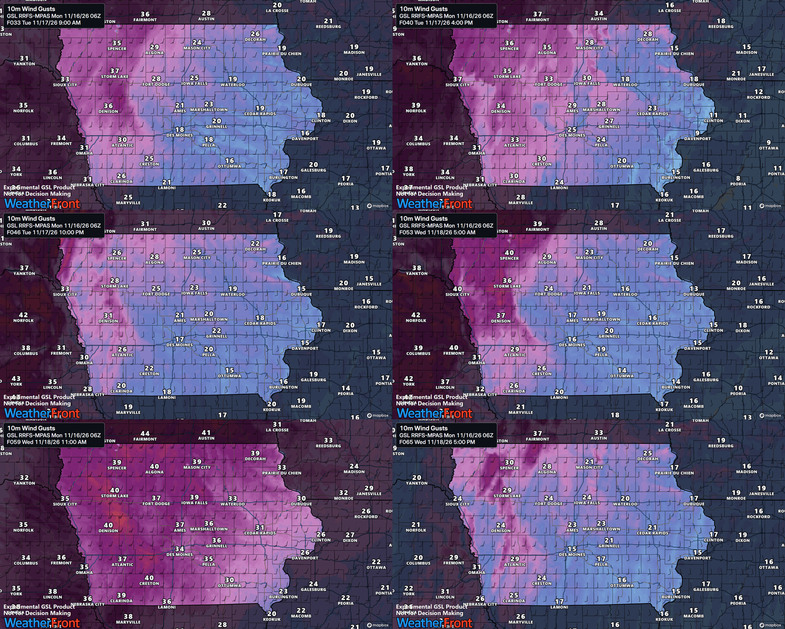
While the warmer temperatures will certainly be welcome, the tradeoff will be increasingly gusty winds. As low pressure strengthens across the Plains, the difference in atmospheric pressure between that system and high pressure to our east will increase. This will produce stronger southerly winds across Iowa.
Wind gusts could exceed 30 mph across portions of northern and western Iowa on Tuesday, with even stronger winds expected Wednesday.
Wednesday currently appears to be the windiest day of the week, with widespread gusts of 30 to 40 mph possible. Parts of northwestern Iowa could experience occasional gusts approaching 45 mph. These conditions could make travel more difficult for high-profile vehicles, particularly on east-west roadways.
The combination of dry vegetation, above-normal temperatures, and gusty winds will also increase grassland fire danger, especially across northwestern Iowa. Anyone working with equipment outdoors should use caution to avoid accidentally starting a fire.
A Small Chance for Showers Wednesday Night Into Thursday
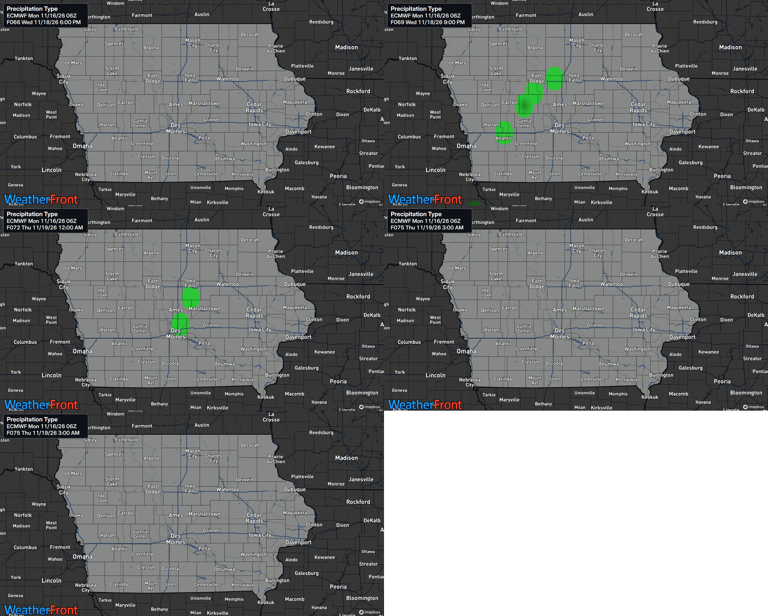
Our first opportunity for precipitation arrives as a relatively weak disturbance moves through the region late Wednesday into Thursday. A cold front will accompany this system, bringing a shift in wind direction and the possibility of a few scattered showers.
However, moisture availability remains a significant question. Despite favorable atmospheric conditions for producing some precipitation, dry air could prevent much of the developing rainfall from reaching the ground. At this point, rain chances generally remain around 10 to 20 percent, and many locations may stay completely dry. A few isolated thunderstorms cannot be ruled out, particularly across northwestern Iowa, but severe weather is not anticipated.
Better Rain Chances Arrive Friday Into Saturday
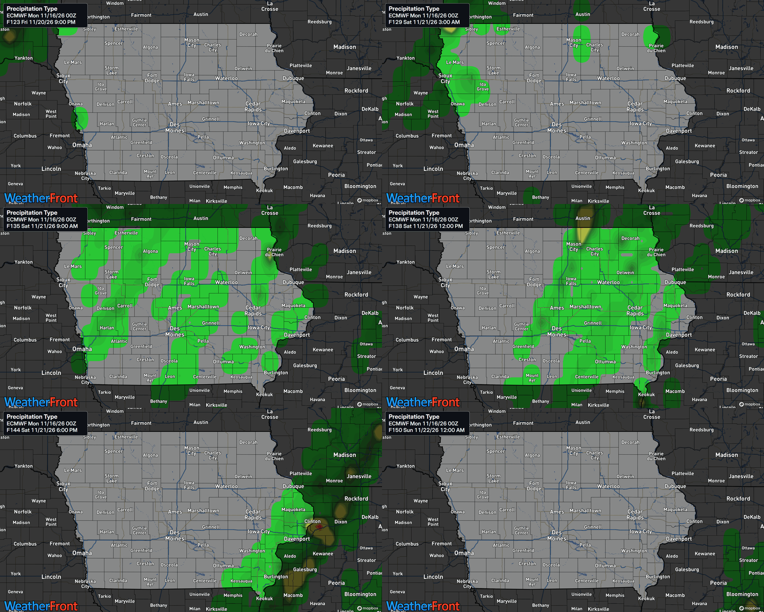
A stronger storm system is expected to move out of the western United States and into the Plains toward the end of the workweek. This system will bring a better opportunity for widespread precipitation across Iowa Friday into Saturday.
Current rain probabilities range from approximately 50 to 80 percent across portions of the state, although confidence in the exact timing, coverage, and rainfall amounts remains limited. Rain showers appear to be the primary precipitation type, with a few thunderstorms also possible.
There are still important differences among forecast models regarding how quickly the storm system moves and how its associated cold front develops. These details will determine where the heaviest rainfall occurs and how long precipitation continues. Some forecast guidance suggests the system could move through relatively quickly, while other solutions support a slower progression that would allow rain to linger longer.
Although cooler air will eventually follow the system, temperatures currently appear warm enough to keep precipitation primarily in the form of rain. A brief rain-snow mix cannot be completely ruled out in far northern Iowa as the system departs, but the probability remains low.
Looking Ahead Toward Thanksgiving Week
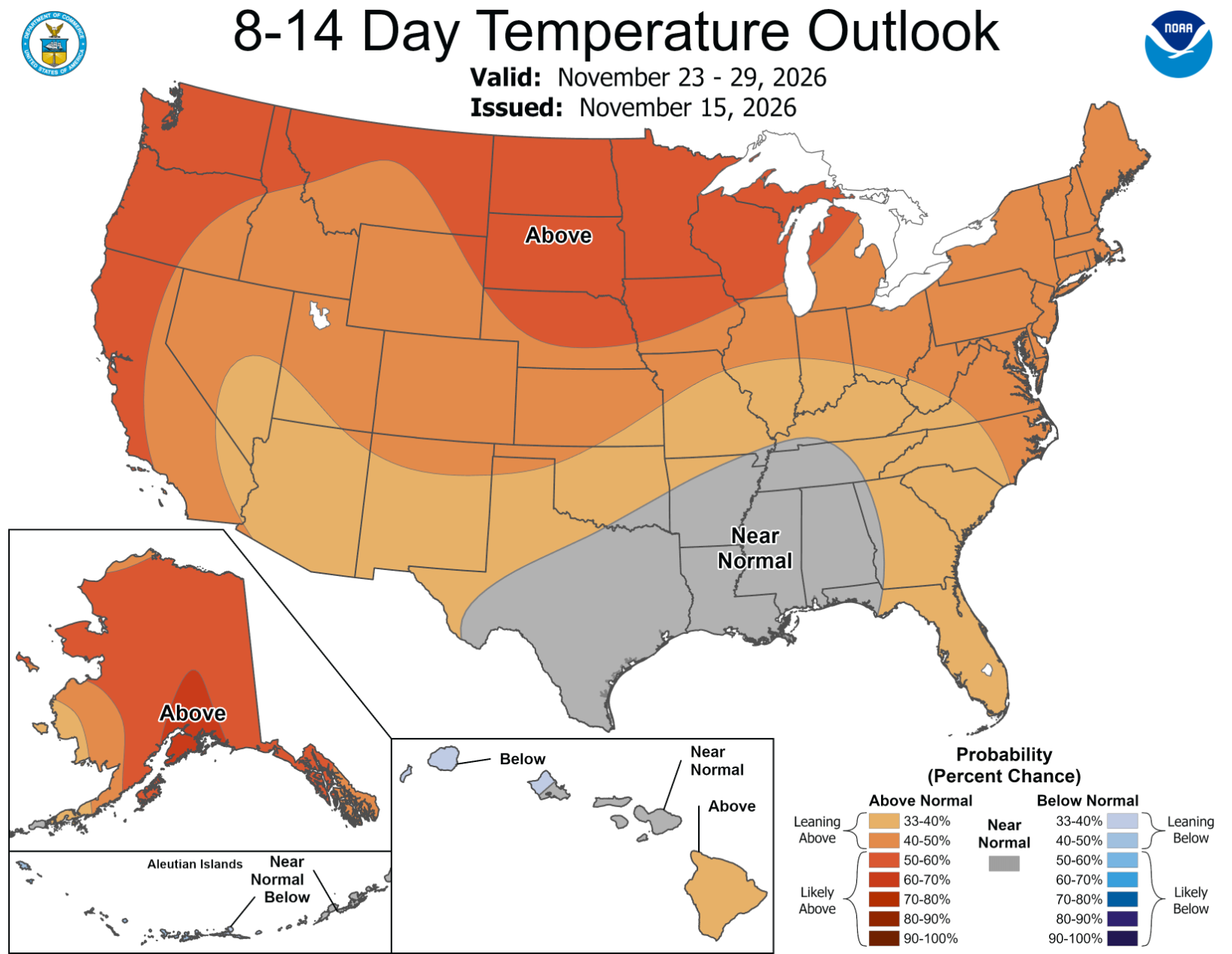
The Climate Prediction Center’s outlook for November 21–25 favors above-normal temperatures across much of the eastern United States, including the Midwest. The outlook also suggests an increased potential for precipitation across portions of the central United States as a more active weather pattern develops.
Looking farther ahead to November 23–29, temperatures across the northern United States are generally favored to remain above seasonal averages, while precipitation trends become less certain across the Upper Midwest.
For Iowa, this suggests that the overall pattern may continue to favor relatively mild conditions as Thanksgiving approaches, although individual storm systems and cold fronts could still bring temporary temperature changes. There is not yet enough confidence to determine specific weather conditions for Thanksgiving Day.
Stay with IowaWeather.com and the Iowa Storm Chasing Network for the latest forecast updates throughout the week.