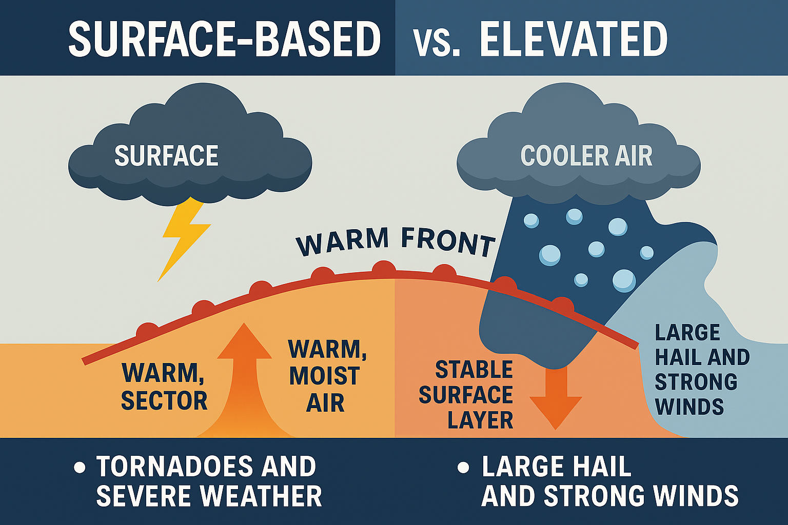
Elevated vs. Surface-Based Thunderstorms: Why It Matters in Severe Weather Forecasting

When severe weather strikes, meteorologists often use terms like surface-based storms and elevated storms. While these phrases are common in the weather community, they’re rarely explained in detail to the public. Understanding the difference is critical—because whether a storm is rooted at the surface or elevated above it can determine if we’re talking about a tornado threat or a hailstorm.
As someone who has spent years storm chasing and analyzing Iowa’s volatile weather patterns, I want to break this down in simple terms so you can better understand what these storms mean during a severe weather event.
What Are Surface-Based Storms?
A surface-based storm forms when rising air parcels originate directly from the warm, moist surface layer of the atmosphere. These are the classic thunderstorms you think of when a humid summer day boils over into towering clouds.
- Where they form: Typically in the warm sector of a storm system, south of a warm front.
- Why they matter: These storms are the ones most capable of producing supercells, tornadoes, and damaging winds.
- Key ingredients: Surface heating, rich low-level moisture, and instability.
Because they are directly connected to the ground layer, surface-based storms can tap into low-level wind shear, which makes them especially dangerous.
What Are Elevated Storms?
An elevated storm—sometimes called a high-based thunderstorm—does not draw its energy from the warm, moist surface air. Instead, it develops above a stable surface layer, pulling instability from a warmer air mass aloft.
- Where they form: Common in the cold sector of a storm system, north of a warm front.
- What they produce: These storms are notorious for large hail and sometimes strong winds, but tornadoes are far less likely because they’re cut off from surface inflow.
- Technical term: Meteorologists often refer to this as elevated convection.
Even though elevated storms may not have the same tornado potential, they can still produce dangerous elevated supercells with very large hail—making them a serious hazard.
Real-World Example: Iowa Warm Front Case
To illustrate, let’s look at a real scenario. A warm front draped across Iowa separated chilly 50s to the north from 80-degree heat to the south. In the morning, the front lifted northward, but by afternoon, it sagged back southeast.
Thunderstorms developed along this boundary but were quickly pushed into the colder air mass north of the front. The result? Elevated storms.
Because these storms lost access to surface heating, they lacked strong low-level rotation. Instead of tornadoes, the environment greatly enhanced the large hail threat.
If those same storms had lingered along the boundary or fired south of the front, they would have remained surface based—and the risk for tornadoes would have been much higher.
Why This Matters for Severe Weather Safety
Knowing whether a storm is surface-based or elevated isn’t just a meteorological detail—it directly affects forecasting and public safety messaging.
- Surface-based storms: Higher tornado risk.
- Elevated storms: Higher hail risk, lower tornado risk, but still dangerous.
For storm chasers, forecasters, and weather enthusiasts, this distinction helps explain why two storms can form in the same area but produce very different hazards.
The terms surface-based storms and elevated storms are more than jargon—they’re keys to understanding severe weather behavior. By knowing whether storms are rooted at the surface or aloft, we can better anticipate whether the main threat is tornadoes, hail, or damaging winds.
As someone who forecasts daily for Iowans and has tracked countless storm systems firsthand, I can say this knowledge isn’t just theoretical—it’s life-saving.
Frequently Asked Questions About Surface-Based and Elevated Storms
Can elevated storms produce tornadoes?
While rare, it’s not impossible. Most elevated storms are cut off from surface inflow, which limits their ability to develop tornadoes. However, in unusual cases, elevated supercells can still produce weak or brief tornadoes. The primary risk remains large hail and sometimes strong winds.
What is an elevated supercell?
An elevated supercell is a thunderstorm with rotating updrafts that forms above a stable surface layer. Unlike surface-based supercells, elevated supercells typically don’t produce tornadoes but can unleash very large hail and severe lightning.
Why are surface-based storms more dangerous?
Surface-based storms tap into warm, moist air at the ground level. This connection to the surface allows them to interact with low-level wind shear, which makes them capable of producing tornadoes, damaging winds, and other severe hazards.
What does “high-based thunderstorm” mean?
A high-based thunderstorm is another way of describing an elevated storm. The storm’s base is located higher above the ground, usually because of dry or cool air near the surface. These storms often produce lightning and hail but are less likely to generate tornadoes.
How can I tell if a storm is elevated or surface based?
Meteorologists use weather balloons, radar, and surface observations to determine storm type. A quick rule of thumb: if storms are forming north of a warm front (in cooler surface air), they’re likely elevated. If they’re forming in the warm sector south of a front, they’re usually surface-based.