Iowa Weather Forecast: Morning Thunderstorms Give Way to Gusty Winds and a November Cooldown
Iowa’s weather is undergoing a noticeable change Wednesday as a fast-moving storm system brings morning showers and thunderstorms to portions of the state, followed by gusty northwest winds and falling temperatures. The most active weather is concentrated across eastern Iowa, where scattered thunderstorms have developed during the morning hours. Meanwhile, western and central Iowa will experience a mostly dry but increasingly blustery day as colder air begins moving into the region.
The bigger weather story extends beyond Wednesday’s showers. A much colder air mass from Canada will settle across Iowa through the end of the workweek, bringing afternoon temperatures into the 40s and overnight lows well below freezing in many communities. Friday morning looks especially chilly, with temperatures falling into the lower and middle 20s across much of the state. The upcoming weekend should remain largely dry, although a separate storm system could bring a small chance of light rain to southwest Iowa on Sunday.
Strong Northwest Winds Make Wednesday Feel Colder
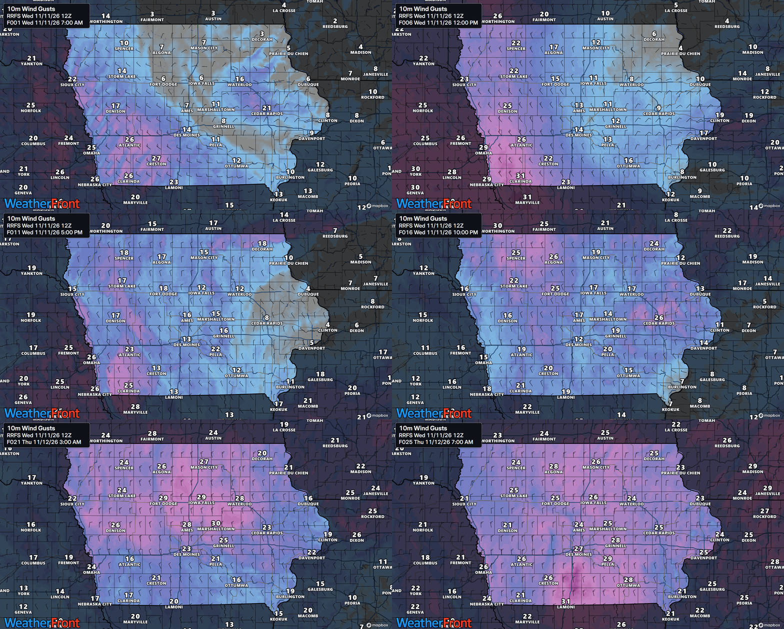
Gusty northwest winds will become the most widespread weather impact across Iowa on Wednesday as the morning storm system moves away from the state. Winds will generally remain sustained between 15 and 20 mph, with occasional gusts reaching 25 to 35 mph. The strongest gusts are expected across the southwest half of Iowa, including portions of western and central Iowa, where the pressure difference behind the departing system will be greatest. Communities across eastern Iowa should also experience increasing northwest winds during the afternoon, although gusts will generally be closer to 15 to 25 mph. The wind will make outdoor conditions feel noticeably cooler than the actual air temperature, especially in open areas. Drivers of high-profile vehicles may also notice occasional crosswinds on exposed highways.
The stronger winds are developing because of a tightening pressure gradient behind a cold front moving through the region. A pressure gradient is simply the difference in atmospheric pressure between two areas, and larger differences typically produce stronger winds. As the low-pressure system tracks eastward, colder Canadian air will be pulled southward across Iowa on northwest winds. Wind speeds should gradually decrease later Wednesday afternoon and evening, but breezy conditions will continue into Thursday. Additional gusts of 15 to 30 mph remain possible Thursday as the colder air continues spreading into the state. By Friday and Saturday, high pressure should bring lighter winds and more comfortable conditions despite the chilly temperatures.
Temperatures Begin Falling as Canadian Air Arrives
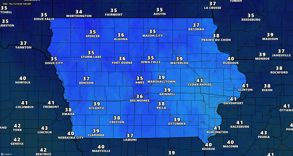
Wednesday marks the beginning of a cooling trend that will continue through the end of the week across Iowa. Afternoon temperatures will generally reach the upper 40s and 50s, although portions of southwest Iowa could remain milder with readings approaching 60 degrees. Northern and northeastern Iowa will be among the cooler locations, while southern and western communities may hold onto somewhat warmer temperatures before the colder air fully arrives. These readings will be lower than the unusually mild conditions experienced earlier in the week, and gusty winds will make the change feel more pronounced. The temperature difference will become even more noticeable Wednesday evening as the sun sets and colder air continues moving southward. By Thursday morning, many Iowa communities will wake up to temperatures in the upper 20s and 30s.
The cooling trend is being driven by a change in the upper-level weather pattern across North America. A large dip in the jet stream is allowing colder air from Canada to spread into the Upper Midwest, replacing the milder air that dominated earlier in the week. This northwest flow will keep temperatures suppressed across Iowa through at least Saturday. High temperatures Thursday and Friday will generally remain in the 40s, with some northern and northeastern communities struggling to get much above 40 degrees. The coldest afternoon readings may occur across far northern Iowa, where temperatures could remain in the upper 30s on some days. Forecast confidence is high that the state will experience several days of considerably cooler weather before temperatures begin recovering early next week.
Widespread Freezing Temperatures Expected Friday Morning
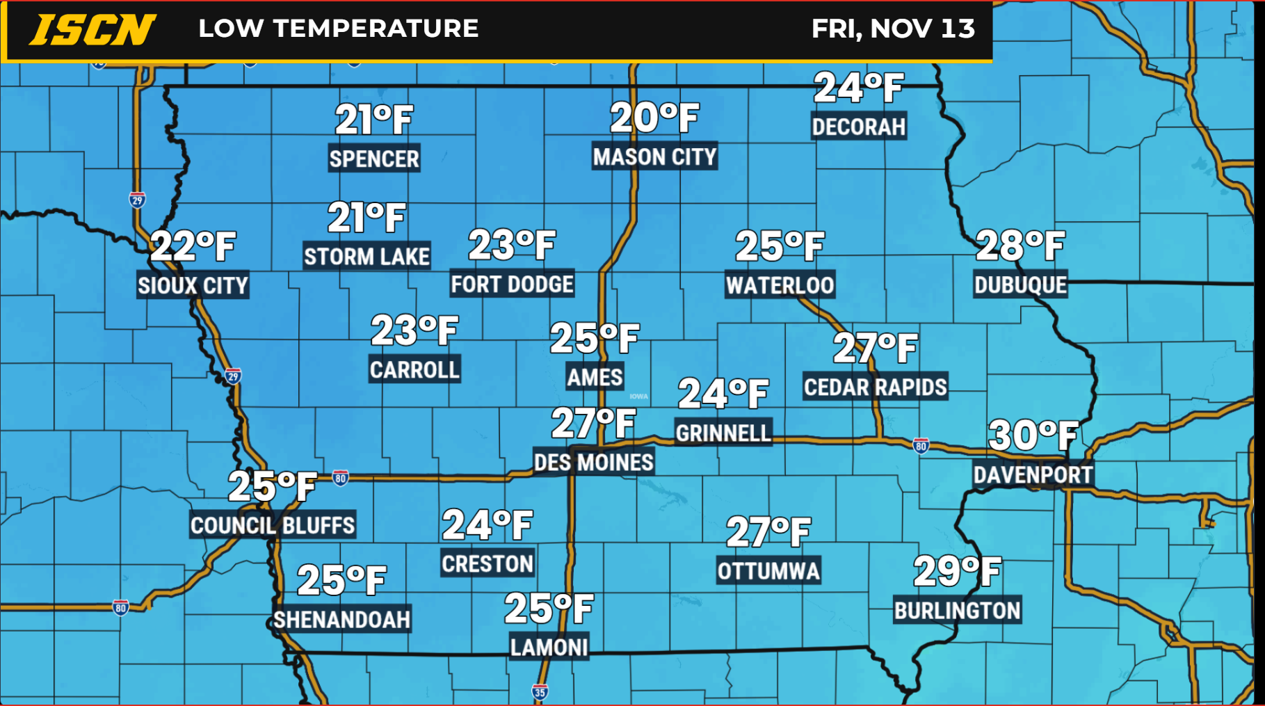
The coldest part of this week’s forecast will arrive Thursday night into Friday morning, when temperatures are expected to fall well below freezing across much of Iowa. Overnight lows will generally drop into the lower and middle 20s, with some locations potentially experiencing even colder readings depending on cloud cover and wind speeds. Northern Iowa will be particularly susceptible to the colder temperatures, although central and southern Iowa should also experience a widespread freeze. Friday morning’s temperatures could be among the coldest experienced so far this fall in some communities. Similar conditions are possible again Saturday morning, with another round of overnight lows in the 20s. Residents should plan for a couple of chilly mornings rather than a brief, one-night cold snap.
The combination of high pressure, relatively clear skies, and lighter winds will allow temperatures to fall efficiently overnight. When skies are clear, heat escapes from the ground more quickly after sunset, allowing temperatures near the surface to drop. This process is especially effective when winds become light and the atmosphere contains relatively little moisture. Any remaining sensitive outdoor plants should be protected or moved indoors before Thursday night, as temperatures in the 20s can cause significant damage. Outdoor pets and animals should also have adequate protection from the cold, and residents should be mindful of exposed water lines in vulnerable locations. While frost may develop in some areas, the more important concern is the potential for several hours of below-freezing temperatures.
Weekend Forecast: Mostly Dry Saturday, Small Rain Chance Sunday
The Iowa weekend weather forecast currently favors dry conditions across most of the state, with Saturday offering the best opportunity for outdoor activities. A broad area of high pressure will keep the atmosphere relatively stable, allowing clouds to decrease and winds to remain lighter than earlier in the week. Afternoon temperatures should generally reach the upper 30s and 40s across northern Iowa, with 40s more common farther south. Although temperatures will remain chilly, the combination of lighter winds and dry weather should make Saturday more comfortable than Wednesday or Thursday. Overnight temperatures will still be cold, particularly early Saturday morning when many communities will begin the day in the 20s. Anyone attending outdoor events should dress in layers and prepare for temperatures to fall quickly after sunset.
Sunday’s forecast carries more uncertainty as another low-pressure system moves across the southern and central Plains. Most forecast guidance currently keeps the main area of precipitation south of Iowa, but a more northerly storm track could bring light rain into the southwestern part of the state. Rain chances are currently around 15% to 30% near southwest Iowa and adjacent portions of southeast Nebraska, with the greatest potential occurring Sunday morning into the afternoon. Even if precipitation reaches Iowa, rainfall amounts are expected to remain light because moisture availability will be limited. Most of the state, including central, northern, and eastern Iowa, is expected to remain dry. Confidence is relatively high in a mostly dry statewide weekend, but lower regarding whether any measurable rain will reach southwest Iowa on Sunday.
There is also a small amount of uncertainty surrounding precipitation type near the western edge of this system. Some longer-range model simulations introduce colder air that could briefly support a rain-and-snow mix, mainly around portions of southeast Nebraska and the surrounding region. However, most guidance currently favors rain, and there is not enough evidence to forecast accumulating snow across Iowa. Temperatures near the time of any precipitation are expected to be above freezing in the areas most likely to receive it. The more important forecast question is whether the storm system tracks far enough north to bring precipitation into Iowa at all. Additional forecast updates should help clarify the storm track and any precipitation concerns as Sunday approaches.
Warmer Temperatures Return Early Next Week
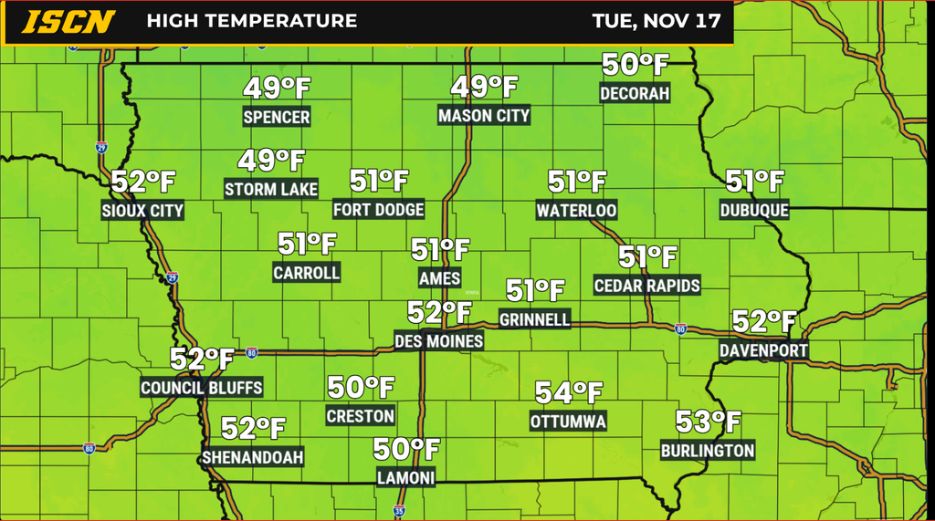
The colder weather pattern is not expected to last indefinitely, with a gradual warming trend becoming more likely during the first half of next week. As the Canadian high-pressure system shifts eastward, the flow of cold air into Iowa should weaken and allow temperatures to recover. Afternoon highs could return to the lower and middle 50s across many communities Monday and Tuesday, with some locations potentially reaching the upper 50s. This would represent a noticeable improvement from the colder conditions expected Thursday through Saturday. The warming trend may develop more slowly across northeastern Iowa, where lingering colder air could keep temperatures below 50 degrees a little longer.
Most of Iowa should remain dry through the beginning of next week as high pressure continues to influence the region. However, the larger weather pattern may become more active toward the middle of next week as another disturbance approaches from the western United States. Forecast models currently disagree on how quickly that system will move eastward and whether enough moisture will return to support meaningful precipitation. Some solutions suggest another opportunity for rain, while others keep the more active weather farther away from Iowa. There is not enough agreement to confidently identify a specific arrival time or expected rainfall amounts. For now, the most likely outcome is a gradual warmup early next week, followed by the possibility of additional weather changes later in the week.
Iowa’s weather can change quickly, especially during the transition from fall into winter. Stay connected with IowaWeather.com for the latest Iowa weather forecast, live weather radar, current conditions, and updates on approaching weather systems. You can also download the ISCN Weather App to follow changing weather conditions across the state.