Severe Storm Threat Increases Tonight
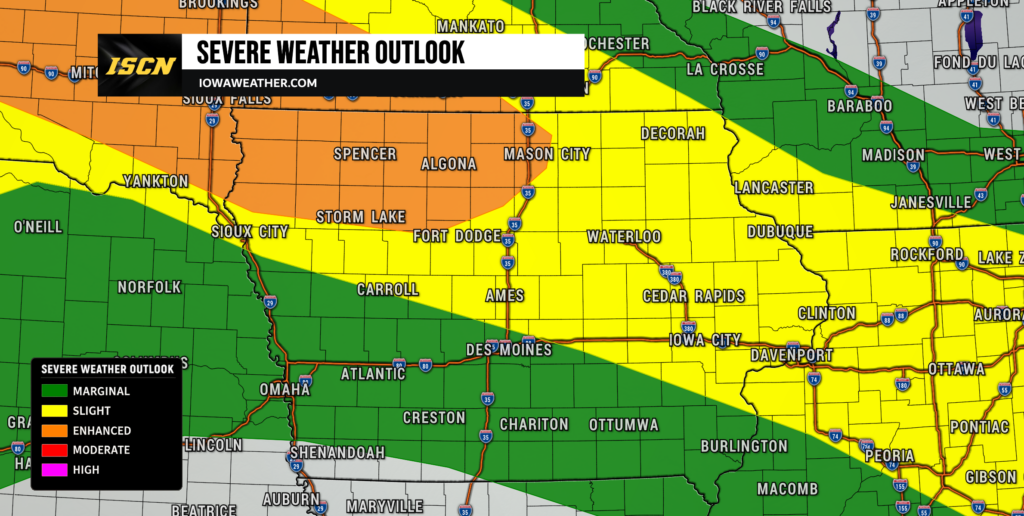
The most important severe weather period begins Monday evening northwest of Iowa before storms move toward the state overnight. Thunderstorms are expected to develop across portions of South Dakota and potentially organize into a larger mesoscale convective system, or MCS, which is essentially a large and organized cluster of thunderstorms. That system should move east or southeast toward Minnesota and Iowa, with northwestern Iowa currently having the greatest chance of being affected. The primary severe weather concern will be damaging straight-line wind gusts, especially if individual storms merge into a well-organized line. Large hail is also possible, particularly while storms remain more isolated or clustered earlier in their evolution. Some storms farther northwest could initially produce hail approaching two inches in diameter before wind becomes the more dominant hazard as the system grows.
Confidence is fairly high that thunderstorms will develop somewhere across the northern Plains tonight, but confidence is lower regarding their exact path, timing and strength once they reach Iowa. One important factor will be the low-level jet, a stream of stronger winds several thousand feet above the surface that can provide thunderstorms with additional moisture and energy overnight. Some forecast guidance shows that jet becoming strong enough to help maintain an organized severe storm complex well into Iowa, while other guidance shows a weaker setup that would allow storms to gradually lose intensity. The most likely corridor for the stronger storms currently favors northern Iowa, especially areas north of Interstate 80, with northwestern Iowa experiencing the greatest severe weather potential. Storms could begin entering western or northwestern Iowa late Monday night and continue spreading east through Tuesday morning. Residents across northern Iowa should have a reliable way to receive warnings overnight because the strongest storms may arrive while many people are sleeping.
Heat and Humidity Build Through Wednesday
Hot and very humid conditions will continue across Iowa through at least Wednesday, with the greatest heat focused on central and southern portions of the state. Monday afternoon temperatures should generally reach the 80s to around 90 degrees, while the combination of heat and high humidity produces heat index values in the 90s. Southern Iowa could approach a heat index of 100 degrees Monday, while portions of southwest Iowa may briefly reach the 100 to 105 degree range. Tuesday could become even more uncomfortable, with heat index readings around 100 degrees common across central and southern Iowa and potentially reaching 105 to 110 degrees close to the Missouri border. Wednesday remains warm and humid before cooler air begins making greater progress into the state later in the week. Cloud cover, thunderstorm debris and wildfire smoke could all affect the exact temperature today and Tuesday, meaning even a difference of a few hours of sunshine could noticeably change afternoon heat levels.
This is one of those situations where the temperature alone does not tell the entire story. Dew points well into the 70s across portions of Iowa will make the air feel considerably hotter than the actual temperature, especially during the afternoon and early evening. Residents working outdoors should plan for frequent breaks, plenty of water and access to shade or air conditioning when possible. Warm nighttime temperatures will also limit how much relief some communities receive after sunset. The location of thunderstorms and their leftover cloud cover will determine which areas become hottest from day to day, so the temperature forecast may need adjustment as each storm complex develops. For anyone searching for the weather tomorrow, Tuesday currently appears to remain very warm and humid across much of Iowa despite morning storm chances.
Wildfire Smoke Keeps Iowa Skies Hazy
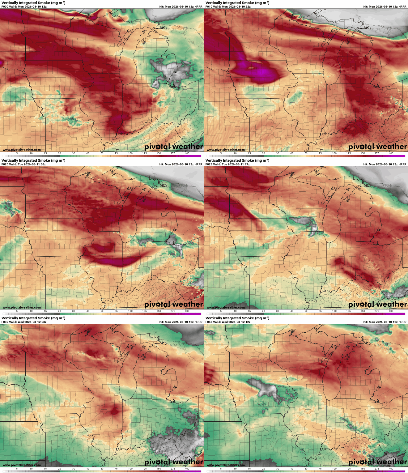
Wildfire smoke will continue passing over Iowa through Wednesday and may give the sky a hazy or milky appearance even when clouds are limited. The smoke is primarily located above the surface, where it can filter incoming sunlight before it reaches the ground. That filtering could knock a few degrees off afternoon temperatures in some areas and may also slightly reduce the amount of instability available for thunderstorms during the day. Smoke aloft is one reason there remains some uncertainty regarding exactly how hot Iowa becomes Monday through Wednesday. The haze may also produce a more orange or reddish appearance to the sun around sunrise and sunset. Based on the current forecast information, the primary impact is expected to be reduced sunshine rather than a widespread surface air-quality problem.
That distinction is important because visible smoke does not necessarily mean the air people are breathing near the ground contains the same concentration of particles. Surface air quality can change quickly if smoke mixes downward, so conditions should still be monitored if the atmospheric setup changes. For now, the thicker smoke layer is expected to remain elevated as west-to-northwest winds continue carrying smoke over the region. A change in the upper-level wind pattern later this week should eventually shift the source of air moving into Iowa and reduce the persistent smoke. Until then, hazy skies may remain noticeable even between rounds of clouds and thunderstorms. The smoke also adds another variable to the temperature forecast because thicker concentrations can noticeably reduce solar heating.
More Thunderstorms Possible Tuesday and Wednesday
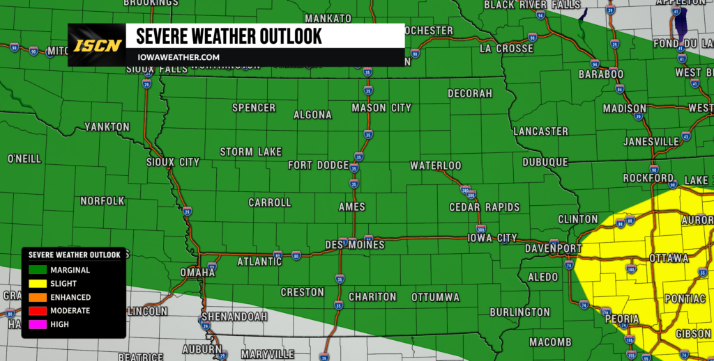
Tonight’s storms will not end the active weather pattern, with additional opportunities for thunderstorms continuing Tuesday night, Wednesday and Wednesday night. Tuesday morning’s storm complex should gradually move away from Iowa, although precipitation could linger into part of the afternoon depending on how quickly the system progresses. Another round could then develop to the west or northwest Tuesday evening and move toward the state overnight, following a pattern similar to Monday night. The exact location of the next storm corridor will depend heavily on boundaries left behind by the previous round, making day-to-day details difficult to pin down this far in advance. Severe wind gusts and hail remain possible with stronger thunderstorms Tuesday, although the severe threat appears more localized than tonight’s potential. By Wednesday, isolated damaging wind gusts remain possible as another very moist and unstable air mass sits across the Missouri and Mississippi valleys.
Repeated thunderstorm chances do not mean every Iowa community will receive rain every day. These systems will likely occur in corridors, meaning one part of the state could experience multiple thunderstorms while another location only a short distance away receives little rainfall. Overnight periods currently appear to have some of the better opportunities because stronger winds just above the surface repeatedly develop after sunset and help fuel thunderstorms. This pattern is particularly difficult for precise local forecasting because each previous storm complex can move boundaries and alter the atmosphere for the next one. Confidence is therefore higher in the overall active pattern than in exact hourly thunderstorm timing beyond Tuesday morning. Residents planning outdoor activities should continue checking the local weather forecast as these smaller-scale details become clearer.
Heavy Rain and Flooding Risk Grows Late This Week
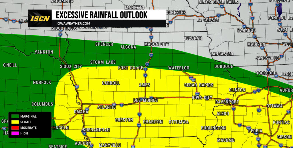
The threat for heavier rainfall becomes more significant Wednesday night into Thursday as a deeper supply of tropical moisture spreads into the Midwest. Atmospheric moisture levels are forecast to climb well above typical mid-August values, giving thunderstorms the ability to produce very high rainfall rates. A corridor from eastern Nebraska into western Iowa currently has roughly a 60 to 70 percent chance of receiving at least one inch of rain during the Wednesday and Thursday period, with the strongest signal extending from near Omaha toward Atlantic. The heavy-rain corridor could eventually extend much farther across Iowa as storms follow the nearly stationary boundary from the Missouri Valley toward the Ohio Valley. Thursday currently carries a more organized excessive-rainfall concern, while much of Iowa remains in at least a continued heavy-rain risk Friday. Exact totals are still too uncertain to forecast confidently because small changes in the position of the front could shift the heaviest rainfall corridor by many miles.
Flooding becomes more of a concern if thunderstorms repeatedly travel across the same communities, a process meteorologists call training. Instead of one storm moving through and ending the rain, multiple storms can follow nearly identical paths and produce several rounds of heavy rainfall. That possibility increases Thursday as deep moisture becomes established along a slow-moving or nearly stationary boundary. Urban locations could respond particularly quickly if rainfall rates become intense, with ponding on streets and localized flash flooding possible. Agricultural areas could also experience significant runoff if several inches of rain occur over a short period. Confidence in a period of heavy rain somewhere across Iowa is increasing, but confidence regarding exactly which counties receive the highest totals remains lower and should improve during the next several forecast cycles.
Cooler Air Arrives Late in the Week
A break from the heat should begin arriving from north to south later Thursday and Friday as cooler Canadian air pushes into the region. Northern Iowa will likely experience the change first, while the boundary could take longer to clear southern portions of the state. Afternoon temperatures behind the front may fall into the 70s, providing a noticeable difference from the heat index readings near or above 100 degrees earlier in the week. Northeast Iowa should also trend cooler and less humid during the latter half of the week as high pressure builds southward. How far south the cooler air progresses will influence both temperatures and where the greatest thunderstorm chances set up Thursday and Friday. Areas near and south of the boundary could remain vulnerable to repeated rainfall even as northern Iowa begins experiencing more comfortable conditions.
The temperature forecast later this week carries somewhat greater confidence than the exact precipitation forecast because models consistently show cooler air moving south from Canada. There is still disagreement over precisely where the boundary will stall, and that difference could become important for both rainfall totals and daytime temperatures. If the front pushes farther south, more of Iowa would experience cooler and drier conditions sooner. If it stalls across the state, southern Iowa could remain warmer and several additional rounds of thunderstorms would remain possible. Either way, the prolonged stretch of heat should begin easing by the end of the workweek. Highs in the 70s appear increasingly possible across portions of Iowa as the cooler air becomes established.
Looking Ahead
There are still several forecast details that will change as individual storm systems develop, particularly the timing and track of tonight’s MCS and the eventual heavy-rain corridor later this week. The overall pattern, however, supports multiple opportunities for thunderstorms rather than a prolonged dry stretch. Iowa residents should pay particular attention to overnight forecasts because several of the stronger storm opportunities may occur after dark. Keep checking IowaWeather.com for updated forecasts, weather radar, severe weather information and changes to the expected storm timing throughout the week.