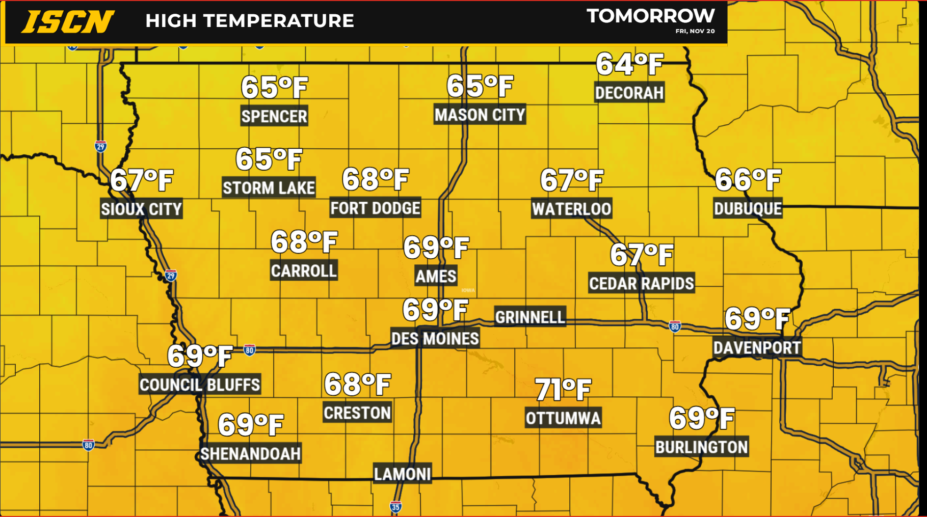
Iowa’s stretch of unusually warm November weather will continue through Saturday, but some significant changes are on the horizon. Temperatures will remain well above normal through the end of the workweek, with highs climbing into the 60s across much of the state and a few locations potentially approaching 70 degrees Friday. Strong southerly winds will also return Friday, with gusts approaching 50 mph in western and northwestern Iowa. A developing storm system will then bring widespread rain and a few thunderstorms this weekend before much colder air settles across the state Sunday and continues into Thanksgiving week.
Strong Winds Return Friday as Temperatures Approach 70 Degrees
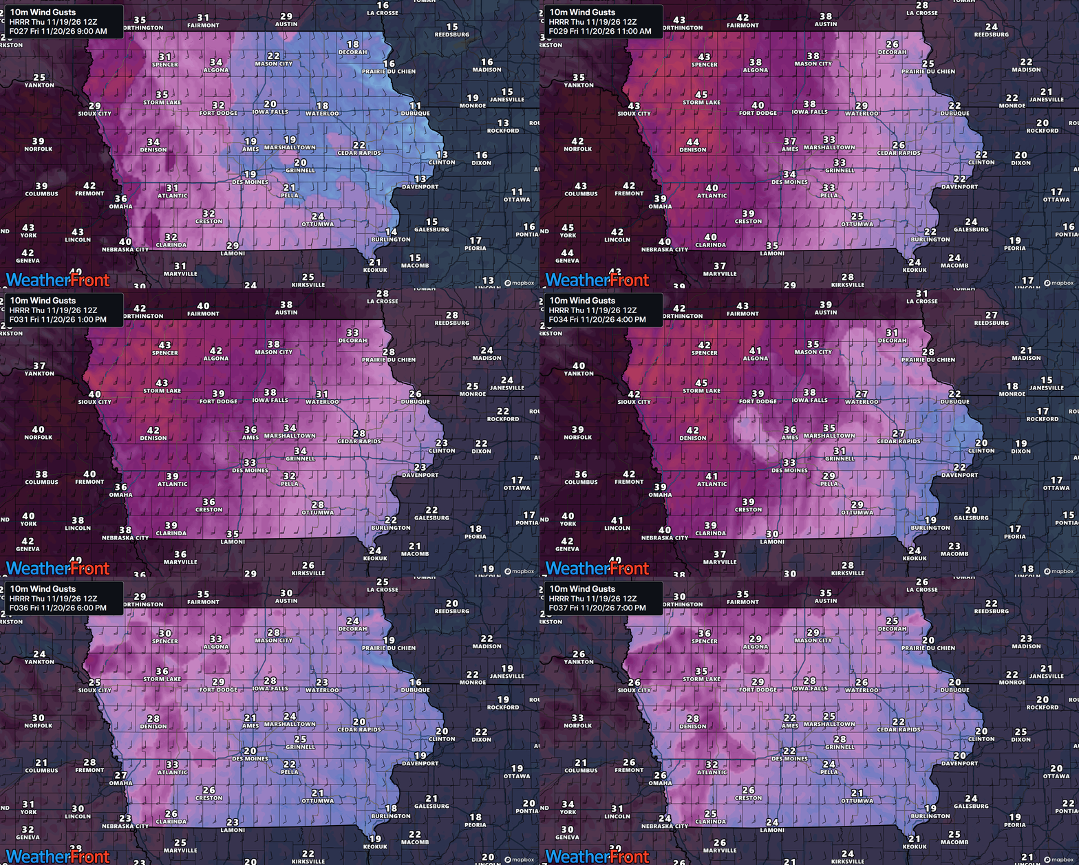
Friday will feature another round of unusually warm November temperatures, but the biggest weather story will be the return of strong southerly winds across the state. A strengthening area of low pressure moving out of the Rocky Mountains and into the Central Plains will create a tightening pressure gradient, allowing winds to increase substantially throughout the day.
The strongest winds are expected across western and northwestern Iowa, where sustained speeds could approach 30 mph and gusts may reach 45 to 50 mph. Wind Advisories may eventually be needed across portions of the region.
Central Iowa will also experience gusty conditions, with winds potentially reaching 35 to 45 mph in some locations, while eastern Iowa will generally see somewhat lighter winds. The exact strength of the winds will depend partly on cloud cover. If low clouds remain widespread, they could limit how efficiently stronger winds above the surface reach the ground. However, if sunshine allows the atmosphere to mix more deeply, stronger gusts could develop.
Despite the wind, temperatures will remain unusually mild for late November. Most of Iowa should reach the 60s, with some locations potentially approaching 70 degrees, particularly where clouds are limited. Increasing moisture will eventually lead to more widespread cloud cover Friday night as the approaching storm system begins influencing Iowa’s weather.
Widespread Rain and Isolated Thunderstorms Expected This Weekend
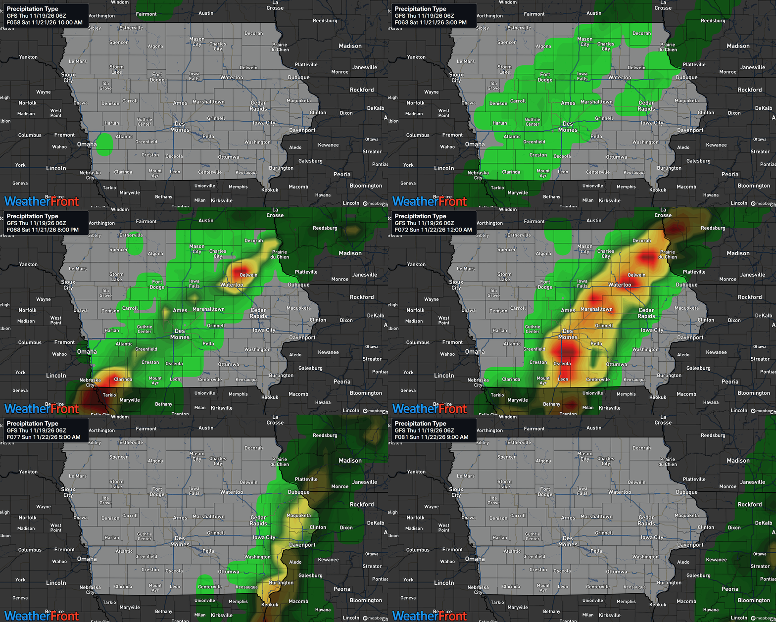
A strong cold front associated with the developing Plains storm system will move across Iowa this weekend, bringing widespread rain and the possibility of a few thunderstorms. Unlike some recent weather systems that have struggled to produce meaningful precipitation, this system will have access to a considerably deeper supply of atmospheric moisture moving northward from the Gulf.
Rain chances could begin increasing across northwestern Iowa late Friday night into Saturday morning as the cold front approaches. Showers should gradually become more widespread Saturday afternoon and evening, particularly across western and central Iowa, before expanding into eastern portions of the state Saturday night. Some rain could linger into early Sunday across eastern Iowa before the system moves away.
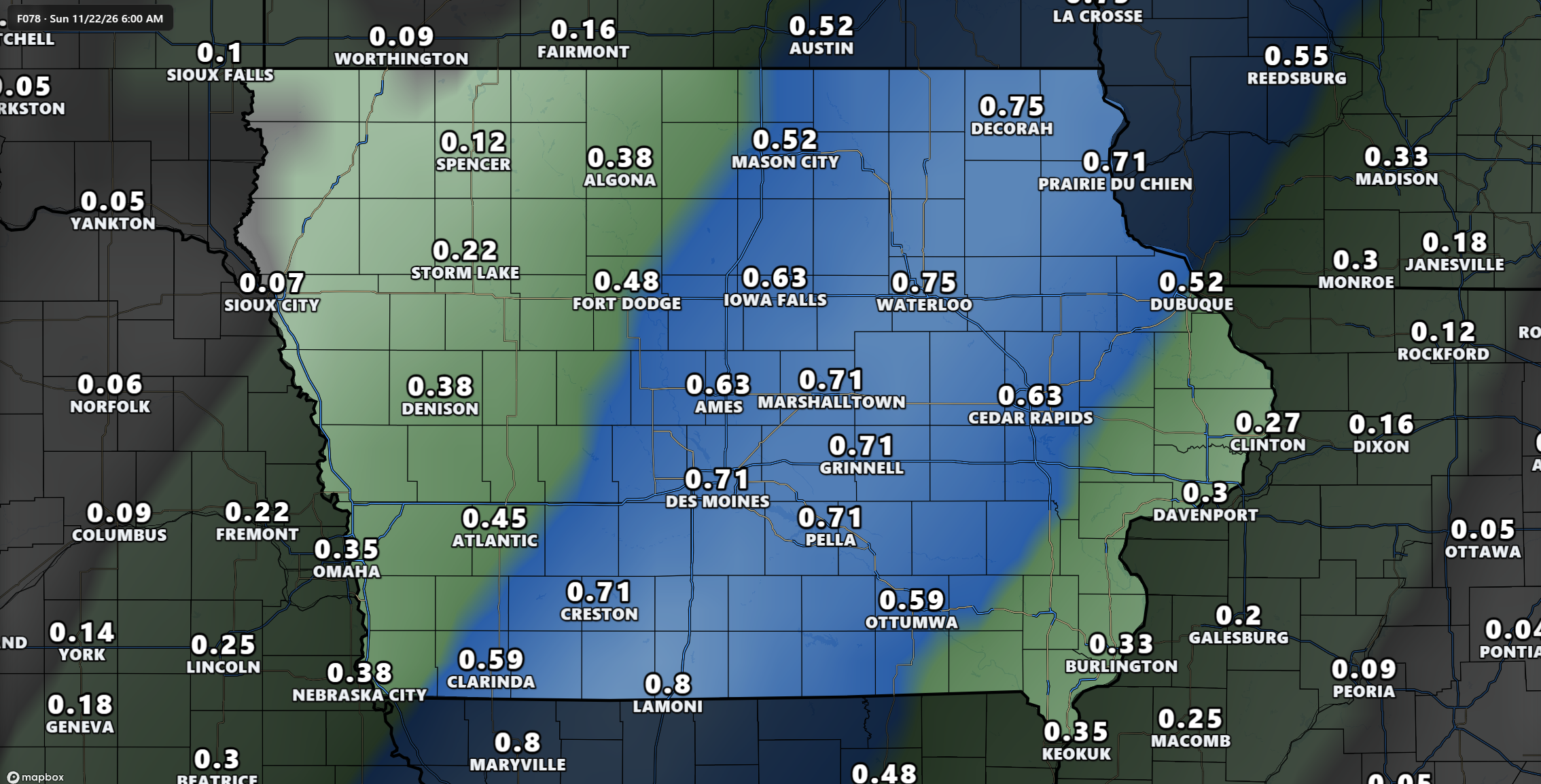
Forecast guidance continues to suggest that much of Iowa will receive measurable rainfall, with many locations potentially picking up around a quarter of an inch. However, some areas could receive a half-inch or more, particularly across central and eastern Iowa, where the combination of deeper moisture and stronger atmospheric forcing may support more organized rainfall.
Although a few thunderstorms may develop within the rain, severe weather is not currently expected. Atmospheric instability appears relatively limited, which should prevent storms from becoming particularly intense. Most locations will simply experience periods of rain, although an occasional rumble of thunder cannot be ruled out.
There is still some uncertainty regarding the exact placement of the heaviest rainfall, particularly as forecast models continue adjusting the position and movement of the frontal boundary. However, confidence is increasing that Saturday afternoon through Saturday night will bring the most widespread precipitation across Iowa.
Much Colder Temperatures Arrive Sunday
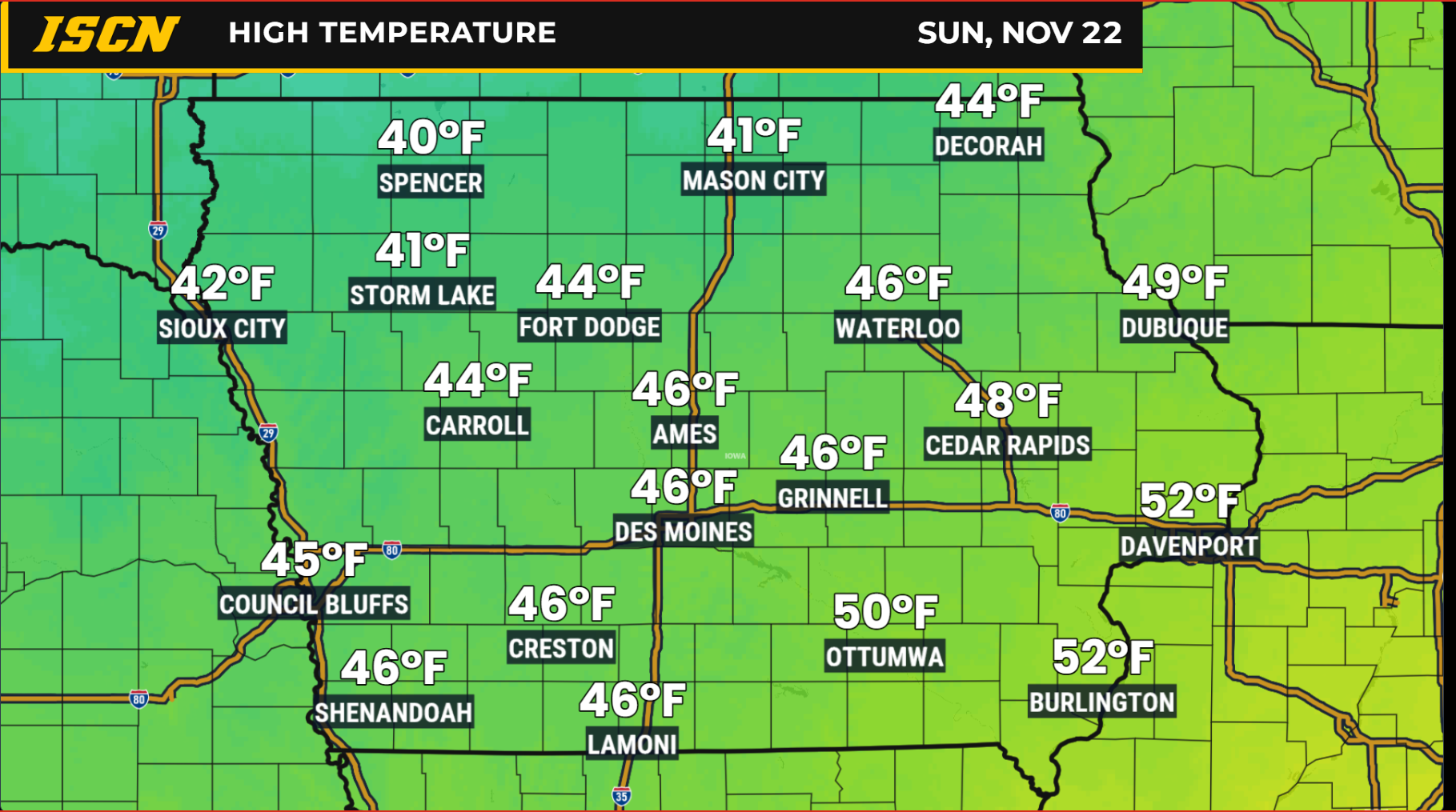
The passage of the cold front will bring a significant change in Iowa’s temperatures, ending the unusually warm conditions that have dominated much of the week. After several days with afternoon highs in the 60s, temperatures Sunday will struggle to climb out of the upper 30s and 40s across much of the state.
The cooldown may become noticeable as early as Saturday afternoon across western and northwestern Iowa, where temperatures could begin falling behind the advancing cold front. Farther east, milder conditions may hold on longer before colder air arrives Saturday night into Sunday.
By Sunday morning, the colder air mass will be firmly established across much of Iowa, with brisk conditions making it feel even colder outdoors. Afternoon temperatures will generally remain in the upper 30s and 40s, bringing the state much closer to typical late-November conditions.
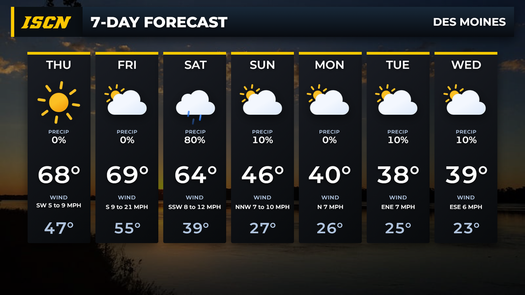
The colder pattern will continue into the beginning of next week as Canadian high pressure settles across the central United States. High temperatures Monday and Tuesday will generally remain in the upper 30s and 40s, while overnight lows fall into the 20s. Some northern locations could eventually experience temperatures dipping into the upper teens.
While this cooldown will feel substantial compared to the recent warmth, it is not particularly unusual for this time of year. November is a transition month in Iowa, and significant temperature swings frequently occur as stronger storm systems move across the central United States.
Thanksgiving Week Outlook: Cooler Weather, but Major Winter Storm Appears Unlikely
With Thanksgiving approaching, attention is beginning to turn toward the possibility of additional weather systems affecting Iowa and the surrounding region during one of the busiest travel periods of the year.
Current forecast guidance suggests that cooler temperatures will remain in place through much of Thanksgiving week, with daytime highs generally in the upper 30s and 40s and overnight temperatures frequently dropping below freezing.
Another disturbance could move through the central United States around Tuesday or Wednesday, potentially bringing additional precipitation to portions of the region. However, considerable uncertainty remains regarding the strength, track, and available moisture associated with this system.
For those planning to travel during Thanksgiving week, the current outlook is relatively encouraging, particularly compared to scenarios involving a significant winter storm. However, travelers should continue monitoring forecast updates as the holiday approaches, since even minor weather systems can create localized travel concerns when temperatures are near or below freezing.
Continue checking IowaWeather.com for the latest forecasts and updates as these weather systems approach. You can also follow the Iowa Storm Chasing Network and download the ISCN Weather app for radar, watches, warnings, and weather information across Iowa.