Severe Storms Sweep Across Eastern Iowa Wednesday Morning
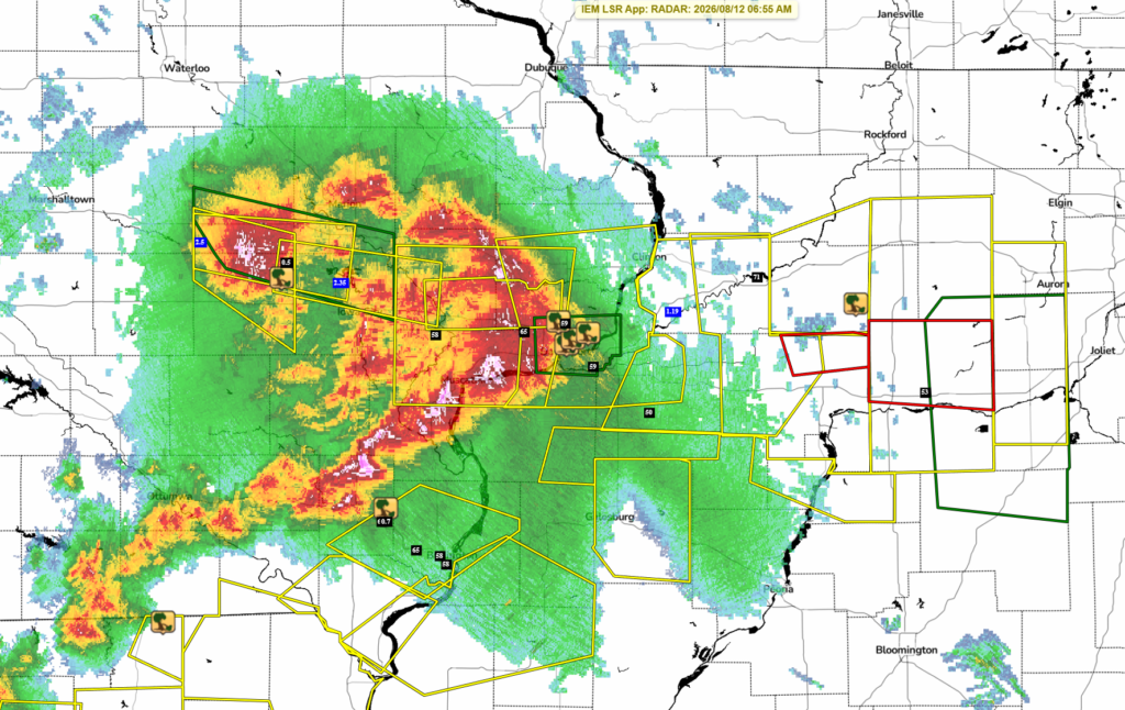
A line of strong to severe thunderstorms swept across eastern Iowa early Wednesday morning, August 12, bringing damaging wind gusts, downed trees, heavy rain and some hail before pushing into Illinois.
Severe Thunderstorm Warnings stretched across a large portion of eastern Iowa during the morning commute, beginning as far west as the Belle Plaine area and continuing east through the Iowa City region and Quad Cities before the storms crossed the Mississippi River into Illinois.
Numerous reports of wind damage accompanied the line, including snapped and uprooted trees. Measured wind gusts of 58 to 65 mph were also reported at several locations from the Interstate 80 corridor south toward Burlington.
Storms Intensify Across Eastern Iowa
The line of thunderstorms moved quickly eastward across the state Wednesday morning, producing pockets of damaging winds as it crossed eastern Iowa.
One of the earlier measured gusts came near Atalissa, where the Iowa Mesonet recorded a 58 mph wind gust at 6:13 a.m.
More substantial tree damage was reported near Homestead in Iowa County at 6:58 a.m. A trained spotter reported 12-inch-diameter limbs down, along with a 2-foot-diameter tree that snapped at its base and was moved approximately 30 feet.
Farther south, the storms eventually produced numerous reports of tree damage and strong winds around New London, Middletown and Burlington.
65 MPH Winds Hit the Quad Cities Area
The storms remained severe as they approached the Quad Cities.
An NWS employee measured a 65 mph wind gust one mile south-southeast of Walcott at 6:47 a.m. The ASOS at Davenport Municipal Airport later measured a 59 mph gust at 7:04 a.m.
At 7:09 a.m., a trained spotter approximately two miles north of Davenport reported 1- to 2-inch branches down, along with very heavy rain and strong winds.
Additional damage was reported around Riverdale, where a trained spotter reported trees approximately 2 to 3 feet in diameter snapped around 7:34 a.m.
Across the Mississippi River, a trained spotter two miles north-northeast of Rock Island, Illinois, reported 6-inch branches down and water covering roads at 7:12 a.m.
Photogenic Shelf Cloud Rolls Through the Quad Cities
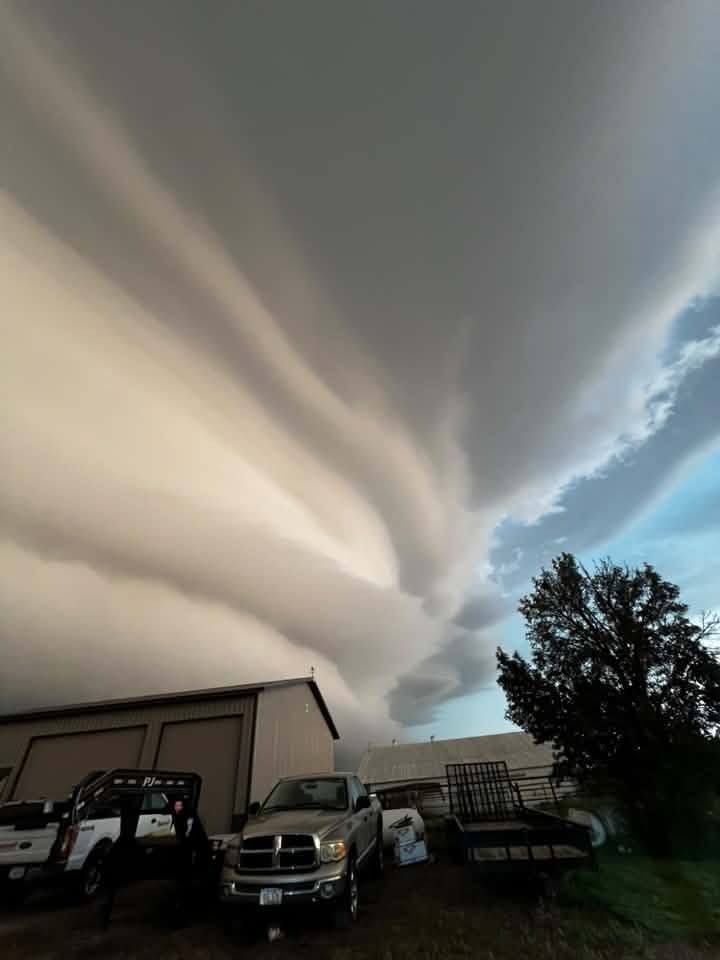
One of the most impressive sights from Wednesday morning’s storms wasn’t the damage—it was the storm itself.
As the line approached and moved through the Quad Cities, a dramatic shelf cloud developed along the leading edge of the thunderstorms. Numerous people across the area captured photos and videos as the low, ominous cloud swept across the Mississippi River corridor.
Shelf clouds typically form along the leading edge of a thunderstorm’s outflow, where cooler air rushing outward from the storm lifts warm, humid air ahead of it. Their appearance can be dramatic, and the strongest winds associated with a thunderstorm can arrive as or shortly after the shelf cloud passes overhead.
Click Here to Watch video of the shelf cloud moving through the Quad Cities:
Tree Damage Reported Around New London
Some of the more concentrated damage reports Wednesday morning came from the New London area in Henry County.
A personal weather station one mile west of New London measured a 61 mph wind gust at 7:23 a.m., according to a trained spotter. Just minutes later, at 7:29 a.m., a trained spotter in New London reported 0.70-inch hail.
An emergency manager reported numerous trees down in New London, including some that were uprooted, at approximately 7:30 a.m. The line continued east toward Middletown, where a trained spotter reported a 65 mph wind gust along Highway 34 near the Middletown exit at 7:39 a.m.
58 MPH Winds Recorded Around Burlington
Strong winds continued as the thunderstorms moved into the Burlington area. The Iowa Mesonet station in West Burlington recorded a 58 mph wind gust at 7:43 a.m.
Farther east, the ASOS at Burlington Regional Airport also measured a 58 mph wind gust at 8:09 a.m. as the line continued toward the Mississippi River and eventually into western Illinois.
The repeated measurements in the 58 to 65 mph range, combined with reports of snapped and uprooted trees, show that the line was capable of producing pockets of damaging winds across a sizable portion of eastern Iowa Wednesday morning.
Preliminary Severe Weather Reports
Here are some of the preliminary storm reports received from Wednesday morning’s storms:
| Time | Location | Report |
|---|---|---|
| 6:13 a.m. | 1 mile NW of Atalissa | 58 mph wind gust measured by Mesonet |
| 6:47 a.m. | 1 mile SSE of Walcott | 65 mph wind gust reported by NWS employee |
| 6:58 a.m. | 3 miles SSE of Homestead | 12-inch limbs down; 2-foot-diameter tree snapped at base and moved approximately 30 feet |
| 7:04 a.m. | Davenport Municipal Airport | 59 mph wind gust measured by ASOS |
| 7:09 a.m. | 2 miles N of Davenport | 1–2 inch branches down with very heavy rain and strong winds |
| 7:12 a.m. | 2 miles NNE of Rock Island, IL | 6-inch branches down and water over roads |
| 7:23 a.m. | 1 mile W of New London | 61 mph wind gust measured by personal weather station |
| 7:29 a.m. | New London | 0.70-inch hail |
| 7:30 a.m. | New London | Numerous trees down, including some uprooted |
| 7:34 a.m. | 1 mile N of Riverdale | 2–3 foot diameter trees reported snapped |
| 7:39 a.m. | Middletown/Highway 34 | 65 mph wind gust |
| 7:43 a.m. | West Burlington | 58 mph wind gust measured by Mesonet |
| 8:09 a.m. | Burlington Regional Airport | 58 mph wind gust measured by ASOS |
Storm reports are preliminary and may be updated as additional information is received.
Storms Continue East Into Illinois
After producing severe weather across eastern Iowa, the line crossed the Mississippi River and continued eastward into Illinois Wednesday morning.
For eastern Iowa, the event brought a combination of damaging straight-line winds, tree damage, torrential rainfall and isolated hail. The striking shelf cloud that accompanied the storms through the Quad Cities also provided one of the more memorable views of the morning.
Additional storm reports may continue to come in as damage is assessed throughout the day.
IowaWeather.com will continue to track additional reports and any further severe weather potential across Iowa.
(Story Image Credit: Amy Jo – Muscatine, Iowa)