Unprecedented Spring Snowstorm of 2013

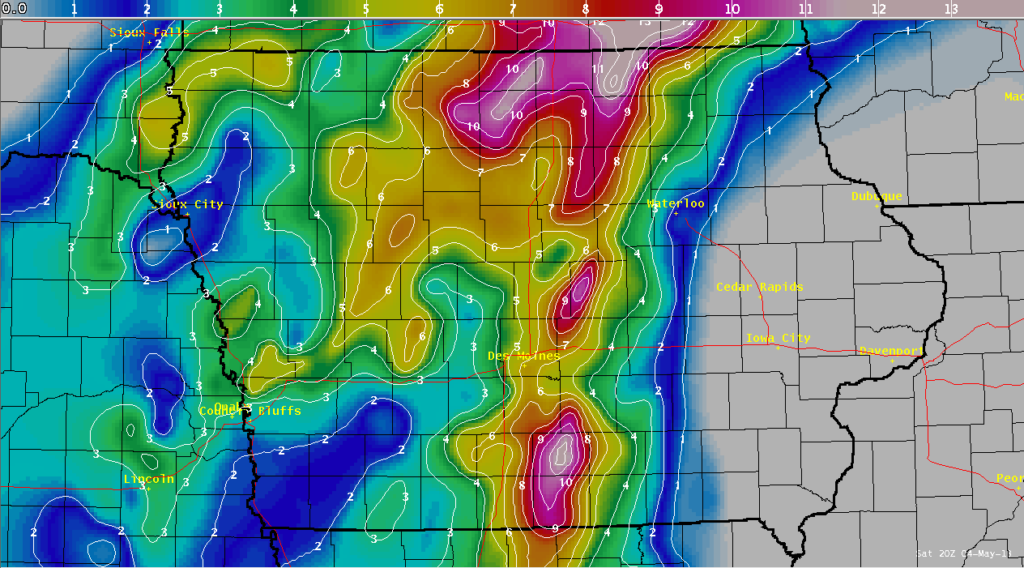
A spring snowstorm swept across the central United States from May 1 to 3, leaving record amounts of snow up and down the western Mississippi River Valley. Some southern locations in the United States saw their first ever May snowfall, while cities in Kansas and Missouri experienced their highest snowfall totals in over a century. The storm also set noteworthy May single day and storm total records for the states of Iowa, Minnesota, and Wisconsin. South central Iowa up through southeast Minnesota and western Wisconsin bore the brunt of the snowfall, with reports of more than 10 inches of snow not uncommon.
The storm hit after the last few days of April were characterized by warm, summer-like temperatures, making the abrupt end to the warm weather all the more jarring. A strong cold front passed through Iowa on April 30, causing temperatures to plummet. The surface observation map shows a stark change in temperatures across the state after the front’s passage.
A strong mid to upper level trough of low pressure from Canada slid southeastward behind the cold front, but a large stationary ridge of high pressure, known as an omega block, was taking shape across the eastern United States. The omega block’s forward progress inhibited the upper level trough, which stalled over Iowa, forming a cut-off low centered over the south central US by Friday morning, May 3.
The low meandered over the region for the next three days, drawing moisture from both the Gulf of Mexico and western Atlantic Ocean during its stay over the Midwest. The moisture worked up into Iowa, generating a wide swath of precipitation that fell for days straight. The synoptic setup for this event shows the synoptic lift that generated the precipitation shield over the region.
The precipitation shield first took the shape of rain showers over southeast South Dakota and northwest Iowa late on April 30th. This band of rain lifted northwestward during the overnight hours and transitioned to snow over far northwest Iowa just before sunrise on Wednesday, May 1. The snow then slowly marched southeastward over the next 36 hours. The leading edge of the precipitation shield consisted of light rain with embedded heavier showers. The rain eventually transitioned to a rain/snow mix and eventually snow as continued cold air advection and melting ice crystals cooled temperatures aloft below freezing.
The cold air advection and cooling due to melting snow caused the rain/snow line to shift all the way to east central Iowa. The line then became stationary late on May 2 as the upper level trough transitioned to a closed low. The rain/snow line then retreated back to the west during the day on May 3 as a broad region of warm air wrapped north and west around the eastern flank of the low. This surge of warm air eventually brought the snow to an end by late in the day on Friday, but a widespread, cold rainfall continued into the weekend with the cut-off low spinning overhead.
The snowstorm caused numerous accidents and spin outs across the affected regions, and sporadic power outages also occurred as snow-coated tree branches broke and took out power lines. The storm’s impact was significant and unexpected, reminding us that even in the spring, weather can be unpredictable and dangerous.